Friday night snow?

Tuesday, Jan.9,2018  3 P.M.

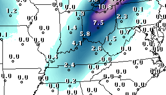
GFS points to snow Friday night!

Here’s the latest prediction from the GFS 2.5 km model:

Looks exciting, doesn’t it?  But don’t get too excited yet.  This prediction is definitely an outlier, at least so far.  The GFS ensemble shows(a group of GFS models run under slightly different starting conditions) shows a wide range of possible solutions for this future storm.  The Euro and Canadian models also are much lower with their forecasts.  But, it’ll fun to see how it develops this week.


Quick update

Sun., Jan 7, 2018

The short term models have, as expected, all gone to a forecast for the Louisville area which consists of almost all rain tonight and tomorrow morning AND  a few periods of sleet/snow mixed in.  But, essentially we’re just looking a a rain situation locally as temperatures remain above freezing all night.

Doesn’t look like the NWS has given up on its icy prediction yet.

What’s going to happen tonight?

Sunday, January 7, 2018

Which precipitation type will dominate tonight?

Forecasts have been calling for snow and/or sleet and/or freezing rain and/or rain for tonight and Monday morning for several days now.  But, as we get closer to the event, the actual sequence of events seems to be coming into clearer focus.  The computer models are still quite varied – I’ve just looked at five different models and the results still are different.  One says mostly snow, another says mostly freezing rain/sleet, two say about a fifty-fifty split between icy types and rain, while another one predicts mostly plain old liquid rain.

So that aspect of the models doesn’t provide much help.  So maybe it’s time to put a little common sense human forecasting to work.  One thing the models do agree on is surface temperatures.  In general, they all hold surface temperatures above freezing overnight and tomorrow.  Thus, any icy precipitation that mixes in should melt on roadways.  Concrete sidewalks and roadways could get a bit icy late this evening.  Once precipitation begins this evening, temperatures will drop  few degrees for an hour or two.  During that time we’ll see our best chance for icy precipitation mixing in with rain.  After midnight, by far the dominant feature will be rain as temperatures rise into the mid to upper 30’s by morning.

So, summary, when all is over, this system should cause only a few, if any, problems for the Louisville area any all roads should be fine (although wet) for rush hour.  However, north and northeast of Louisville more ice will mix in, especially those areas which still have some snow on the ground.  Numerous road problems are likely in these areas.

Potential storms update

Sat. Nov.18, 2017  3:10 P.M.

Severe Thunderstorm WATCH expanded  WHY?

The Storm Prediction Center has seen fit to expand the Tstorm Watch to cover most of Kentucky.  At least for northern half of KY and southern half of IN, watch seems pretty useless.  As mentioned earlier, the part of the storm line approaching our region has lost any severe weather characteristics.

So, risk of severe thunderstorms for Louisville area is extremely low.  Southern KY has a very slight risk.

Nasty weather late this afternoon

Saturday, Nov. 18, 2017  2 P.M.

Cold Front approaching rapidly

A strong cold front is pushing rapidly (about 50 mph) southeastward across the lower Ohio Valley. Currently, is is stretched from about Indy southwest to near Paducah.  That pushes the front through the Louisville area between about 4:00 and 5:00 this afternoon.  The front has become active with a narrow line the showers/thunderstorms along it.

The Storm Prediction Center has issued a Severe Thunderstorm Watch for all of southwestern Indiana WEST of I-65 and most of KY west of Louisville.  Louisville is not in the Watch.  Nevertheless, the front is already beyond it’s severe weather.  A couple of severe winds reports came from southern Illinois as the system developed (often the case in marginal situations), but over the past hour or so the energy has become more evenly distributed along the cold front.  Thus, the threat for severe weather in Louisville area is very low.  Strong winds, yes; severe winds, probably not.

What to expect:  Winds will be quite gusty as the front approaches.  Wind gusts of 35 to 45 mph will be likely.  The cold front will bring a narrow line of showers and thunderstorms through the local area between about 4:00 and 5:00 P.M.  During that time we may see gusts reach 50 mph.

Temperatures will remain in the mid 60’s before the rain.  An hour later they should be in the lower 50’s.  After the rain departs, strong winds will continue for a few more hours.  This time they will be from the northwest around 30-40 mph.

NOTE:  Yesterday I was hoping the cold front would arrive around 3:30 so that the UL-Syracuse game start would be delayed, but played straight through after that.  Now, it looks as though the game should start but still be in the first quarter when the thunder hits. Then a delay of 60 minutes to 90 minutes before resumption..

Very windy day Saturday

Friday, Nov. 17, 2017

Strong storm system will move through the area tomorrow.

A  storm system will form tonight over MO/AR and develop rapidly as it races across Illinois and Indiana into Ohio by late tomorrow.  Two active fronts will move across our area by tomorrow evening.

First, a warm front will push northward through the area tonight.  This should produce widespread showers over KY and so.IN after midnight.  A few scattered elevated thunderstorms will be possible along the front.  If you hear thunder in your neighborhood, there’s a good chance you’ll get some small hail mixed in with the rain.  Rain connected with the warm front should be out of the Louisville area by 8 A.M.

Then we’ll have a period of 4-7 hours of mostly dry weather as the winds increase dramatically.  By late morning into the evening, winds will become quite strong thanks to that strong storm passing to our north.  Southerly winds should gust into the 30-40 mph range during that time.

Second, the cold front associated with the storm system.  That should arrive between 2 P.M. and 5 P.M.  It will sweep rapidly through the area from northwest to southeast.  Ahead of the front will be a narrow line of gusty showers and possible thunderstorms.  Winds could briefly gust to 40-50 mph during this time.  Rain should last only a short while, probably less than one hour.  During this time, temperatures will tumble quickly from the sixties before the rain down to near 50 as the rain ends.

Then back to colder weather by Sunday.

I realize the scenario looks bad for UL’s game with Syracuse.  Lamar Jackson’s possible (probable?) last game in Louisville will be played with a wet field (which has very good drainage, by the way) but it looks to me as though most (maybe all) of the game will be played in dry weather.  It all depends on the cold front’s ability to create thunderstorms.  When the front arrives, if thunder is in the area the game will be delayed.  When the thunder leaves the area, the game will start or resume with dry weather the rest of way.  But, they’ll still have to contend with those strong winds.


Update on tonight’s weather

Sunday, Nov. 5, 2017  8 P.M.


Good news from earlier update.

1).  Storms have weakened faster than expected.  Still an outside chance for some near severe storms over south central IN – more than 30 miles north of Louisville.

2).  Winds locally will probably average a little below the values mentioned earlier, but 40-45 mph wind gusts will still be likely for many of us.

3).  System is a little faster than mentioned earlier.  Now looks like the line/area of storms will pass through the metro area between 9:30 P.M. and 12:30 A.M.

Strong Storms likely early tonight.

Sunday, November 5, 2017  5 P.M.

A cold front will sweep across the area tonight bringing an end to the recent warm weather.  The warm air has brought an unusually large amount (for November) of moisture into the lower Ohio Valley, so the colder air looks as thought it’ll arrive along with rain, thunder and strong winds. just how strong the winds will be is the primary concern now.

This system has plenty of wind fields, convergence patterns and overall dynamics which provide an important side of the severe weather equation.  However, the thermodynamic part of the equation, while sufficient for severe storms now (from southern Missouri to central Indiana), is forecast to weaken quickly over the next few hours.

A similar system last spring stayed active all night creating probably our worst severe weather outbreak of this year. Chances for a repeat don’t look too high to me – storms along the front are not nearly as strong or widespread as the previous case.

Here’s what I expect to happen: A line of strong-to-severe thunderstorms to our west will move rapidly (30-40 mph) east this evening and be located from about western Ky to Evansville to Indy by 9 P.M.  This line of thunderstorms will cross the Louisville area from about 10 P.M. until 1 A.M.  After that, the frontal storms will race eastward across the rest of KY.

In terms of what is called “sensible” weather, the Louisville area can expect…

8 – 10 P.M. – Strong, gusty southerly winds will precede  the line of thunderstorms.  Winds should gust from 25-35 mph with some gusts reaching to around 40 mph.

10 P.M. – 1 A.M.  Line of strong storms sweeps rapidly through the area.  Winds should gust to 40-50 mph with a few higher gusts.  Gusts over 50 mph should occur mostly north of Louisville.  Brief periods of heavy rain are likely and some of the strongest storms may produce small hail.  Power outages and some tree/limb damage are likely.  However, such areas should be localized and not widespread.

AFTER 1 A.M. – Rain fades quickly but wind gusts remain in the 25 – 35 mph range for a couple of hours before fading  by morning.   One note of caution:  The area  roadways will probably be covered in leaves by morning.  Wet leaves on the roads can be almost as slippery as ice.  Be advised.

Weekend rain clarification

5 P.M. Saturday, Oct 7, 2017

Turns out we don’t need Hurricane Nate to get some much-needed rainfall.  A weak cold front entering the lower Ohio Valley has been squeezing out some brief light showers around the Louisville area this afternoon.  So far, the rain has not been enough to ease any soil dryness.  However, from 7 P.M. until Midnight they should become more numerous.  Some spots could get as much as half an inch this evening.

Rains from Nate should reach us tomorrow morning and continue through the afternoon.  Models have shifted Nate’s path slightly west again so my earlier prediction for Nate’s rains will have to pushed up somewhat.

My latest estimates for the Louisville area:

This evening:  about .25″ to .40″  of rain (higher amounts west and north of Louisville)

Sunday:  about .35″ to .80″

NOTE:  Sunday’s rainfall totals will rapidly increase as you head southeast from Louisville.  Southeastern KY may see as much as 6″+ of rain.

Can Nate help us?

Friday, Oct. 6, 2017  11 A.M.

Recent changes cast doubt on current forecast.

This morning’s GFS model run has pushed Nate’s path farther east than the current forecast implies.  If this works out, and it likely will, our local hopes for some very beneficial rain this weekend are dimming.  Current official forecast calls for widespread 1″-2″ rainfall over our area late tomorrow into Sunday.  Forecast  changes this morning would indicate our rainfall will probably be less than half that of the current forecast.

As it looks now, we should get at least some rain this weekend, but not enough to take much of a bite out of our growing drought conditions.  A quarter to half an inch would be nice, but I’m getting the feeling I may be too optimistic.

Bummer.