Monthly Archives: January 2016

January thaw has late arrival.

Thursday 1/28/2016

Weather update:

After a couple weeks of wintry weather, a common January weather feature is entering the game – the January Thaw.  For centuries, weather watchers have noticed a tendency for a period of milder, calmer weather to hit the eastern half of the U.S. during the latter part of January.  This year (it doesn’t happen happen every year) it’s a bit late. We’ve been experiencing a rather weak example of it this week, but it’ll really kick into action by the weekend.  Temperatures could reach 60 or so then, but it’ll be even warmer early next week when even 70 degrees is not out of question. A strong storm will come out of the southwest early next week and move northward through the Mississippi Valley.  That will bring us strong southern winds and warm, rainy weather Tuesday and Tuesday night.  That’ll be it for this year’s “Thaw” as wintry conditions will return by midweek.

The “10 year deadline” has passed.  Why are we still here?

It was 10 years ago this week when former Vice President Al Gore made his (at the time) famous proclamation that if we didn’t make drastic efforts to end global warming in the next 10 years, Earth was doomed.  Well, the years have passed, Earth hasn’t warmed (according to satellite data), we haven’t done much to reduce the supposed enemy – carbon dioxide, and everything seems to be rolling along smoothly.  Of course, Al’s made a fortune acting as the shill for some climate fanatics, so he’ll be well prepared when the end arrives.

If you’d like more detail on Al’s proclamations and predictions, check out this article from the climate website Watt’s Up With That?   http://wattsupwiththat.com/2016/01/25/state-of-the-climate-10-years-after-al-gore-declared-a-planetary-emergency-top-10-reasons-gore-was-wrong/

2015 – Hottest Year Ever?

Last week our government announced NOAA ‘s and NASA’s findings that 2015 was the warmest year on record.  This is based on their analysis of global surface data that they have “adjusted” so many times as to be barely recognizable.  But, it fits the agenda.  Interestingly, our government also pays two groups to measure Earth’s temperatures.  Have you ever heard satellite data discussed during their “hottest this, warmest that” press conferences?  No, I didn’t think so.  The two satellite groups are GSS (Global Satellite Services) and UAH (University of Alabama-Huntsville).  The satellite global temperature surveys began in late 1978 and have closely matched each other over the years.  Why haven’t you heard about them?  This graph shows you why… Screenshot 2016-01-28 at 1.11.58 PM    
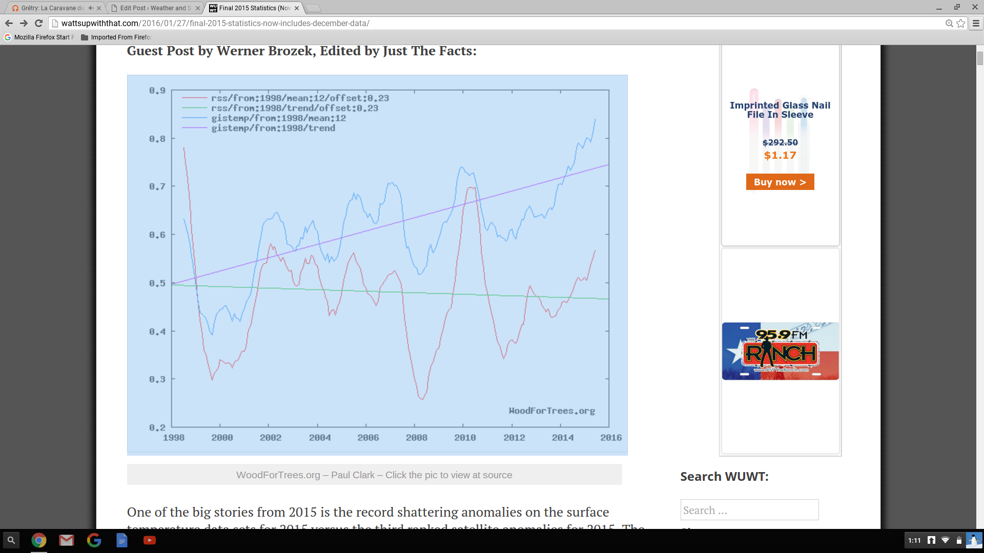
Satellite data doesn’t support the agenda.

Odds and Ends

Monday, 1/24/16

Such arrogance

I saw in Saturday’s paper that the National Weather Service, in commenting on Friday’s (lack of) snow, said that the storm had “underachieved.”  I was dumbfounded!  They didn’t blame the lack of snow on a bad forecast (it was) or on the “models” (they did a pretty good job).  Rather, they blamed the lack of snow on…nature itself!  Nature doesn’t make mistakes, it always does what the physical laws dictate.  So, what happened was EXACTLY what nature intended.  The storm neither “underachieved nor “overachieved.”  It achieved exactly what it was supposed to.   When you look at the snow left behind over the eastern U.S., it is hard to say the storm “underachieved.”

Unfortunately, such arrogance runs rampant through many of our government science-oriented agencies.  From NOAA, NASA, EPA and all the way up to our scientifically gullible President the thought exists that we (mankind) have to stop nature RIGHT NOW!  If we don’t, the planet is going to kill us all.  Nonsense!!!  Who’s to say what the Earth’s average temperature should be?  Our climate always changes, has been for millions of years.  Warm spells, ice ages…it hasn’t mattered.  Life goes one, but it, too, changes.  Estimates suggest that about 97-98% of all the species that have developed on Earth are now extinct.  (Anybody ever hear of a man named Darwin?)  In more recent times, we believe Earth was warmer than now around Biblical times and again for 300-400 years centered around 1050.  Then we had the “little Ice Age” which ended in the mid 1800’s.  Since then, we’ve had an irregular, slow warming.  Over the past 100,000’s of years, what have humans done to survive?  They have adapted to the changing climate.  Or, perhaps a better word to use is (one of my favorites) ACCLIMATIZED.  They have adjusted to the changes in climate.  Now, all of a sudden, that won’t work!  We, as the human race, must stop nature in its tracks!  Our governmental gods say it can be done and have told us how.  They seem to think that we won’t notice if our economy is destroyed and our life style is set back about 100 years, or so.  Such arrogance!

We’ve already wasted trillions of dollars for projects that have given very limited results.  Solar and wind can generate power, but at a cost two to ten times higher than traditional power. (Your tax dollars are paying for that illogical economics.)  Plus, wind and solar need backup “traditional” power supplies because that have “down” times – night and calm winds.  A far, far better use of all that money would have been to rebuild/improve our nation’s infrastructure.  But, no, say our leaders, we can stop nature.  Good luck with that.

But, a happier note (maybe)

Although we humans have greatly altered and changed nature in our time on Earth, nature doesn’t really care.  It just follows the new rules and keeps on going.  The current El Nino has warmed Earth this past 6 months and will ease only slowly over the next 6-9 months.  Meteorologists who study Earth’s climate have studied and observed how climate has shorter term cycles in the weather/climate cycle that the current scare- mongering climatologists ignore.  They say the items are insignificant and are not included in any of the climate models predicting doom and gloom.

Many meteorologists (myself included) believe that plots of two of the items show a much higher correlation to reality than any climate computer model currently used.  Based on these items (ocean currents- major and sunspots- minor), we believe that Earth’s temperatures are due for a return to cooler temperatures after the current El Nino ends (late spring).  The ocean currents and low sunspot numbers, we believe, will provide a cooler Earth for the next 10 to 20 years

Just can’t let this go by…

From yesterday’s CJ…Charles Barkley on Chicago Bulls’ Jimmy Butler…

“Other than LeBron James, he’s been the second-best player in the Eastern Conference all year.”

(As a person who made a living ad-libing, I know how easily this can happen.)


OMG OMG OMG

6 P.M. Fri 1/22/2016

I am flabergasted at the new NWS forecast…just cannot believe it.

A few more tenths of an inch possible before this wraps up by 7-9 P.M.  But, we’ll see plenty of blowing and drifting snow tonight.

3 P.M. update

Friday, 1/22/2016

Snow intensity is winding down. but periods of light snow should continue until around 7-8 P.M. Radar shows the northern edge of the light snow is slowly drifting from southern IN toward Louisville.  It’s going to be tough to measure from here on out because of the strong winds and blowing snow, but any additional accumulations will be less than one inch for the Louisville area.

Snow totals appear to be highly variable, but nothing extreme.  At SDF the snow depth was measured at 7 A.M. and showed 3″ and at 1P.M. the snow depth was also 3″.  My driveway had 2.4″ around 1 P.M. and little snow since then.

It’s hard to imagine the NWS is still maintaining the Winter Storm Warning and the 4″-6″ snow forecast for Louisville.

But then, as Yogi Berra famously  said, “It ain’t over ’till it’s over.”

Snow is here – how much?

Friday a.m. 1/22/2016

Updates and adjustments

This morning’s computer runs have continued the southern route, even more than I thought.  Nevertheless, snow has been coming down prettily for the past couple of hours.  The other, more significant, change is the increased forward speed of the storm.  According to the models, the primary energy is already pushing into the Appalachians.  Heaviest bands of snow, etc. have already pushed east of I-75.  That means the 8″-12″ snows expected south of Louisville toward Bowling Green will probably not materialize.  But, 12″+ plus still looks like a good bet over southeastern KY.

With the primary energy pushing eastward so quickly, that will shorten the time we’ll be under a moderate snow cover.  Last night, the target time for the heaviest snow was expected to be between Noon and 6 P.M.  Now, the models are pointing toward the best chance for heaviest snow to  be ending by 1 or 2 P.M.  After that we’ll see mostly light to occasionally very light snow through early evening. Snow should be ending by 7-8 P.M.

Radar trends are already showing diminishing trends to the snow locally.  That should hold through the afternoon.  Even though this is a huge storm system, with the primary energy production moving east, we’red stuck with the leftovers.  Still plenty of moisture left, but for us the dynamics to produce heavy snow are weakening.

But, I have revised my forecast for snow upward a bit.  Louisville area should see an accumulation of 2″-4″

More in a few hours.

Has Goldilocks left the forecast?

Thursday afternoon, Jan. 21,2016

(update to get my fairy tale character correct.  Who knows, maybe this whole blog is a fairy tail.  TW)

In my years following major winter storms, I’ve noticed they bunch into two major storm tracks.  One I’ll call the northern track the other will be the southern track.  The most common for us is the northern track storm which forms east of the Rockies, slides into Texas then curves northeast.  Quite often these come right up the Ohio Valley.  That sends the heaviest snows over central and northern Indiana while we’re left with some snow changing to rain.  The southern storms form over southeastern Texas then move ENE across the Gulf States.  The northern edge of these sometimes spreads precipitation as far north as the Ohio River.  Often the snow only reaches into southern KY.  The long-term climatology of the area shows these two storm tracks account for a huge majority of our winter storms.

Once in awhile, we get a “Goldilocks Storm”.  One which takes a track roughly halfway between the two favored tracks. These have been big snowmakers.  Remember last March?  Goldilocks Storms require everything (for us) to be “just right.”  Early this week, it looked as though Cinderella was going to pay us a visit.

Things changed yesterday (check yesterday’s blog for more details) when the models started shifting toward a more common southern track.  Today’s runs have solidified into a traditional southern storm – the GFS and NAM are in remarkable agreement.  This is a very large storm, so there is still a good chance that snow will move into northern KY/southern IN.

What to expect.

1). The southern half of KY can still expect some major icing late tonight changing to snow tomorrow morning.  Heaviest snow accumulations(6″-12″)  will occur over southcentral KY then SE KY, southern WV and VA.

2).  Louisville area.   Snow should not arrive here until late morning.  If we’re going to see any heavy snow it’ll be between Noon and 6 P.M.  Snow will taper to flurries during the evening.  Along the Ohio River and 20 miles south of the river snow accumulations should run 1″-3″ .  Accumulations increase rapidly south and southeast of Louisville (E’town, Bardstown, Lex should be 4″-6″.)  Accumulations over southern Indiana will be small and not get too very north of the river.

So, that’s the way I see it shaping up now.  It’s subject to change, of course.  Tonight’s runs may change things again.  And, don’t look for any hope from the European and Canadian models.  They are farther south.  We’ll be lucky to get one inch if they are correct!

So, has Goldilocks left the neighborhood?  Not yet, but she has her coat and scarf on…and is heading toward the door.


How much snow?

Thursday morning, 1/21/2016

Quick update after a glance at morning GFS and NAM model runs.  The trends remain the same as yesterday afternoon’s update mentioned – the primary storm track still looks to be on a track too far south to bring the really heavy snows as far north as the Ohio River.  Things are running a little slower as snow may hold off until around late morning or Noon tomorrow. (Makes the Winter Storm WARNING going into effect at 7 P.M. tonight look rather silly, doesn’t it? )

Still looks about the same – 3″- 5″ or 6″) in Louisville area.  Rapidly increasing totals up to 6″-12 south of the metro (across central KY).  Rapid drop in accumulations north of the Ohio.

More later.

Was today’s snow just a practice for Friday?

Wednesday afternoon. 1/20/2016

Pretty, light and fluffy snow overnight and this morning left a coating of 3″ on my driveway and 4″ at the airport.  Similar totals around most of the area.  We’ve been talking about the main event this week being Friday’s expected storm, but today’s snow has raised the bar a bit.

There have been some interesting changes in the models since yesterday’s runs.  The most prominent one is that both the GFS and the NAM have dropped the system farther south.  Yesterday, they had the axis of heaviest snowfall right over the Ohio Valley while today they have the Ohio River just inside the northern edge of the snowfall shield.  There’s likely to be a sharp drop off in snow along the northern extreme of the precipitation area, so that’s a very important development.  Another interesting result from the morning’s runs is that, even though they’ve made the southern shift, the models haven’t changed their snow forecasts for us – generally 6″ – 10″.

To me,  that’s a very surprising development, one that doesn’t make a lot of sense.  There’s another problem – the storm diving over the Rockies is expected to eventually “cut off” from the main band of westerlies and drift slowly eastward and then get re-absorbed into the upper flow and become a huge east coast storm for the middle Atlantic states.  The time while it drifts over the southern states will be when it will have it’s greatest effects on us.  That drift was expected to be very slow, putting us in its path for a longer time.  The GFS is still predicting that, but the morning NAM ejects the system much quicker eastward, thus diminishing the duration of snow.

There’s no question that this storm will be able to tap into a vast supply of Gulf Moisture.  But, it seems the biggest question for us is “How far north will the moisture come?”

So, it’s obvious the Friday’s weather is still “up in the air” so to speak.  Tonight’s and tomorrow’s model runs should go a long way toward resolving the situation.  Until then, here’s my current thinking…I believe the shift to a more southerly storm track will, in general, hold.  I believe that the  GFS and NAM will come to a compromise over the evolution of the cut off low’s ejection eastward.  If it works that way, the axis of heaviest snowfall will be over southern KY/northern TN and go ENE from there.  thus the heaviest snows should fall from Nashville and Bowling Green to southeastern KY, West Virginia, northern MD, southern PA and New Jersey.  The western half of that area could see snows in the range of 6″-12″ while the eastern half could reach 12″-20″ or more.  That puts us on the northern side of the heavy snow axis, an area which should see rapidly diminishing snow totals northward from Bowling Green.  For the Louisville area, my current outlook would be in the 3″-6″ range (higher south and east, lower north and west).

That’s it for now.  I’ll be back tomorrow…probably with a completely different story.


Snow is close

11 P. M. Tuesday, Jan. 19,20016

Brief snow update

Evening data coming in is showing slightly higher precipitation totals for overnight and tomorrow morning.  Also, a slight change in timing.

Forecast update:  snow – 3 A.M. – 10 A.M.

snow accumulation:  2″ – 4″  (Louisville area)  higher totals south and west of                                                                                     Louisville.


Sunny this afternoon…blanket of white by morning

Tuesday afternoon, January 19, 2016

Little change in the outlook today.  Models have done a flip-flop with the NAM now a little stronger than the GFS.  But, the system drifting toward us remains a weak one, so the biggest question remains, “How weak?”

Did you notice this morning that even though we had a clear, calm night and temperatures were down to about 10 degrees, there was no frost on rooftops or lawns.  That’s a testament to how dry our air is now.  The approaching system is coming from the WNW, so it’s not going be able to pick up pick Gulf moisture.  Luckily, the system does have a good supply of mid-level moisture to produce snow.  Unluckily, a lot of that snow will evaporate before it reaches the ground.  As that snow evaporates, however, it moistens the lower level air.  Eventually, the snow works its way to the ground.  And, that’s the key to tonight’s snow…how much snow will be left to fall after it finally starts reaching the surface?

We’ll probably start falling aloft over Louisville before midnight, but it looks like we won’t start seeing it hit the ground until around 4 A.M.  Snow is likely to continue until about 10 A.M., so that gives us roughly six hours of snow to work with.  Unfortunately, the models show a gradual weakening of the system overnight, so the snow we are going to miss (Mid-4 A.M.) should be more than the snow we will get later (8-10 A.M.).

One more thing to consider…that cold air.  That really changes the so-called snow ratios.  Under normal conditions (temperatures near 32 at surface and slightly warmer air aloft) the usual snow ratio is 10 to 1.  (One inch of water content will produce about a 10″ snowfall.)  Very wet snows can have ratios as low as 7 or 8 to 1 while very dry, fluffy snows can reach ratios as high as 20 to 1 (or higher).  This snow will have a high ratio.  So, a little moisture can go a long way.

So, for the next 24 hours, here’s what I expect…clouds roll in this evening with virga (that’s the snow aloft) showing up overhead (as seen on radar) before Midnight.  Snow starts around 4 A.M. and diminishes by 10-11 A.M.  Total snow accumulation: 2″- 3″ for the Louisville area.  Snow accumulations will gradually increase as you go south and west of Louisville.  The western third of the state should see 4″ – 6″ of snow.

Road conditions should be very messy (snow and ice) for morning rush hour but should return to near normal for the evening rush hour.

What about that late-week storm?
Good question, if I must say so myself.  All signs are still pointing toward a major winter weather event around the lower Ohio Valley Thursday night and Friday.  Models keep making adjustments to this storm as it begins to move over the northwestern states.  It’s strong enough to create havoc from coast to coast over the next 3-4 days.  But exactly what it’s going to bring us is still a question.  But, the most recent model runs still put us in line for some major snow.  The GFS has now upped it’s forecast to 8.2″.  But as close as 100 miles south of us, the forecast is for mostly rain.  And, trying to pinpoint something like that 2 to 3 days in advance is very difficult.  It has been my observation over the years that the GFS tends to be too far south initially with these systems and gradually brings them farther north with time.  As small a shift as 100 miles in the storm track over the next 48-72 hours could change a major snow into a cold winter rain.  It’s just too early to tell.  Stay tuned.