Monthly Archives: March 2019

Astronomical Spring arrives at 5:58 this evening

Wed., March 20, 2019

Is the Equinox equal?

The Spring (or vernal) Equinox arrives this evening as the sun will be directly above the Equator at 5:58 EDT.  And, even though the word equinox roughly translates into “equal night”, that’s not exactly true.  The common interpretation for the day of the equinox is 12 hours of day and 12 hours of night.   But if you look at the sunrise/sunset table, you’ll see today has 12 hours 8 minutes between sunrise and sunset.  So, day and night are not 12-12 as most people think.

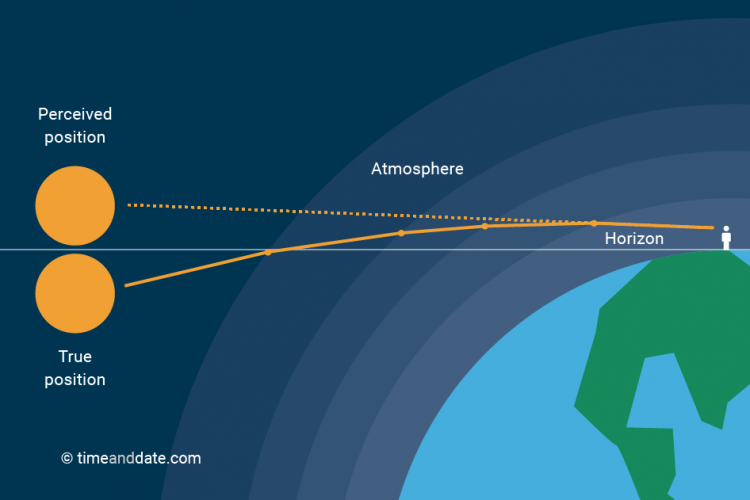
What accounts for the extra 8 minutes?  Our atmosphere! On its roughly 93 million mile journey to Earth, sunlight travels through a vacuum.  For the last 10-20 miles, however, the sunlight encounters a higher density medium (the atmosphere).  The closer it comes to the surface, the higher the density.  When light travels into a region of higher density, it bends.  This bending is properly called refraction.  Or, in the case of the sunlight and Earth, atmospheric refraction.

Courtesy: timeanddate.com

So, when we see the sun sitting on the horizon, it is actually below the horizon.  But, we still “see” the sun because the atmosphere refracts (bends) the sunlight back to our eyes.  From the time we perceive the sun on the horizon until it drops out of our vision, four minutes go by.

So, if the Earth had no atmosphere (we’d be in BIG trouble), sun rise and set would be exactly 12 hours apart.  Because we do have an atmosphere, you must add the extra 4 minutes at sunrise and four more at sunset. Thus, the day of the Equinox has 12 hours 8 minutes between sunrise and sunset

Full moon tonight

The March full moon is most commonly called the Worm Moon (think robins in the early spring).  It has many lessor known names as well…Lenten Moon,  Crow Moon, Crust Moon, Chaste Moon, Sugar Moon and Sap Moon.

Our moon will be “full” at 9:42 P.M.  Moon rise tonight at 7:38 PM EDT.

Wait, one more thing…

Just trying to wrap things up in a neat little package…

Q.  Why does the moon look much larger near the horizon than it does higher in the sky?

Ans:  atmospheric refraction (plus something called the apparent shape of the sky)                         Note:  The moon on the horizon problem is still considered as the Moon Illusion.  People have been trying to explain it for over 2000 years.  Ptolemy was one the first to try.  His suggestion was very similar to the one I gave above.  But, it’s still under debate.

A new twist

Update  5:25 P.M.

The line of storms did strengthen, but not much.  Line should push across Jefferson County without any significant problems.  East of Jefferson County, the line should be stronger, with possibly a severe storm warning or two this evening.

On the positive side, the squall line will actually decrease the strong wind fields  for an hour or two


Update  4:45 P.M.

Radar IS showing a definite uptick in strength of the approaching thunderstorms.  Between now and 6 P.M., expect a line of strong thunderstorms to move across the metro area.  Expect brief heavy downpours, additional strong gust winds and possibly some hail.


4:15 P.M. Thurs., March 14, 2019

Line of storms still crawling eastward

As of 4 P.M. the only strong-to-severe thunderstorm left is racing across northern Clark Co. IN.

Elsewhere, the remaining narrow line of storms still lies west of the Louisville area.  No severe activity has been noted in the part of the line headed our way.

The items above have worked about as expected since the weakening trend noticed a couple of hours ago.  However, we are not out of the woods yet.  One of the two short-term models predicts the line to re-intensify as it approaches I-65 and become strong again east of I-65 for a few hours this evening. That’s the HRRR model.  It’s partner, the RAP, does not.

As of this time, local radar does not show any rebuilding… yet.  If that continues and the RAP is correct, we should have minimal effects from the squall line. However, we’ll have to watch out for any intensification of the line as that would increase the potential for possible severe wind gusts – especially along and east of I-65.

WOW

I just noticed that the airport reported 61 mph wind gusts earlier this afternoon.  Bowman Field’s top gust reached 56 mph.  Ft Knox topped out at 53 mph.  Mostly likely, if we do get thunderstorms in the next hour or two, they won’t match those winds!

Timing update

2 P.M. update

Thursday, March 14, 2019

1).  Recent data shows the upper and lower atmosphere are beginning to “uncouple.”  That means the “sweet spot” of atmospheric conditions that has spawned the severe weather to our west for the past few hours is beginning to fade.

2).  The weakening has enabled the line of storms to slow its eastward progression.

3).  New “best estimate” for pushing through Louisville Metro is now 4:30 to 6 P.M.

4).  Until then, surface winds will continue to be very gusty – up to around 40-45 mph.

5).  When thunderstorms arrive, the primary threat will be strong wind gusts – up to 50 mph or so.  Tornado threat has lowered.

New time estimate

1:45 P.M. Thursday, March 14, 2019

1).  Signs  are showing the upper atmosphere and the lower atmosphere are beginning to “uncouple.”  Basically, that means that the “sweet spot” for severe weather production is fading away.

2).  The general weakening will allow the system to slow its eastward progression.

3).  Best time for Louisville now looks to be 4:30 until 6 P.M.

4).  Strong gusty winds (non thunderstorm) will continue.  Thunderstorm winds could be strong (50 mph or so), but tornado threat is lowering.

Tornado Watch


1 P.M. update

Supercells still forming over west KY into SW IN.  Several tornadoes have been reported.

Adjust time of arrival in Louisville area to 3 P.M. – 5 P.M. Otherwise, discussion below still looks okay.

March 14, 2019  Noon

Potentially Damaging Storms late this afternoon

One change since yesterday’s post is the addition of additional moisture into the equation.  The very strong wind fields are still in place.  Now with the added moisture, it looks like nature’s two primary severe weather producers – dynamics and thermodynamics – will interact for a few hours this afternoon.  Luckily for us, the worst should be over before reaching the Louisville area.

Super cells are moving along the Ohio River in western KY and southern IL.  Several warnings have already been issued.  This area of severe weather will move rapidly northeast into southwest IN and then central IN over the next few hours.  It will not affect the Louisville area.

With afternoon heating, additional super cells are likely to form.  Models continue to put the primary threat north of the Ohio River.  However, I wouldn’t be surprised to see additional development over western KY early this afternoon.  Any super cell will be capable of producing large hail and tornadoes.

The threat to Louisville area will be between 4 P.M. and 7 P.M.  as a scattered to broken line of thunderstorms moves through.  Primary threat by that time should be strong winds, but depending upon how things evolve over the next few hours, it could get worse (or better).

Updates to follow…

Severe Storm “potential”, take 3

Wed., March 13, 2019  6 P.M.

Thunderstorms likely tomorrow

This is the third time in recent weeks that the Storm Prediction Center(SPC) has put us in an area of potential severe storms.  We are in a “slight risk” region tomorrow.

The first two times, the situation was the same.  Very strong dynamics (wind fields) but little support from the thermodynamics (heat and humidity).  As the old song goes, it takes two to tango.  Both times, the partnership never happened, so the weather didn’t get to dance.

As is common in the early spring, the (almost) same situation exists again.  But, there are some differences.  Strong dynamics (upper winds, strong surface storm) are once again the prominent feature.  But, the dynamics over the midwest/Ohio Valley will be weakening through tomorrow.  Northward flow of heat and humidity is currently strong, but it also is expected to weaken.

So, overall the threat for severe storms over KY and southern IN tomorrow looks pretty small.  The GFS is weak with storm development while the NAM is a little stronger and more in line with the SPC ideas.  However, it keeps storms pretty weak over KY, but does point out a stronger threat over the northern two-thirds of IN tomorrow afternoon.

Here’s my forecast:

Mostly cloudy and breezy tonight…low…58.  70%  chance for showers and/or thunderstorms after 4 A.M. continuing into mid-morning.  (Rain/storms will be most likely along and west of I-65.)

Another area of showers and thunderstorms will likely cross the area between 4 P.M. and 7 P.M.  tomorrow.  Gusty winds around thunderstorms, but severe weather threat is quite low.  Cooler weather arrives Friday.

Stuff

Tomorrow is Pi Day.  3.14 on the calendar.  Use some math, it won’t hurt (much).