Monthly Archives: January 2019

Transition to warmer weather is underway

Thursday, Jan. 31, 2019

Possible light snow tonight.

The last Alberta Clipper for awhile (for us) will race across Il and IN into Ohio by early tomorrow.  This one continues to show up pretty weak, but will put down a swath of 2″-4″ snows across northern parts of IL, IN and Ohio tonight.

Clippers have been an almost daily feature recently.  I’ve pointed out that it’s rare to get precipitation south of the surface path of the clipper.  An exception was the small amount of rain earlier this week.  That clipper was much stronger than the current one.  As warmer air moves northeastward into the Ohio Valley tonight, it may squeeze out a little snow.  Then, again, based on our position relative to the clipper, history isn’t too fond of that idea.

The models’ stories

Both the GFS and NAM run about 50-50 on the chance for a measurable amount of precipitation.  Overall, the NAM is a little more aggressive toward snow.  The ultra short term models (HRRR and RAP) are drier.  Neither one predicts a measurable amount of precip. but both do open the door for a dusting of snow.  Also, neither the HRRR or RAP predicts rain tomorrow – contrary to the ongoing NWS forecast.

And the winner is…

The HRRR and RAP have outperformed the bigger GFS and NAM during the recent cold weather outbreaks.  This will be that last clipper for awhile as the upper air parent trough is shifting eastward to allow for warming trend.  Meanwhile, I’ll stick with the little guys one more time.

Clouds increase tonight and temperatures slowly rise into the mid to upper 20’s.  If anything falls from the sky it’ll be snow (or possibly sleet).  Any precipitation should exit east of Louisville by 8 A.M. tomorrow.  Then, warmer air pushes temperatures into the 40’s during the afternoon.  If any snow falls overnight, should be only a dusting – may a few spots may even get a generous dusting.

Then, thoughts of snow will disappear for at least a week.

Think snow!

Stuff

Chicago’s “bean” looks great even in the snow!

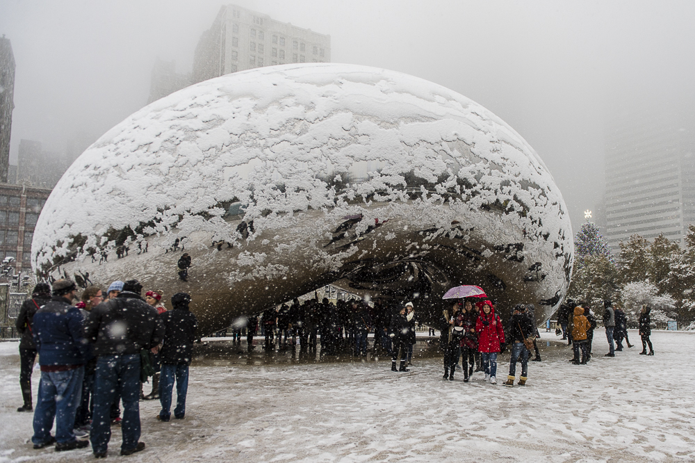
By the way, the bean’s official name is “Cloud Gate.”

Photo by Tyler LaRivieve/Chicagoist

Cold bottoms tonight

Wednesday, Jan. 30, 2019

Major warming this weekend

At least the winds have calmed.  Bitter cold air temperatures again tonight with a low  0 to -2 at the airport and most areas outside the Watterson will be below zero tomorrow morning.  We’ll see more clouds again tonight keeping temperatures from dropping too far below zero.  Could be a snowflake or two, but no accumulation this time around.

Afternoon temperatures tomorrow will climb into the upper 20’s.  Models are really downplaying the weather system due in the area tomorrow night into Friday.  Current indications are for some light snow beginning late tomorrow night then changing into rain Friday morning.  Looks like not much of either snow or rain.  More on that tomorrow.

Stuff

According to Boeing, more than 80% of the world’s population has never flown on an airplane.

Snow tonight!

Tuesday, January 29, 2019

Colder air brings some snow

While most of the weather talk today concerns the minus 10 to 20 degrees below zero wind chills expected tomorrow morning, the models are getting a little friendlier toward the cold blast bringing some snow as well.

It won’t be much, but at least we’ll probably see some actual snow on the ground by morning.  The GFS likes the idea of a bit of snow.  The NAM, not so much.  Both of the short term (24 hours or less) models, the HPPP and RAP like the idea a lot.  The latest blast of Arctic air will arrive this evening.  From roughly 9 P.M. until 1 A.M. some light snow/flurries will accompany the cold air.  Accumulations along and north of the Ohio River should be from a dusting to a half-inch.  South and east of Louisville will probably range between one-half to one inch.

In any event, the winds will be over 20 mph tonight, so the snow will be blowing around a lot.  Roads will see most of the snow blow off.  If crews put salt on the roads, it will make matters much worse – lots of icy spots.

Temperatures will bottom around 5 degrees tomorrow mid morning and only reach the lower teens tomorrow afternoon.  Most of us will see near zero temperatures Thursday morning.

Another chance for light snow arrives Thursday night.

Scattered showers early this evening

Monday, January 28, 2019

Month ends on a very cold note

A cold front crossing central IN/KY now is producing scattered very light showers.  The showers will move east of I-65 by 7 P.M. Maximum rainfall should be .02″ to .03″.  Much of the area should get only a trace of rain.  The rain will exit the area several hours before near freezing temperatures arrive, so no snow is expected this time

After 7 P.M. the Arctic air pushes in to set the stage for a very cold end to January.  Tomorrow won’t be too bad as temperatures remain in the 20’s all day.  Morning low will be around 20 with an afternoon high in the mid 20’s.

Wednesday will be the coldest day with a morning low near 8 degrees at the airport but afternoon highs only in the mid teens.

Thursday starts with a low only a couple degrees on the plus side of zero, but with afternoon temperatures rebounding into the 20’s  Warming continues Friday.

Snow?

With the cold air in place we’ll continue to see chances for flurries/light snow here as weak upper air disturbances pass overhead.  At this time, it looks like our best chance for a dusting will be Tuesday night into early Wednesday

Stuff

Light pillars are rare.  They require ice  crystals and man-made light.  Enough ice crystals for the pillars to appear usually only happen with clear air and very cold temperatures –  such as sub-zero cold.  Mia Stalnacke of Kiruna Sweden sent this photo to http://www.spaceweather.com recently.

The orange pillars  are created by sodium vapor lamps while the blue-white ones are from LEDs.

Bitterly cold air by midweek

Sunday, Jan. 27, 2019

No significant snow with the cold front

Basically no change today from yesterday’s models.  Strong cold front will cross central IN/KY tomorrow evening.  Ahead of the front tomorrow, we’ll see a windy mild day with temperatures reaching the upper 40’s to low 50’s during the afternoon.  As the front crosses I-65 tomorrow evening (around 6 – 9 P.M.)  it will probably squeeze a little moisture out of the air.  A little rain is possible with the front, then as the cold air rushes in, any rain should change to a brief period of light snow.  Little, if any, snow accumulation is expected locally.  However, !-2″ of snow will be possible east of I 75 thanks to some help from the higher terrain.

The upcoming cold air mass this week has been well promoted, so it should not come as a surprise to anyone.  However, temperatures in the low single digits with wind chills below zero Wednesday and Thursday mornings will be shocking on our systems.

By the weekend, however, it looks like temperatures once again bounce back into the 40’s and 50’s.


Snow chances are not very promising

Saturday, Jan. 26, 2019

Flurries tonight, Monday night is still a possibility

We’ve had some very light flurries early this morning, after sunrise, and again this afternoon.  Still, nothing to show for the effort.  But, this evening’s clipper may give us at least a dusting.

The weak clipper has be producing very light snow across southwestern Indiana this afternoon and is moving eastward.  It’s also weakening.  Very little snow (if any) will drop south of I-64 tonight, so this system will be mostly north of Louisville.  We’ll probably see some flurries twice this evening – centered around 6 and 11 P.M.  No more than a dusting is expected anywhere near Louisville.  Low tonight in the upper 20’s and not much increase tomorrow with highs about the mid 30’s.

Monday into Tuesday

For the past several  posts, I’ve been pointing toward a strong Alberta Clipper expected to move into the western Great Lakes early next week.  Models are now projecting the primary snow chance for us Monday evening.  South of Clipper Monday, we’ll see see strong southwesterly winds and a quick warming into the 40’s.  The cold front trailing the clipper will push across central IN/KY Monday evening.  That will bring us the coldest air mass of the season Tuesday through Thursday.  Temperatures should drop to the lower single digits a couple of days.

What about snow?

Yesterday I mentioned the (to me) unusually high amount of precipitation the GFS was projecting with that front.  The weather south of clippers is usually quite dry.  Today, the GFS forecast reduces the rain/snow totals considerably.  The NAM is also low.  That seems much more reasonable to me.  But, it also reduces the snow potential to less than an inch.  It’s early, things could change.

Daily chance for snow ahead

Friday, Jan. 25, 2019

Clippers coming at a rapid pace.

Models continue to bring small clippers into the U.S. once per day through the weekend.  They all appear weak, but still could bring us some light snow.  Last night’s clipper produced nothing but clouds and tonight’s might even be able to a produce some light snow from the clouds.  But even that looks like no more than the potential for a dusting of snow.

Tomorrow night’s clipper looks more promising.  This one seems to have the potential for a small accumulation, maybe a half inch or so.

Sunday’s clipper barely shows up on the models, so it looks like an “off” evening for snow chances.

But, Monday night’s clipper looks like the real thing.  It’s predicted to be quite strong and move across Wisconsin and Michigan Monday night and Tuesday.  Ordinarily Clippers don’t produce much precipitation south of the system’s storm track.  This time, however, the GFS has focused some rain and snow along the strong cold front sweeping south of the clipper.  There looks to be a potential for 1″-3″ of snow Monday night into early Tuesday.  It ought to be interesting.

Too early to tell about the snow, but one thing looks fairly certain – it’s really going to get COLD next Wed/Thu as nighttime lows should be the coldest (by far) this winter.

Think snow!

Cold weather continues

Thursday, Nov. 24, 2019

Daily chance for flurries/light snow

Now that cold air has reestablished itself, the open question remains – what about snow?

Helping to bring in  the new cold air mass is a brisk northwesterly jet stream flow from northwestern Canada into the central and eastern U.S.  Little pockets of even higher energy move along with this jet on a roughly daily basis.  One is passing over us tonight and will bring only clouds.  If it were a little stronger, it might squeeze out some flurries or light snow.  That’s another big question.  How strong will they be?

Being small, these Alberta Clippers (as we commonly call them) are hard for the computer models to resolve well.  As of now, the system due tomorrow night looks a little stronger – some flurries and very light snow possible.  Story looks about the same for Saturday night.  The GFS especially likes the chances for light snow from a Clipper Sunday AND one on Monday night/Tuesday.

Meanwhile, it’s far too early to get a handle on Sunday and Tuesday’s Clippers.  If the Tuesday storm works out similar to the GFS model’s forecast, the coldest air of the season will follow.  We’re almost certain to get that “single digit” temperature that has been talked about a couple of times recently.  Perhaps even a trip down to near zero.  But, that’s next week – plenty could change.  Meanwhile…

Tonight

Back to current times, the clouds should hold most of the night, but skies should clear by sunrise.  Westerly winds appear likely to stay above 10 mph.  Those two features should be enough to keep temperatures in the lower teens.  Probably it’ll drop to 12-13 here in Louisville.  A few degrees colder west of Louisville since skies will clear earlier there.

Lots of sun tomorrow, but not much warming.  Highs in the mid 20’s.

Stuff

Here’s another cool aurora shot from spaceweather.com

A little snow tonight

Wednesday, Jan. 23, 2019

Rain may hang around long enough for the cold air to arrive

The slow-moving cold front crossing the region now has been an active rain-maker for KY/IN.  As mentioned before,  the main part of the cold air won’t arrive until tomorrow.  Meanwhile, the models have slowed the tail-end of the precipitation by 3-5 hours since yesterday.  That should give time for the slowly advancing cold air to arrive in time to produce a little snow tonight.

Current thinking is that the rain will change to snow for a short time around 10-11 P.M. tonight.  Temperatures will still be above freezing, so no accumulation is likely on roadways.  However, grassy areas may get a dusting or even a “generous dusting”, but a half-inch looks like a top limit.

Later this week

A large mass of cold air will be dominate our weather scene from tomorrow into the weekend.  The upper air flow will be from the northwest.  That usually produces an almost daily chance for an Alberta Clipper to drop south from Canada into the midwest.  Clippers are hard to predict, but this morning’s GFS indicates that our best chances to get any snow from them will be Sunday and Tuesday.  Stay tuned.

Stuff

If you haven’t seem the pictures of the rare snowfall on the Sahara Desert, just click on them in the column to the right.  They’re worth it.

Winter wonderland plus the aurora!

from Chad Blakley

Snow on the Sahara!

Tuesday, Jan. 22, 2019

Amazing pictures

I missed these photos about two weeks ago, but they are certainly worth a look.  The little Algerian town near where the snow fell has only had snow three times in its recorded history…the past two years and 45 years ago!

This is from a web site known as Earther.   https://earther.gizmodo.com/it-snowed-in-the-sahara-and-the-photos-are-breathtaking-1821884950?utm_medium=sharefromsite&utm_source=gizmodo_copy&utm_campaign=top