Monthly Archives: March 2015

Soggy weather continues

Friday afternoon (Mar 13)

It’s been a week with two very nice early spring days, but also with some very wet days as well.  The second major rain system of the week is over us now and looks like it’ll hang around until at least midday tomorrow.

One reason for the warm wet weather has been the absence of the northern (Polar) jet stream.  It has receded far north of us this week allowing weak subtropical weather disturbances to drift slowly into the Ohio Valley.  This one is more widespread and slower moving than the one earlier this week, so another large dose of rain is likely.  Our area could easily see 2″+ plus of rain before it fades away tomorrow afternoon.  So, once again, we’ll see renewed urban flooding and the larger rivers and streams will (perhaps) see a second crest this weekend and an extension of time remaining above flood stage.

The northern jet is about to reenter the weather situation this weekend.  It’s influence on us will start slowly tomorrow when it sends a batch of cooler, drier air to end the current rainy weather pattern.  The jet will ease a bit early in the week (pleasant Sun, Mon and Tue), but will send us a colder air mass by mid week and an even colder one by next weekend.  Yes, winter’s not over.

NWS Radar rain estimates.

I’ve long been amazed at how well the “rainfall total” estimates from the National Weather Service’s radar match up with the so-called “ground truth” –  the totals measured by surface rain gauges.  I was amazed again Monday, but for a completely different reason.  This time the radar estimates over the whole range of the radar were all BELOW one inch (.6″ to .99″ range).  However, the rain gauges at the airport and Bowman Field both recorded about 1.5″.  So, actual measured values were more than 50% higher than radar estimates!  Something is waaaay off.  I don’t know why, but I do have a theory.  The algorithm  currently being used by the radar is probably designed for winter weather.  In the winter, in rain/snow situations, radar will often display an area of high reflectivity.  That looks like an area of heavy precipitation.  In reality, what it is usually “seeing” is a region where snowflakes are melting as they fall toward the ground.  Thus, you have snowflakes surrounded by liquid water.  The radar interprets that as huge raindrops – thus assuming heavy rain which creates an artificially intense radar return.  The common term for this is bright banding.  So, the winter radar algorithm makes allowances for this bright banding and reduces the “radar detected precipitation” accordingly.

However,  in a warmer situation when the freezing level is far above us (like the two rain situations this week), radar echoes displaying the same levels of intensity as winter “bright banding” are, in fact, measuring just what they seem to be – heavy rain.  Thus, using winter schemes during a spring rain will greatly reduce the “radar detected rainfall.”

Now, this seems like a problem with an easy fix – change to the correct algorithm.  Evidently, however, my theory must not be correct.  Because it’s happening again today!  As of 5 P.M., radar rain fall estimates for an area roughly 40 miles around Louisville showed about 75% of the area rain totals below .30″ while the other 25% have had between .30″ and .59″.  Meanwhile, SDF and Bowman Field (LOU) rain gauges were reporting between .70″ and .80″ of rain so far.  But then, what’s that old line – Fool me once, your fault.  Fool me twice, my fault.?

Very unusual Pi Day tomorrow.

Within the past two decades or so, math and science oriented people have thought that the very important math symbol “pi” should get some credit.  pi’s value is 3.14…, so March 14 or 3/14 is celebrated annually as “Pi Day.”  But, tomorrow is an extra special version of the day – it will not be repeated for a 100 years!  Going out a few more numbers in the value of pi we get 3.1415…  3/14/15 is tomorrow’s date.  Then the next three numbers of pi are 926.  So, tomorrow at 9:26 A.M. and 9:26 P.M. we’ll have the following number string – 3/14/15 9:26  The most digits of pi you’ll ever see on Pi Day (unless you live a very long time).  And, if you want to go to seconds, the next two numbers are 53.


    Now, that seems to be a problem with an easy fix – change to the correct algorithm.  Evidently, however, my theory may not be correct.  Because it’s happening again today!  As of 5 P.M., Radar estimates within 40 miles (or so) of Louisville showed about 75% of the area with rain less than .30″  and the rest of the area in the .3″ to .60″.  However, both airport rain gauges in Jefferson Co.  were reporting totals between .7″ and .8″.


Warm, wet week ahead

Monday Afternoon (Mar. 9)

The polar jet has disappeared for awhile, so the cold air will stay far north this week.  The Subtropical (Southern) Jet rules the week ahead.  This jet is far weaker than the Polar Jet, but does have its foot in the Gulf of Mexico, so plenty of water is available.

Rains today over the south-central U.S.  will ride the jet slowly northeastward tonight.  Rain should begin after midnight and continue off and on most of the day tomorrow.  As this system is short on energy, no excessive rains are likely.  The NAM puts us around 1.5″ of rain but the GFS pushes the heaviest rains over southern KY.  Although the NAM placed the rain and snow last week almost perfectly, I feel the GFS looks more realistic with the weaker system.

Looks like Wednesday should be dry and warm.  Temperatures should reach at least 60, but any 3-4 hour break in the clouds could push us to the mid to upper 60’s.

Thursday’s weather looks very questionable at this time.  The NAM wants very much to bring another of northward, much like tomorrow.  Meanwhile, the GFS pushes the moisture eastward during the day and then brings some rain northward to Louisville Thursday night into Friday.

Milder for the weekend; warmer next week

Friday afternoon (Mar 6)

After a beautiful snow forecast, the NWS fell back into it’s recent trend of big-time errors on low temperatures.  Early yesterday, it was all about the record lows we’d be having.  Didn’t happen.  Didn’t even come close.  But, in fact, a record MAY have been set!

First, yesterday’s high, predicted to be 17, reached the mid 20’s.  But the crowning event was to be the low this morning.  (see yesterday’s blog)  Yesterday’s overnight forecast, issued at 3:41 P.M. predicted a low temperature of -5 to -10 degrees.  This morning’s low was 8 deg. ( In forecasting, an error of +/- 3 degrees is considered a “hit”.)  So, the official forecast had an error range from 13 degrees to 18 degrees!  In today’s world, a miss of 10 deg. or more probably only happens a handfull of times a year.  But, a miss of 18 deg. is  virtually unprecedented.  So, indeed, a new record may have been set this morning – worst low-temperature forecast ever.  However, I don’t imagine that such records are kept, so we’ll never know.

Weekend

Southerly winds and partly cloudy skies will contribute to dry, warming weather.  That’s good news for most of us, but not for those who live in flood-prone areas.  Highs in 40’s may sound good, but that’s still below normal for early March.  Next week we’ll have some days in the 50’s and some reach the 60’s.

Tonight…partly cloudy and cold…low near 20 this evening, then slowly rising temperatures overnight.

Tomorrow and Sunday:  partly cloudy with highs in the mid to upper 40’s.

Cold night ahead.

Thursday Afternoon (Mar 5)

“Oh, what a beautiful morning; oh, what a beautiful day.”   (from “Oklahoma”)

Just about the only thing that makes me feel better after such a poor forecast is the ability to really enjoy what nature has provided for us.  Those of you who take a more negative view of snow, don’t worry.  March sunshine can eat up snow in a big hurry.

So, now the weather attention turns to the cold air/snow cover combination which can sometimes lead to some extremely cold temperatures.  In a similar situation to a few weeks ago, the NWS is predicting some really cold readings for tomorrow morning (-5 to -10).  Forecast model guidance is once again significantly warmer than the forecast ( 13,10 and 4 deg) are their most recent forecasts.  True, conditions look good, but this air mass is not as cold as that one was.  If skies clear for most of the night, as is expected , near zero lows are likely, but -10 appears unlikely except in some rural areas.  I’ll stick with a low of 3.

If skies clear this evening…

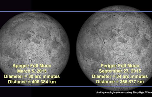
Tonight is the night of the mini moon.  Each year we hear of the giant or super moon when the Earth-Moon distance is the smallest of the year.  But, if there is a Super Moon, there must be an opposite full moon when the Earth-Moon distance is the greatest.  That’s called the mini Moon – when the full moon is smaller and dimmer than any other full moon of the year.  Tonight’s the night.  Look east around sunset if the clouds are gone.  See if you can tell the difference from other full moons.

minimoon_strip

image from Alan Dyer of Silver City NM

Snow diminishes overnight

Wednesday 11 P.M. (Mar 4)

Just measured the snow in my driveway – 5″- and heard that the airport has already hit 7″ so I guess I’d better try to repair my “blown out of the water (or snow) forecast”.  Models and radar indicates that light snow should continue until 1 or 2 A.M. with only minor accumulations after that.  Snow banding has been heavy just south of Louisville so I’d expect areas from southern Jefferson Co., Bullitt, Spencer, Shelby, Hardin, Breckinridge, Grayson, Franklin, Nelson and Mercer getting Double Digit snows (10″-13″).  Lower totals over the rest of Jefferson Co. and areas north.

We should get about 1″-2″ for the rest of the storm, so 6″ to 10″ looks good over the area north of the counties mentioned above.

You win some, you lose some, but there’s tomorrow to try again.

Snow chances looking up…but how far?

Wednesday Afternoon (Mar 4)

After looking over the most recent data, I feel like some changes are in order.  First of all, I was expecting a much longer period of sleet.  That didn’t happen, so less sleet means more snow.  More snow than sleet creates a deeper accumulation.

Second, the models have increased the amount of expected precipitation between now and midnight.  That, too, would lead to a little higher snowfall.

So, with those changes in mind, here’s my latest forecast:

Tonight:  snow likely, windy and cold…low…17.  Most of the snow should fall by midnight…about an inch or less after midnight.  SNOW ACCUMULATION:  3″ to 5″

Tomorrow:  Mostly cloudy in the morning, then partly cloudy.  Windy with a high near 24. Some snow flurries possible in the morning.

Tomorrow night:  very cold…low…near 3.

More sleet than snow?

  Wednesday 11 A.M (Mar 4)

I see the Weather Service has started to back down on their snow forecast, so I suppose the media folks will as well.  However, I still think the NWS step backward is far too small.

Quick look at morning data runs confirms (to me anyway) that my forecast posted last night is right (almost) on target – 2″-4″ of snow/sleet by tomorrow morning.  However, I have one subtle change to make.  It looks to me that we’ll see a prolonged period of sleet this afternoon.  We could see up to an inch (or so) of sleet before a change to snow this evening, probably between 6 P.M. and 9 P.M.  After midnight, snow should begin to taper off to a few flurries by morning rush hour.

Another update this afternoon.

P.S. Why is JCPS closed today???

Big changes to forecast!

Midnight/early Wed (Mar 4)

Evening update showing some changes, mostly due to the continued “slowing”   of the models.  In essence, it now looks as though the snow shouldn’t begin until after the primary moisture source has passed by.  Thus, much less snow is likely than  currently being predicted.  My revisions  to my earlier forecast…

Overnight:  rain, perhaps heavy at times.  Minor urban flooding expected for rush hour. Temperatures falling into the 30’s

Morning: Rain likely probably changing to sleet by midday.

Afternoon:  Sleet likely.  Accumulation 1/2″-1″.  Sleet changes to snow by evening.  Temperatures falling into the 20’s during the day.

Tomorrow night:  snow, windy and cold…temperatures continue to fall.  Snow diminishes toward morning.

TOTAL SNOW/SLEET ACCUMULATION:  2″ TO 4″

Big snow (probably) on the way

Tuesday afternoon (March 3)

Weather patterns remain pretty much the same as yesterday (see March 2 blog), but the NAM’s much slower evolution of the weather pattern has definitely been the way to go.  In fact, the GFS has slowed to about match yesterday’s NAM while the NAM has slowed even more.

That may not sound like a big deal, but it is huge concerning potential snowfall tomorrow and tomorrow night.  One other major point mentioned yesterday is the continued lack of any “kicker” out of the cut-off southwestern trough.  That allows it to send in one more big chunk of moisture WITHOUT any significant energy to form a strong surface low along the cold front.  (A strong low moving along the front would kept warmer air here much longer than now expected.  Thus, snow expectations would have been much lower.

But, the big picture hasn’t changed much – heavy rain expected tonight.  Rain totals could range as high as 2″ to 4″ before the changeover  to snow.  The NAM still keeps the axis right along the Ohio River while the GFS continues to place Louisville on the northern edge of  the heaviest rain area – with the heaviest rain axis about 60 miles south of the river.  Either way, we’ll probably have a major water mess for rush hour tomorrow.

Now, the snow potential.  In spite of the timing differences between the NAM and GFS, they are a lot closer together with the potential snowfall.  Without explaining all the different scenarios from the models, I’ll just go right to my  current “working theory.”

CURRENT FORECAST IDEAS:  Heavy rain and widespread moderate urban flooding tonight.  Temperatures begin falling after midnight and and reach the 30’s by 7 A.M.

Tomorrow morning  rain changes to sleet, which should continue until at least mid-afternoon.  A change to snow is likely by late afternoon.

Tomorrow night:  SNOW, probably heavy at times through the evening and early morning hours.  Any significant snow should be over by 8 A.M.  Light snow/flurries could continue Thursday.

TOTAL SNOW ACCUMULATION:  6″ to 10″ for the Louisville area.  lower totals north of Louisville and heavier snows south of Louisville.

NOTE:  My prediction is based on the expectation of at least several hours of sleet tomorrow.  If the change to snow occurs sooner, snow totals could reach 8″-12″.  (The most recent “new” GFS model says 7.6″.

Another complicated snow forecast

Monday afternoon (March 2)

The very heavy rains expected tomorrow and especially tomorrow night have been long advertized and they should happen.  Earlier rain estimates suggested 2″-3″ for the Louisville area.  Most recent forecasts are pushing totals even higher, more like 3″ to 4″.  Either way, we should be prepared for a lot of lowland flooding tomorrow night/early Wednesday.  It looks like we’ll see quite and mess with the excessive rainfall.  Overall, the NAM is a little slower with the timing of this system (heavy rain potential continues until at least midday Wednesday.  The NAM continues to focus the heaviest rain right along the Ohio River and about 75 miles north and south of the river.  Meanwhile, the GFS is faster with any heavy rains over by midnight tomorrow night.  The GFS also places the axis of heaviest rain south of Louisville – over central KY with Louisville on the northern edge of the 2″ + zone.

For several days those heavy rain forecasts have come with a tantalizing suggestion that the rain will turn to snow before ending.  As we’ve drawn closer, snow is looking like a very good possibility.  As I mentioned last week, the key to this part of the forecast was whether the southwestern U.S. upper trough would phase, and merge, with the stronger northern system.  As expected, rather than merging, the southwest system “cut-off” from the main system.  As a result, there will be no strong surface low at the end of this winter storm.  Just frequent ripples of energy, but no strong center of the storm system to dominate the action. But the SW system will provide ample (more than ample) moisture to the northern system’s energy.  Thus our threat for flooding rains.

But with no strong energy surge to come along and clean things out, it greatly enhances our chances for snow.  In fact, it is settling into a rather classic pattern that usually puts down  a 1″-3″ snow cover as cold air changes the rain to snow for the last few hours of precipitation.  As wet as the storm looks to be and as cold as the air is behind the cold front, it could easily jump up a notch to 2″ to 4″ of snow.  Big question, however, is where is the snow going to accumulate with all the water all over the place?

So, trying to smooth out the variations between the models, here’s my latest forecast:

Tonight:  Increasing cloudiness and cold.  Temperatures rising into the upper 30’s by morning.

Tuesday:  Warmer, with light rain developing during the morning.  Rain will become heavy at times during the late afternoon.  High…53.

Tuesday night:  Rain, heavy at times.  Widespread minor flooding likely.  Temperatures rising to the upper 50’s, but then falling after midnight into the low 30’s by morning.  Rain changes to snow overnight with a possible accumulation of 2″ to 4″ by midday Wednesday.