
Wed., Jan 22, 2020 4 P.M.
Flip flops are the latest model fashion
Two weeks ago, the models were forecasting a major pattern reversal over North America. Winter was finally on the way. Seven days ago, the models had reversed themselves – abnormally warm weather would remain well into next month. Now, the models have undergone a “reversal reversal.” In other words, the forecast again favors below normal temperatures taking over during the next 7-10 days. This time, however, the Euro model is even colder than the GFS.
It’s all very confusing, but here’s what’s most likely for the next few days. A deepening upper level low will push from the southern Rockies tonight to a position right over top the IN/KY by late Friday. Ahead of the storm we’ll be mild with periods of rain from late tomorrow into Friday. As the low moves over us rain showers will probably change to snow showers Friday night into Saturday. It’ll be too warm for any accumulation on roads, but some minor accumulations are possible on grassy areas.
After that, warming will be back early next week followed by rain, then colder. GFS and Euro predict another storm with rain to snow next Fri/Sat, but forecasts that far in advance this winter have met with pretty poor results. We’ll see.
Thursday, Jan. 16, 2020
Not again?!
Today’s GFS is really cutting back on its pattern-reversal forecast. Today’s runs push any cold phase arrival back a week, at least. It’s quite a bit weaker than last weeks storm, but another west coast storm is developing and heading toward a northern cut across the central U.S. Saturday. Following that, Sunday thru Tuesday will be the coldest days we’ve seen in almost a year.
That was supposed to be start of a long term cold period. But, now the GFS is predicting yet another major west coast storm moving into the central Plains the next weekend. Even after that, it’s holding off on a pattern shift.
The Euro model has been a little hesitant on the magnitude of any pattern change for the past week. Now, it too is backing off.
The GFS has been doing this to us for six months. I’m still hoping that one of these times, it’ll actually happen.
Wed, Jan. 15, 2020
This morning’s showers surprised me as I thought the return to warm air would be dry. But the yoyo weather will continue – warm today, colder tomorrow, and warmer with periods of rain Fri/Sat. Then, Sunday wintry weather arrives. We’ll see below normal temperatures for at least a couple of weeks. The GFS has lost the weak clipper system it was earlier predicting for Tuesday night. Now it’s developing a snow to rain event for Wednesday night and Thursday. Updates will follow.
Australian Fires
Due to geographical location, global wind patterns and ocean currents, the West Coast of North America and the East Coast of Australia are both prone to seasonal forest fires. This is nothing new – it’s been going on for thousands of years. Many are putting the blame for this year’s higher than normal fire destruction on “climate change.” Good try, but climate change has been going on forever, just like the fires. Might other things be involved? Of course.
1). Forest maintenance – Like the U.S., Australia bans removal of undergrowth from forest floors. Undergrowth removal eliminates the majority of the fuel for fire growth and rapid spread. Seems to me that undergrowth removal should be priority #1. But, it’s banned. The result is more fires, much more land burned, rapid spread of fires, more wildlife and human deaths… (But, it keeps some environmentalists happy.)
2). Population – Since 1950 Australia’s population has jumped from around 8 million to about 25 million today. As in the U.S., Australians have built many homes in forested areas amplifying the potential death and damage fires can create.
3). Humans- So, we’ve got forests primed to ignite, and many more people living in them. Then you add in the fact that humans are pretty careless. In the U.S., an estimated 85% of all forest fires are caused by humans. I’m guessing it’s about the same down under.
4). Malicious humans. A large number of forest fires are intentionally started by arsonists. U.S. numbers say 21% of our forest fires are arson. As of yesterday, about 155 people have been arrested on arson charges in Australia. An additional (approximately) 300 have been arrested for fire-related offenses.
Forest fires have been occurring for as long as Mother Earth has had forests. Climate change has been happening even longer than that. But, since we homo sapiens arrived about 200,000 years ago, life for forests has become much more hazardous.
Note: The graph below portrays the areal coverage of Australian fire damage for the past 100 years. This year (so far) ranks #3, but 1975 was ten times higher than this year!
Note 2: In 1975 the big climate issue was global cooling and the beginning of the next Ice Age. So, I wonder if that year’s fires were blamed on that.
Note 3: One hectare equals 2.47 acres.
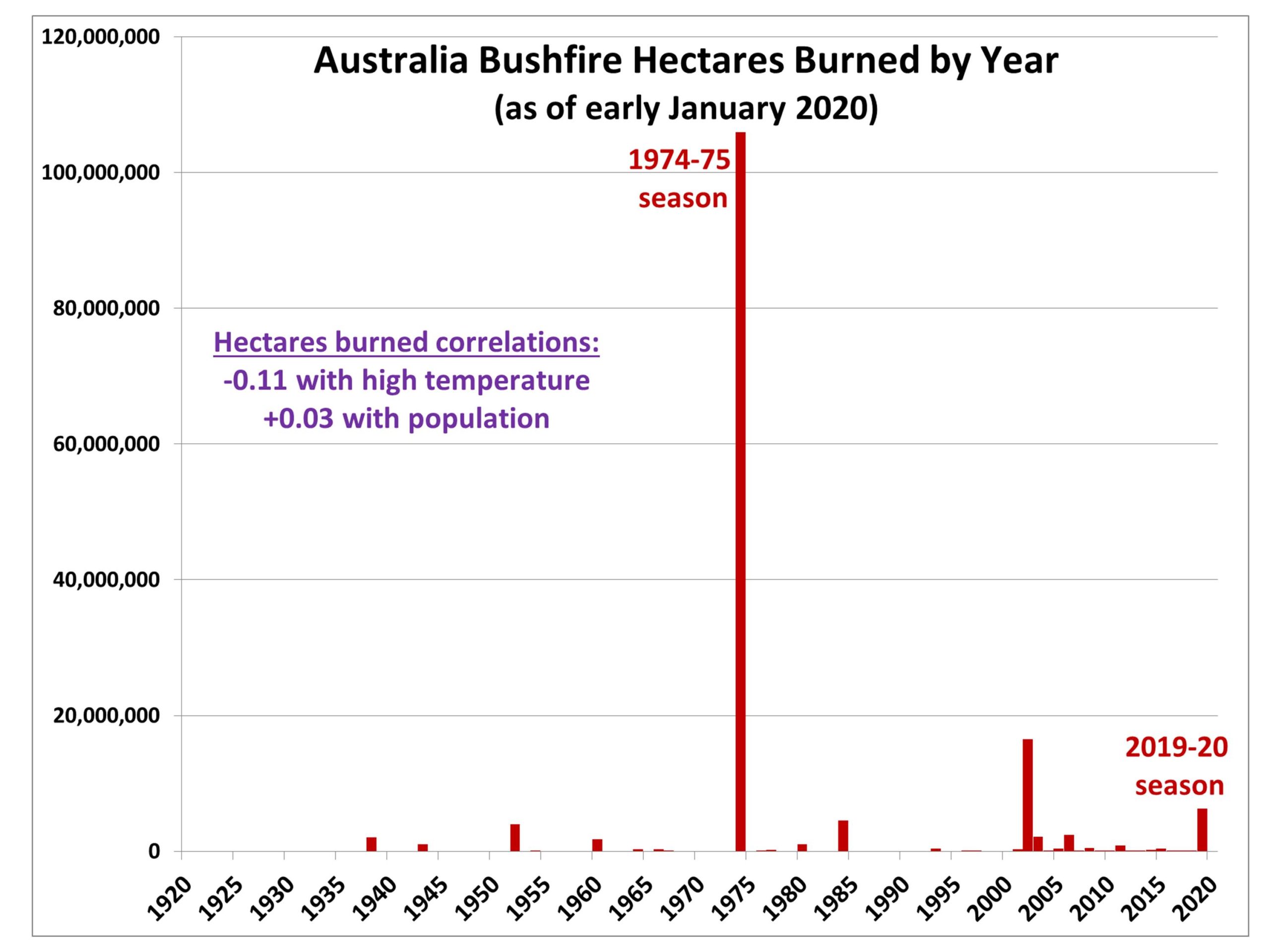 Fig. 1. Yearly fire season (June through May) hectares burned by major bushfires in Australia since the 1919-20 season (2019-20 season total is as of January 7, 2020).
9 P.M. Tuesday, Jan. 14, 2020
Mild weather continues a few more days
I don’t know how many times over the past six months, our forecast models have predicted a reversal in the upper air pattern over North America, but it’s been often. Only once (November) did it actually happen. Now, it’s seems like it will reverse for a second time, starting Sunday.
The shift to west coast ridge/east coast trough is underway. The strong northwesterly winds aloft will definitely put us into below normal temperatures. When pattern reversals occur, they generally persist at least 2-3 weeks. But, this has been unusual winter, to say the least. When the “cold phase” hit us in November, it lasted about 3 weeks before the “warm phase” took over. And the warm phase has been around ever since. Since November 25, we’ve only had six days with below normal temperatures. For those keeping score, that’s 45 above normal days and only 6 below.
So, are we going to have a “3 week” winter, or will be longer? Good question. Answer unknown.
Old rule of thumb: After 3 weeks, if the upper air winds over us are stronger than when the cold regime began, it will persist another 3 weeks. If the winds are weaker than originally, the warm regime will return quickly.
Rest of this week
Official forecast gives Louisville a chance for rain tomorrow. I’m not buying that although some light rain will be possible over southern KY.
Another midwestern storm is likely late Friday, but it’ll be much weaker than last week’s storm. We’ll probably see periods of rain from Friday into Saturday.
Then, winter arrives Sunday! Next chance for snow comes from a weak clipper next Tuesday.
Saturday, Jan. 11, 2020 1:30 P.M.
Potential damage area moves east.
After following this storm system for a week, I still didn’t get it right. The rain and heavy downpours arrived long before I expected them to – the heaviest rain passed through Jefferson County between Noon and 1 P.M. Also, in spite of the rain acting as a break, wind gusts reached 50+ mph in a few spots. Surprisingly, the number of power outages locally are less than 1000 customers. Even an average spring/summer thunderstorm produces many more than that.
So, overall, the system proved to be a pretty typical midwestern winter storm for us.
This afternoon, the rain will continue, then fade away around dark. The winds have been silenced for awhile. They’ll get stronger again as the rain ends, but top gusts tonight will be in the 25-35 mph range. They’ll be pushing colder air across the Ohio Valley, but nothing unusual for January. In fact, tomorrow’s temperatures will remain above normal.
Heavy rain, strong winds tomorrow
6 P.M. Friday, January 10, 2020
A major storm system will move across the area tomorrow. We’ve seen several similar systems over the past few months and the results should be about the same as the previous ones.
But, first, let’s look back at how the forecast has evolved this week. The hype was out early – Monday I heard “potential” for 5″-7″ rains (Thursday through Saturday), major severe storms outbreak Saturday, high winds and flooding were added to the mix.
By Tuesday, the rain potential was down to 3″-5″, but all the other dire circumstances were still in play. Wednesday, the rain potential forecast was down to 2″-3″ and rain for Thursday was out but still a 90% chance for rain Thursday night and Friday. The bad-news vibe for Saturday was still there. Wind gust forecast was now up to 50-55 mph.
Thursday was a nice day, but the bad news would start Thursday night – it didn’t. But, Friday would be a rainy day setting the stage for Saturday’s deluge. Also, the rain forecast was now down to 1″- 3″.
Friday. The total rain forecast is now down to 1″-1.5″. Wind gust forecast is still calling for a few gusts to 45 mph in Louisville area. My current forecast expects a few showers in the area until 10 P.M. followed by dry windy weather later tonight through tomorrow morning.
This is a good reminder about the scourge of hype that has infected meteorology and the media. This is not new – there was plenty of it during the time I was working. It just seems to be getting worse. The same thing holds for the “climate crisis.” There is no climate crisis. So many dire claims; no verification. Supposedly, in the past 30 years, or so, 42 specific “predictions” of things that would happen before 2020 have been made. So far, none of the 42 has happened. But, I digress.
Tomorrow
Here’s what I expect tomorrow. Partly cloudy, windy and warm in the morning. Temperatures will reach a record high in the low to mid 70’s. Winds will gust into the 30-40 mph range by late morning. That’s the easy part.
The GFS has the cold front/heavy rains pushing through between Noon and 4 P.M. while the NAM is four hours later. Let’s compromise and say 2-6 P.M. During that time heavy rain is likely. Thunderstorms are possible, but a pretty low risk. Wind speeds and gusts will be lower during the afternoon than they were in the morning.
After the heavy rain moves east, winds will pick up again into the 30-40 mph gust range and temperatures drop rapidly to near 40 by Sunday morning.
Notes: The NAM predicts the center of low pressure with this storm to move/form right over Louisville tomorrow afternoon. The GFS hints at it. IF that happens, you’ll notice two results. 1). Rainfall will be less than currently predicted. Total rainfall would probably be less than one inch. 2). Winds will be weaker than expected. Morning gusts in the 25-35 mph range. Evening gusts in about the same range.
Either way, not to much to be worried about.