Monthly Archives: February 2016

Windy and colder tonight

Wednesday, Feb. 24, 2016

As the major surface low pressure area moved right over the area this morning, we actually got a break from the heavy rain and even saw some sunshine with temperatures in the upper 50’s for an hour or two.  Then, as the low moved northeast, the colder air on it’s backside dropped temperatures in a hurry…and the rain resumed.

But, we’ve seen the worst  of it now.  Winds will start decreasing this evening and the rain, possibly changing to snow, will be diminishing between 7 P.M. and 9 P.M.  After 9 P.M., light rain showers and/or snow flurries will be scattered around the area during the night.  Whether we have  rain or snow  showers doesn’t make any difference.  If it’s snow, it’ll melt on impact so there’ll be no accumulation – so it essentially makes a situation I like to call “white rain.”  It has the same impact as rain.

Temperatures should remain above freezing in the Louisville area, so traffic problems should be no worse than wet roads.

4-5 days ago the models were predicting a major cold air outbreak to hit the eastern half of the country this weekend.  But, nature didn’t seem to get the message – in reality the cold air is pushing east rather than south.  So, now it looks like a cold day tomorrow followed by warming Friday into the weekend.  Not as warm as last weekend, but still very nice for late February.

Note:    I know some forecasts floating around include the possibility of up to an inch of snow (on grassy areas), but that idea seems to me to be a real outlier.

Another near miss?

Tuesday, Feb. 16, 2016

Small clipper system has been difficult for the models to define well…until now.  As mentioned yesterday, the models had strengthened the system so that the surface reflection would pass to our south.  Today’s models are even stronger, so it now looks as though the whole thing will stay south of Louisville.  Areas west and south of Louisville will receive some some light rain this afternoon, but I’ll give it only a small (30%) chance for measurable rainfall for Louisville.

Any precipitation in KY should be south of Louisville and east of I-65 by 7 P.M.  After that, a few snow flurries will be possible tonight but create no problems.

Tomorrow will remain cloudy and cold, but sunshine returns with a nice warm up expected Thursday through Sunday.  Two or three days could reach into the 60’s.

Note:

I guess a better way to express the title today should say…Another near hit?

Note 2:

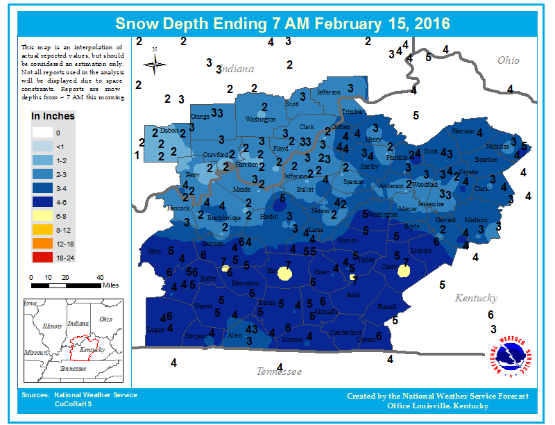
Snow accumulations from Sunday’s storm…snowd02152016c(1)

More Snow?

Monday, Feb, 15, 2016

Quick update today.  As expected, large storm gaining strength to our south is heading toward the Appalachians with plenty of snow, but mostly rain.  Southeastern KY could get some flooding rains tonight.

That system could bring some rains as far north as the Ohio River.  I’d make it about and 40% chance for rain reaching Louisville for a couple of hours this evening.  Most areas south and east of Louisville will see rain tonight.

Yet another Clipper will approach the area tomorrow afternoon.  Models can’t agree with each other with this system.  It is stronger than expected and will likely take a path south of Louisville.  That puts us in “snow territory”, but the storm will be small and weakening as it absorbs into today’s southern storm.  The result should be some light snow (possibly mixed with rain) tomorrow afternoon.  Little, if any snow accumulation is expected.  No road problems are expected due to temperatures above freezing.


Valentine’s Day weather treat

Sunday, Feb. 14, 2016  (Noon)

Everything still looks on track with previous discussions on today’s snow.  After a dusting this this morning, steady snow should be arriving by 1 P.M.  Heaviest snows  should be between 2 P.M. and 5 P.M.  Models today have been a little more generous with snow accumulations, so I’m going to increase my forecast a bit.  I now expect we’ll see a 2″ – 3″ snow accumulation this afternoon and early evening.  Snow should fade to a few flurries by 7 P.M. to 9 P.M. tonight.  Rising temperatures into the 40’s tomorrow should wipe out the snow quickly.

That third “short wave” I’ve been discussing the past few days is still going to be the biggest one.  Look for heavy snows 6″ + along the Appalachians (from eastern KY up into New England tomorrow.  That system could also bring us a little rain (especially east of I-65) late tomorrow.

Another clipper should bring us a little rain and/or snow late Tuesday.  Then, a BIG warming trend later this week!

Today’s snow…

Snow: approx.:  1 P.M. – 8 P.M.

Snow accumulation: Louisville area 2″ -3″.         The southern half of Kentucky will see higher totals.  South of the parkways should get 4″-6″ of snow, especially west of I-65.  Southern Indiana will be on the lighter side – mostly 1″ -2″, but up to 3″ near the river.

Let the fun begin!  Happy Valentine’s day!

Snow still looks likely for Sunday

Saturday, February 14, 2016

Today’s GFS and NAM have become pretty close to each other with regard to the light snow storm expected tomorrow.  And, they both continue the faster approach of the snow.  As it looks now, snow should begin tomorrow morning.  Arrival time should be between 10 A.M. and NOON.  Snow should continue through the afternoon, then diminish during the evening.  Accumulation around the Louisville area should run in the 1″ – 2″ range.  Higher snow totals are likely over most of Kentucky south of Louisville.  Plus, another Gulf coastal storm forming early Monday could add additional snow for the southern half of the commonwealth.  That storm should not effect southern Indiana or northern KY.

So, by midday Monday, accumulations of snow could reach the 4″-8″ range over southern KY while the Louisville area remains in the 1″ – 2″ range (or lower by then).  Temperatures Monday should jump into the 40’s, so any snow we get won’t last long.

Looking ahead…yet another Clipper appears on the horizon for Tuesday.  Current indications are that the surface reflection of the system will move north of Kentucky.  That puts us in the zone where not much happens.  After that temperatures should begin a major upward trend – could even reach the 60’s by next Friday.

Stuff

Monday we’ll celebrate Presidents Day.  However, there really is no “official” day to celebrate our Presidents.  The official name is still Washington’s Birthday.  But, after the 1971 act to make the three-day weekends, people have just been calling it Presidents Day.  But, it’s not!

Weekend weather outlook

Friday, February 12, 2016

Another blast of cold air is pushing across the Ohio Valley setting the stage for a very cold weekend. The new surge of cold air should bring along  some snow flurries, but just a dusting of snow is likely.  High temperatures tomorrow will only reach 20-22 but Sunday should warm to around 30.  But, the big question is whether all that cold air will be setting the table for some snow.

Yesterday, I discussed the upper level “wave train”  that would the big feature in our weather for the next few days.  (Additional details in yesterday’s post)  Wave 1 passed over the area this morning with the expected results.  Wave 2 still looks on target to the discussion yesterday…with one exception.  It now looks as though the timing of the system will be about 6-12 hours earlier thought.

So, Sunday’s outlook now looks like this:  Thickening clouds during the day with light snow beginning by late afternoon.  Periods of light snow continue overnight but ending before daybreak.  This remains a rather disorganized storm system.  Snow forecast remains in the 1″ to 2″ for the Louisville area with perhaps a little more over southern Kentucky.

Biggest changes to forecast are with the “last wave on the train.”  As mentioned yesterday, the last energy pulse is (almost) always the strongest.  Today’s models have emphasized that idea by making wave 3 even deeper that yesterday.  If this trend holds up, what once looked like a good chance for a sizable snowstorm now looks as though it’ll probably miss us entirely.  Now appears that the storm will organize over the Gulf states then head up the Appalachians as another major snow-maker for the eastern states.

As things stand now, the Washington’s Birthday holiday will be cloudy and cold with snow flurries possible – a far cry from what the models have been indicating for the past week.  Oh, well.  There’s still time for change.

Stuff

Valentine’s Day derives from an ancient Roman festival named Lupercalia.  The February 13-15th festival was a fertility rite believed to be in honor of the god of agriculture.

Series of Clippers headed our way

Thursday, Feb. 11, 2016

Clipper #1 – Tonight and tomorrow

This clipper will take a path from Iowa, Missouri into western Tennessee tonight then turn eastward tomorrow.  Very little moisture is available as the atmosphere is very cold.  Any significant snows will stay west and south of the Louisville, but the SW third of KY could pick an inch or two late tonight/tomorrow morning.  Meanwhile, the Louisville area will be on the edge of this system with plenty of clouds, but little, if any, snow accumulation.  Our best chance for snow will be between 7 A..M. – 10 A.M. tomorrow.  Some flurries could linger tomorrow afternoon.

Clipper #2  – Late Sunday into Monday morning

This clipper has more potential than #1.  We’ll see strong southerly winds Sunday in advance of the system.  That’ll warm us a bit (near 32 deg) but more importantly it’ll allow the clipper to tap into some Gulf moisture.  Nevertheless, the upper dynamics don’t look too great.  At this time, the models don’t organize the upper pattern into a single point of energy.  Rather, the energy remains rather diffuse.  Overall, it looks to have the potential for, roughly, a one to two inch snowfall.

Clipper #3 – Monday night and Tuesday morning

There’s an old saying in the forecasting world…”The last wave on the train is the strongest.”  Commonly, we call the little, fast-moving pockets of upper level energy “clippers.”  In meteorological lingo, however, they are known as “short waves” as they are little bits of energy moving along the troughs and ridges of the much larger “long waves” that circle the globe.  A series of short waves moving through a trough is called a “wave train.”

The primary long wave pattern over North America will be shifting next week into a warmer pattern.  But, not before the “last wave on the train” hits us Monday night into Tuesday.  For simplicity, I’ve named it Clipper #3.  And, yes, it’ll be far stronger than numbers 1 and 2!

This system has the potential be become a major winter storm.  But what it will bring us is an open question.  Depending upon the way you interpret the models, we could be looking at a big snowstorm (like the one that didn’t show up a couple of weeks ago).  Or, a major ice storm could be looming.  Another choice could be snow changing to rain and then back to snow on the tail end.  We’ll probably hear a lot of different “forecasts” about this storm over the next few days.  Most of them will be wrong.  It’s just too early to tell.

Revised snow forecast

Monday, 02/8/2016  5 P.M.

Quick update to adjust forecast to current trends…

The upper level low expected to move over the area this evening is right on schedule, however, it’s path now looks like it’ll stay just west of Louisville.  So, heaviest snows – an inch or so – will stay west and south of us (Evansville, Owensboro, Leitchfield, Bowling Green, Hopkinsville, etc.) now look as though they might pick up 1″-2″ overnight.

Elsewhere, the short term models are showing a quick drying of the lower atmosphere in the wake of the short wave.  Radar confirms the decreasing intensity of the snowfall headed our way.  The region of snow showers is headed elsewhere, so we’re down to mostly flurries.  So, I’m getting less optimistic about our snow totals.

Louisville and surrounding areas:  Snow flurries this evening should (mostly) end by 9 P.M.  After that, a few scattered flurries overnight with an uptick in areal coverage beginning around daybreak.  Flurries continue tomorrow.

Snow accumulation tonight – a dusting up to as much as one inch.

Little, or no, additional accumulation tomorrow.

I still expect some slick spots on area roads tonight and for rush hour in the morning.

Snow showers and flurries

Monday, 2/8/2016

Beautiful snow shower passed by my house this morning…left a nice coating of snow, but now it’s just about all gone.  Additional snow showers are likely with much the same result – melting soon after the shower passes.  Some accumulations on grassy areas, but roads remain wet.

It’ll arrive a little earlier than I thought yesterday (see Super Sunday blog), but the small pocket of upper air energy is still on target to bring us more, perhaps heavier,  snow showers this evening.  It looks as though the best chance for snow accumulations will come between about 6 P.M. – 10 P.M. tonight.  After that, it looks like more of a “flurries” regime than a “snow showers” one overnight.  I still expect road problems tonight and tomorrow morning’s rush hour.

Due to the “hit ‘n’ miss” nature of the snow showers, snow accumulations by tomorrow morning could be quite varied.  I expect that most of the area will receive at least one inch of snow, but areas hit by one or two of the heavier snow showers this evening could easily reach 2″ -3″ (or higher) by morning.

It’ll be very cold tomorrow…temperatures should remain in the 20’s all day with gusty winds and flurries to add to the uncomfortable conditions.

Super Bowl prediction:

I was happily surprised with yesterday’s game.  Didn’t believe the Broncos could pull it off.  Their offense wasn’t going to win any championships, but that incredible defense took care of stopping Cam and co. as well as doing much of the job for the offense!

So,  congrats to the Broncs…Kent Taylor must be happiest man in Louisville today!

Super Sunday

Sunday, 2/7/2016

Super Sunday turns out to have a double meaning for us…great weather plus the Super Bowl this evening.

First, the weather.  Enjoy today because winter will be rushing back in by tomorrow.  The commonly called “Polar Vortex”  is once again pushing south into eastern North America.  A sharp cold front will arrive tonight and replace the current seasonably warm  conditions with an Arctic blast.  Since the system’s origins precludes any significant amount of moisture, the cold air will only be accompanied by snow flurries and snow showers.  Timing makes a great difference in events like this. Day vs. night makes a big difference.  I discussed this in a Jan.14, 2016 blog…Observations from this week’s snows.  Check it out.

Here’s how the current situation is shaping up… cold air arrives late tonight along with a 30%  chance for rain showers.  It’ll take several hours, probably between 8-10 A.M., for the air to become cold enough to support snow rather than rain showers.  Periods of light snow likely during the afternoon with up to a half-inch on grassy areas.  Roads remain wet, but possibly a few slick spots on bridges and overpasses toward evening.

Monday night looks like the best  chance for accumulating snow from this system.  Cold air will be firmly entrenched, still some residual moisture will be around and an upper air pocket of energy looks as though it’ll fly overhead.  The result should be some light snow and some snow showers.  Most of us should see .5″ to 1.5″ by Tuesday morning. Some areas will probably see some heavier snow showers putting down as much as 2″-3″, but they should be pretty scattered.

By Tuesday, we’ll still have plenty of cold air (20’s for highs),  but there won’t be much moisture or upper support left.  So, snow flurries will continue, but little (or no) accumulation is expected.

Although this won’t be much of a snowstorm, there’s still the potential for some major road problems from early Tuesday through Tuesday morning.

Super Bowl

I’ve only attended one professional football regular season game in my life.  It was at Mile High Stadium back in the late 1960’s and featured Denver winning over the Buffalo Bills. I think the score was 17-14. I’ve had a warm spot for the Broncos in my hearts ever since.  But, trying to look objectively at today’s game, I think the Denver Super Bowl mystique will continue.  Denver has been in seven Super Bowls but has won only two.  The average winning margin of those games has been over 20 points.  All but one game have been blowouts, The Broncos have been on the losing end of a blowout five times.  Today looks like it’ll be #6.  (Sorry, Broncs and my sympathies go to Kent Taylor…a HUGE Broncos fan!)