Monthly Archives: January 2018

The little engine that could

Tuesday, January 16, 2018  3 P.M.

The relatively small weather system that moved ever so slowly over southern IN and KY yesterday was amazing to watch.  It just didn’t want to move in spite of the models efforts to move it away last evening.  Watching the snow pattern move across the radar screen last night was like watching the proverbial paint dry.  In spite of the prolonged period of snow, the system still couldn’t generate much snow, but it was an amazing effort.

The last very cold surge (for at least two weeks) of Arctic air has arrived and will dominate our weather for the next two days.  We’re seeing a good example of the power of the sun this afternoon.  The air temperature is only in the mid teens but yet we’re getting a lot of melting on asphalt roads.  Concrete roads don’t absorb as much heat, so they haven’t melted as much snow.

By all large scale features, we should be having temperatures at zero or below tonight.  The coldest part of the cold air mass will be over us tonight,  we have a snow cover, clear skies and light winds.  That normally would produce temperatures in the 0 to -10 range.  However, model and human forecasts are predicting a low range of 5 to 10 degrees. Why?  Lake Effect

We normally think of snow when Lake Effect is mentioned.  Not this time.  This is more subtle.  The model suite is in agreement that low level winds (3,000 to 8,000 feet) will develop a fetch (flow pattern) from Lake Michigan SSE across IN and into the eastern half of KY.  It’s too weak to produce snow, but it should be able to produce mostly cloudy skies after midnight.  The clouds trap what little heat we have so our temperatures stay higher.  (Skies should remain mostly clear 30-40 miles west of Louisville, so sub zero temperatures are likely there.)

The ability of today’s weather forecast models to pick up on such small details as a Lake Effect’s ability to alter our weather (hundreds of miles away)  is really amazing.  We’re light years ahead of the two primitive models I started using more than 50 years ago.


Narrow line of heavy snow approaching

Monday, Jan. 15, 2018 5 P.M.

After weakening all afternoon, the area of snow around us has developed a narrow line of moderate to heavy snow.  The line should pass through Jefferson County between 6 P.M. and 7 P.M. this evening.  This will cause roads to become snow-covered and icy, especially untreated roads.  This could give the county a quick 1/2″ to 1 1/2″ of new snow.  Flurries after that.

Snow system still fading

Monday, Jan. 15, 2018  2:30 P.M.

Model and radar trends are still weakening.  Light snow will continue until roughly 7 P.M. but roads will stay wet this afternoon.  Untreated roads will start getting icy after 4-5 P.M.  We will see just a small additional accumulation on grassy areas (less than one inch).  As snow moves southeast this evening continued light accumulations will occur, but still less than an inch.

Meanwhile, southern Indiana has seen light snow most of the afternoon with little accumulation.  The snow will fade by 5-6 P.M. with around 1″-2″ accumulation over the region north and west of the Ohio River.

But, everything will freeze hard again tonight as most of the area will see single-digit temperatures by morning.

Today’s snow

Monday, Jan. 15, 2018

Not much to worry about this afternoon

A cold front pushing toward us has been producing some nice snow over southwestern IN this morning.  However, current short-term models are forecasting a considerable weakening of the snow field this afternoon as it passes through the I-65 corridor.  Plus, southerly winds have pushed temperatures to around 32 degrees and they should stay there this afternoon.

As a result, my forecast needs a little revision:

Light snow should begin around 1 P.M. and be mostly over by 5 P.M.  Flurries will continue overnight.  This afternoon’s snow will mostly melt on roadways, so this evening’s rush hour will only have a few slick spots.  As always, drivers will find those slick spots and we’ll have some accidents.  Overall, however, things should be pretty good considering holiday traffic will be lighter than usual.

Snow accumulations will be light.  Within a 30 mile radius of Louisville, the Ohio River will be a dividing line.  On the Kentucky side of the river, snow accumulations should run around 1″ on grassy areas (little, if any, on roads as discussed earlier).  South and east of Jefferson County snow totals will diminish to less than an inch.  On the Indiana side of the Ohio River, snow totals will be higher – 1″-2″ in the counties touching the Ohio.  Farther north and west, it’ll probably be more like 2″-3″.
NOTE:  I wasn’t surprised to see snow overnight.  However, the amount of snow really surprised me.  Best I thought nature could do was around .1″, maybe .2″  The half inch sure fooled me.  I’m hoping the prediction described above will be better.


Moisture increasing

Sunday, Jan. 14, 2018  11 P.M.

Evening models have all increased their forecasts for snow Monday.  Still a possible dusting overnight; then afternoon snow Monday should average around 1″ with some isolated spots perhaps as high as 2″.

A little snow for MLK Day

Sunday, Jan. 14, 2018  3:30 P.M.

Another Arctic blast coming…will it arrive with some snow?

Another bit of the so-called Polar Vortex is breaking away from the Arctic and will settle down over the western Great Lakes over the next 48 hours.  That keeps any heavy snow threat far to our north.  But, we’ll see two attempts at some light snow during the next 24 hours.

First, a weak warm front is moving east from Arkansas and Missouri and should pass overhead tonight.  It is currently creating some light snow west of the Mississippi.  However, as it comes east it’ll be hitting drier air.  Thus, the snow system will fade.  We may see some flurries or even a dusting of snow from the warm front, but nothing of any consequence is expected.

Second, a better chance for snow will come around midday tomorrow as the Arctic cold front comes quickly across our area .  There should be enough moisture to squeeze out some light snow and snow showers for a couple of hours.  With snow  showers in the mix a few isolated areas could get a quick inch (or so) of snow.  But most of us will probably get less than an inch of snow.  That’s not much, but even a small amount can create road problems.  Luckily there will be enough time to get roads back in shape by rush hour (for those who don’t get the holiday off).

Longer term…

Tomorrow’s shot of cold air will be the last for awhile.  Temperatures should warm significantly by late week with rain becoming our primary precipitation threat, probably Sunday,  In general it looks like the upper air pattern will shift to a  “western U.S. cold- eastern U.S. warm” pattern for at least two weeks.  Our January Thaw is on the way – right on schedule.

Good news update!

Friday, Jan, 12, 2018

Icy weather takes a break

All of a sudden the freezing rain has quit and will not return for 2-3 hours.  As a result, the icy mess I talked about a couple of hours ago ISN’T GOING TO HAPPEN.

With this break, we’re back to a mostly snow situation.  Sleet and (mostly snow) will return by 4 P.M., just in time to foul up rush hour traffic.  Snow will continue through rush hour and gradually end before midnight.  Total snow accumulation: 1″-3″.

This sudden halt in the icy weather has given us a tremendous break!

Much worse than expected

Friday, Jan.12, 2018 11 A.M.

Sleet/freezing rain will cause more problems than snow.

This afternoon is going to be a real mess.  Yesterday, I discussed the quicker timing on the current weather pattern.  So far, that has worked okay…with one exception – cold air.  Temperatures were expected to remain in the 30’s until late afternoon.  But, the really cold air (20’s) has swept across the area much sooner than that.  It’s already here.  So, the consequence of that is much more trouble.

With temperatures aloft still well above freezing, rain will be the primary precipitation until late afternoon.  As that rain falls into the cold near-surface air we’ll see a 4 to 6 hour period of freezing rain gradually changing to sleet.  If freezing rain dominates, it could cause big problems with tree limbs, power lines, etc.  If sleet dominates the main problems will be with the roads.  Sleet should be the dominate precipitation, but a longer than expected period of freezing rain isn’t out of the question.

The snow part of the equation hasn’t changed.  The precipitation should change to snow by 3-5 P.M.  Snow will wind down this evening and end by midnight.  It’ll be hard to measure with all the ice already on the ground, but the Louisville area should see an accumulation of 1″ to 3″.  Higher snow totals are likely north and west of town.

Wintry Mix tomorrow

Thursday, Jan. 11, 2018  5 P.M.

Slide from rain to snow begins tomorrow morning

A couple of subtle changes in the forecast models point to some changes in how tomorrow’s winter storm will affect us.  First, the timing has accelerated so that the majority of the wintry mix will fall during the daylight hours.  That suggests lower snow/ice accumulations than previously expected.  Second, the storm development has been delayed.  Thus, the storm should not reach full classic cyclone status until tomorrow evening…after most of the snow has ended here.  This implies a shorter duration of the icy precipitation.

As usual the models show small differences between each other.  But, in general, they stand in pretty good agreement.  On the larger scale they have shifted the storm track just a little westward from yesterday.  You might think the general agreement among the models means that tomorrow’s weather is well defined.  Not so!  Freezing rain and sleet are extremely difficult to predict.  That’s because they are created only within VERY narrowly defined parameters.  Rain and snow can occur under a huge range of atmospheric conditions, but not sleet and freezing rain. In the lower 2000 to 3000 feet above the earth, one half of a degree(Celsius) of cooling can convert rain to freezing rain. Another half degree cooler and it can  change to sleet.  Another half degree and snow becomes dominant.  Computer forecast models are very good, but splitting hairs in near-surface temperatures is a little too much to ask.

So, it comes down to us humans to try figure it all out.  This human thinks it’ll work out something like this.  Rain showers this evening will become steady rain after midnight.  Temperatures fall into the 35-38 degree range by 7 A.M. Cold rain for the morning rush hour.  Sleet should begin  by late morning and change over to snow around 1-3 P.M.  Snow should taper off to flurries by 7-8 P.M.

That’s my timeline.  Here’re the results I expect:

Rush hour:  rain and cold                                                                                                                        Roads should get slushy/icy by Noon                                                                                         Afternoon rush hour:  Slick, icy roads, snow falling. Temperatures drop below freezing.       Night: Windy and cold with snow flurries.  Snow should end by midnight.                                  Total Snow/ice accumulation for Louisville area:  1″ – 3″  (Jefferson County and east closer to 1″-2″  while up to 3″ west of Louisville/southern IN)

Note:  I still expect a band of heavy snow from western KY northeast to Evansville, Indy and Ft. Wayne.  This swath of land should see a 4″ – 8″ layer of snow tomorrow.

Well, that’s what I think will happen tomorrow.  Now it’s time to settle back and wait to see what really happens!

Late week snow still on track

Wed. Jan 10, 2018  5 P.M.

Heavy snow likely near Louisville

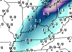
Today’s latest from the GFS products department…

Forecast for 12 hours ending at 7 A.M. Saturday.

Unfortunately for local snow fans, this is probably a little too optimistic for Louisville.

Yesterday there was a very wide range of computer solutions for the storm late this week.  Confidence is higher now as two changes have occurred in the past 24 hours.  First, the various models have converged in their solutions.  Second, the very unusual (and snowy) solution by the operational GFS has faded into a much more realistic-looking forecast today.

In general, my current expectation goes like this:  strengthening low pressure will develop over the northwest Gulf of Mexico and move northeastward tomorrow.  It will accelerate quickly along the spine of the Appalachians tomorrow night.  That storm track will be very important.  A little farther west than expected and we’ll see almost all rain with just a little snow at the end.  If the track moves a little east of current thought, we could be in for a heavy snow (5″-10″).

The highest probability, though, would be for the storm to follow the current projected path OR to the left (west) of the current prediction.  As usual, the NAM is a little more rambunctious with this system.  It almost always is more energetic than the GFS 48 hours in advance, but the GFS is almost always better in the end.

So, here’s what I expect – rain showers become likely by afternoon tomorrow. Rain continues tomorrow night and Friday morning.  Temperatures turn colder by Friday afternoon and the rain changes to snow by mid-to-late afternoon.  Temperatures will drop rapidly as the rain transitions to snow.  A “flash freeze” of roads will be possible.  Snow diminishes after midnight.  Total snow accumulation for the Louisville area:  1″ – 3″  Less snow will fall east of Louisville.  For instance, Lexington should see little more than flurries.

Note:  Very heavy snows are expected west and north of Louisville.  A swath of snow should fall over western TN, western KY, southwest and central IN.  Paducah, Evansville, and Indy could get as much as 6″-12″ Friday afternoon and night.