Wednesday 30, 2015
Usually, I keep my weather thoughts local, but hurricanes seem to catch people’s eyes no matter where they are. So, some things I find interesting about what I’ve seen concerning Hurricane Joaquim today.
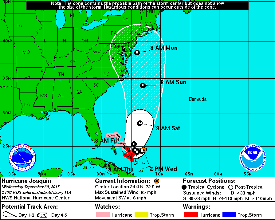
First, the National Hurricane Center’s current forecast path chart (below) hugs the east coast from the Carolinas all the way to eastern Canada. However, no model I’ve looked at shows anything like that. I know the projection is a composite, but it’s not really telling us anything. (Actually, it’s probably intended that way. CYA as the saying goes.)
Also, the chart’s timing doesn’t seem to follow much of the guidance, either.
Now, let’s try to really do some forecasting of Joaquim. First we have two “outlyers” in the models. The European takes the storm far off the east coast with the only problem being a pass near Bermuda, but probably only as a fading tropical storm. The NAM basically keeps it stationary for a couple of days, then rips it apart as it begins to move (upper shear increases). But this still leaves the possible of same very heavy rains along the east coast over the weekend into early next week.
Now, the GFS models, joined by the Canadian and Navy models) point toward a far different solution – one that makes a lot of sense to me. But it does lie outside of the “official” guidance envelope.
Nevertheless, here’s what the models say to me at this time. The weak upper air disturbance which has brought the very much needed rains to us the past two days has basically “cut off” for the main upper level flow and will drift slowly southward for next couple of days – basically a small pool of cold air aloft to keep weather unstable over the areas south and east of the Ohio River. By late week, another pocket of cold air aloft with arrive to strengthen the “cutoff” and push it a little eastward – just far enough to absorb the circulation of Joaquim and drag it westward into the southeast coast. When the cutoff low absorbs we start developing the major transition of Joaquim from a hurricane (or tropical storm) into what’s now called an extratropical low (Years ago the NHC started calling these rare hybred systems “neutercanes” but the name never caught on.)
In laymen’s terms what that means is mid latitude low pressure dynamics coupled with tropical moisture. The usual result is not much of a wind problem, but PLENTY of rain and flooding problems.
Assuming the above process happens, here’s what I expect – Tropical Storm (or small hurricane) Joaquim will hit Saturday night along the Carolina Coast – probably between Myrtle Beach and the Outer Banks. The decaying storm will then drift around the Carolinas for up to 48 hours causing massive rains and major flooding. Heavy rains will also move up the east coast Sunday, Monday and Tuesday.
Update tomorrow!
Note:
So far this year eight people have been killed by sharks. And, 12 people have been killed while taking “selfies.” Message: Beware the selfie!

