Valentine’s Day weather treat

Sunday, Feb. 14, 2016  (Noon)

Everything still looks on track with previous discussions on today’s snow.  After a dusting this this morning, steady snow should be arriving by 1 P.M.  Heaviest snows  should be between 2 P.M. and 5 P.M.  Models today have been a little more generous with snow accumulations, so I’m going to increase my forecast a bit.  I now expect we’ll see a 2″ – 3″ snow accumulation this afternoon and early evening.  Snow should fade to a few flurries by 7 P.M. to 9 P.M. tonight.  Rising temperatures into the 40’s tomorrow should wipe out the snow quickly.

That third “short wave” I’ve been discussing the past few days is still going to be the biggest one.  Look for heavy snows 6″ + along the Appalachians (from eastern KY up into New England tomorrow.  That system could also bring us a little rain (especially east of I-65) late tomorrow.

Another clipper should bring us a little rain and/or snow late Tuesday.  Then, a BIG warming trend later this week!

Today’s snow…

Snow: approx.:  1 P.M. – 8 P.M.

Snow accumulation: Louisville area 2″ -3″.         The southern half of Kentucky will see higher totals.  South of the parkways should get 4″-6″ of snow, especially west of I-65.  Southern Indiana will be on the lighter side – mostly 1″ -2″, but up to 3″ near the river.

Let the fun begin!  Happy Valentine’s day!

Snow still looks likely for Sunday

Saturday, February 14, 2016

Today’s GFS and NAM have become pretty close to each other with regard to the light snow storm expected tomorrow.  And, they both continue the faster approach of the snow.  As it looks now, snow should begin tomorrow morning.  Arrival time should be between 10 A.M. and NOON.  Snow should continue through the afternoon, then diminish during the evening.  Accumulation around the Louisville area should run in the 1″ – 2″ range.  Higher snow totals are likely over most of Kentucky south of Louisville.  Plus, another Gulf coastal storm forming early Monday could add additional snow for the southern half of the commonwealth.  That storm should not effect southern Indiana or northern KY.

So, by midday Monday, accumulations of snow could reach the 4″-8″ range over southern KY while the Louisville area remains in the 1″ – 2″ range (or lower by then).  Temperatures Monday should jump into the 40’s, so any snow we get won’t last long.

Looking ahead…yet another Clipper appears on the horizon for Tuesday.  Current indications are that the surface reflection of the system will move north of Kentucky.  That puts us in the zone where not much happens.  After that temperatures should begin a major upward trend – could even reach the 60’s by next Friday.

Stuff

Monday we’ll celebrate Presidents Day.  However, there really is no “official” day to celebrate our Presidents.  The official name is still Washington’s Birthday.  But, after the 1971 act to make the three-day weekends, people have just been calling it Presidents Day.  But, it’s not!

Weekend weather outlook

Friday, February 12, 2016

Another blast of cold air is pushing across the Ohio Valley setting the stage for a very cold weekend. The new surge of cold air should bring along  some snow flurries, but just a dusting of snow is likely.  High temperatures tomorrow will only reach 20-22 but Sunday should warm to around 30.  But, the big question is whether all that cold air will be setting the table for some snow.

Yesterday, I discussed the upper level “wave train”  that would the big feature in our weather for the next few days.  (Additional details in yesterday’s post)  Wave 1 passed over the area this morning with the expected results.  Wave 2 still looks on target to the discussion yesterday…with one exception.  It now looks as though the timing of the system will be about 6-12 hours earlier thought.

So, Sunday’s outlook now looks like this:  Thickening clouds during the day with light snow beginning by late afternoon.  Periods of light snow continue overnight but ending before daybreak.  This remains a rather disorganized storm system.  Snow forecast remains in the 1″ to 2″ for the Louisville area with perhaps a little more over southern Kentucky.

Biggest changes to forecast are with the “last wave on the train.”  As mentioned yesterday, the last energy pulse is (almost) always the strongest.  Today’s models have emphasized that idea by making wave 3 even deeper that yesterday.  If this trend holds up, what once looked like a good chance for a sizable snowstorm now looks as though it’ll probably miss us entirely.  Now appears that the storm will organize over the Gulf states then head up the Appalachians as another major snow-maker for the eastern states.

As things stand now, the Washington’s Birthday holiday will be cloudy and cold with snow flurries possible – a far cry from what the models have been indicating for the past week.  Oh, well.  There’s still time for change.

Stuff

Valentine’s Day derives from an ancient Roman festival named Lupercalia.  The February 13-15th festival was a fertility rite believed to be in honor of the god of agriculture.

Series of Clippers headed our way

Thursday, Feb. 11, 2016

Clipper #1 – Tonight and tomorrow

This clipper will take a path from Iowa, Missouri into western Tennessee tonight then turn eastward tomorrow.  Very little moisture is available as the atmosphere is very cold.  Any significant snows will stay west and south of the Louisville, but the SW third of KY could pick an inch or two late tonight/tomorrow morning.  Meanwhile, the Louisville area will be on the edge of this system with plenty of clouds, but little, if any, snow accumulation.  Our best chance for snow will be between 7 A..M. – 10 A.M. tomorrow.  Some flurries could linger tomorrow afternoon.

Clipper #2  – Late Sunday into Monday morning

This clipper has more potential than #1.  We’ll see strong southerly winds Sunday in advance of the system.  That’ll warm us a bit (near 32 deg) but more importantly it’ll allow the clipper to tap into some Gulf moisture.  Nevertheless, the upper dynamics don’t look too great.  At this time, the models don’t organize the upper pattern into a single point of energy.  Rather, the energy remains rather diffuse.  Overall, it looks to have the potential for, roughly, a one to two inch snowfall.

Clipper #3 – Monday night and Tuesday morning

There’s an old saying in the forecasting world…”The last wave on the train is the strongest.”  Commonly, we call the little, fast-moving pockets of upper level energy “clippers.”  In meteorological lingo, however, they are known as “short waves” as they are little bits of energy moving along the troughs and ridges of the much larger “long waves” that circle the globe.  A series of short waves moving through a trough is called a “wave train.”

The primary long wave pattern over North America will be shifting next week into a warmer pattern.  But, not before the “last wave on the train” hits us Monday night into Tuesday.  For simplicity, I’ve named it Clipper #3.  And, yes, it’ll be far stronger than numbers 1 and 2!

This system has the potential be become a major winter storm.  But what it will bring us is an open question.  Depending upon the way you interpret the models, we could be looking at a big snowstorm (like the one that didn’t show up a couple of weeks ago).  Or, a major ice storm could be looming.  Another choice could be snow changing to rain and then back to snow on the tail end.  We’ll probably hear a lot of different “forecasts” about this storm over the next few days.  Most of them will be wrong.  It’s just too early to tell.

Revised snow forecast

Monday, 02/8/2016  5 P.M.

Quick update to adjust forecast to current trends…

The upper level low expected to move over the area this evening is right on schedule, however, it’s path now looks like it’ll stay just west of Louisville.  So, heaviest snows – an inch or so – will stay west and south of us (Evansville, Owensboro, Leitchfield, Bowling Green, Hopkinsville, etc.) now look as though they might pick up 1″-2″ overnight.

Elsewhere, the short term models are showing a quick drying of the lower atmosphere in the wake of the short wave.  Radar confirms the decreasing intensity of the snowfall headed our way.  The region of snow showers is headed elsewhere, so we’re down to mostly flurries.  So, I’m getting less optimistic about our snow totals.

Louisville and surrounding areas:  Snow flurries this evening should (mostly) end by 9 P.M.  After that, a few scattered flurries overnight with an uptick in areal coverage beginning around daybreak.  Flurries continue tomorrow.

Snow accumulation tonight – a dusting up to as much as one inch.

Little, or no, additional accumulation tomorrow.

I still expect some slick spots on area roads tonight and for rush hour in the morning.

Snow showers and flurries

Monday, 2/8/2016

Beautiful snow shower passed by my house this morning…left a nice coating of snow, but now it’s just about all gone.  Additional snow showers are likely with much the same result – melting soon after the shower passes.  Some accumulations on grassy areas, but roads remain wet.

It’ll arrive a little earlier than I thought yesterday (see Super Sunday blog), but the small pocket of upper air energy is still on target to bring us more, perhaps heavier,  snow showers this evening.  It looks as though the best chance for snow accumulations will come between about 6 P.M. – 10 P.M. tonight.  After that, it looks like more of a “flurries” regime than a “snow showers” one overnight.  I still expect road problems tonight and tomorrow morning’s rush hour.

Due to the “hit ‘n’ miss” nature of the snow showers, snow accumulations by tomorrow morning could be quite varied.  I expect that most of the area will receive at least one inch of snow, but areas hit by one or two of the heavier snow showers this evening could easily reach 2″ -3″ (or higher) by morning.

It’ll be very cold tomorrow…temperatures should remain in the 20’s all day with gusty winds and flurries to add to the uncomfortable conditions.

Super Bowl prediction:

I was happily surprised with yesterday’s game.  Didn’t believe the Broncos could pull it off.  Their offense wasn’t going to win any championships, but that incredible defense took care of stopping Cam and co. as well as doing much of the job for the offense!

So,  congrats to the Broncs…Kent Taylor must be happiest man in Louisville today!

Super Sunday

Sunday, 2/7/2016

Super Sunday turns out to have a double meaning for us…great weather plus the Super Bowl this evening.

First, the weather.  Enjoy today because winter will be rushing back in by tomorrow.  The commonly called “Polar Vortex”  is once again pushing south into eastern North America.  A sharp cold front will arrive tonight and replace the current seasonably warm  conditions with an Arctic blast.  Since the system’s origins precludes any significant amount of moisture, the cold air will only be accompanied by snow flurries and snow showers.  Timing makes a great difference in events like this. Day vs. night makes a big difference.  I discussed this in a Jan.14, 2016 blog…Observations from this week’s snows.  Check it out.

Here’s how the current situation is shaping up… cold air arrives late tonight along with a 30%  chance for rain showers.  It’ll take several hours, probably between 8-10 A.M., for the air to become cold enough to support snow rather than rain showers.  Periods of light snow likely during the afternoon with up to a half-inch on grassy areas.  Roads remain wet, but possibly a few slick spots on bridges and overpasses toward evening.

Monday night looks like the best  chance for accumulating snow from this system.  Cold air will be firmly entrenched, still some residual moisture will be around and an upper air pocket of energy looks as though it’ll fly overhead.  The result should be some light snow and some snow showers.  Most of us should see .5″ to 1.5″ by Tuesday morning. Some areas will probably see some heavier snow showers putting down as much as 2″-3″, but they should be pretty scattered.

By Tuesday, we’ll still have plenty of cold air (20’s for highs),  but there won’t be much moisture or upper support left.  So, snow flurries will continue, but little (or no) accumulation is expected.

Although this won’t be much of a snowstorm, there’s still the potential for some major road problems from early Tuesday through Tuesday morning.

Super Bowl

I’ve only attended one professional football regular season game in my life.  It was at Mile High Stadium back in the late 1960’s and featured Denver winning over the Buffalo Bills. I think the score was 17-14. I’ve had a warm spot for the Broncos in my hearts ever since.  But, trying to look objectively at today’s game, I think the Denver Super Bowl mystique will continue.  Denver has been in seven Super Bowls but has won only two.  The average winning margin of those games has been over 20 points.  All but one game have been blowouts, The Broncos have been on the losing end of a blowout five times.  Today looks like it’ll be #6.  (Sorry, Broncs and my sympathies go to Kent Taylor…a HUGE Broncos fan!)

Tornado Watch – south of Louisville

Update 2/2/2016

Some minor changes from previous 2/2/2016 blog.

A large, unorganized cluster of showers/thunderstorms has popped up over western KY and is spreading  NE.  Based on a few isolated storm reports, the Storm Prediction Center has issued a Tornado Watch for all of central KY south of the Louisville area. Models are even stronger than before on the rapid decrease in strength as this storm area moves east.  Heaviest storms, possibly severe, will remain over southcentral KY with a better chance in TN.  As mentioned, the storm cluster is moving into an unfavorable stability situation, so heavy remain seems to be the main concern in the Louisville area (35 miles in all directions from city).

Primary threat remains the cold front itself. It is suddenly getting very active near the Mississippi River.  This still looks as though it’ll pass through the Louisville area between 10 P.M. and 2 A.M.  It, too, will have the instability problem but should produce some very heavy rain. (See earlier post)

Windy…yes. Stormy…maybe.

Tuesday, 2/2/2016

First, the Wind Advisory…

...WIND ADVISORY IN EFFECT FROM 1 PM THIS AFTERNOON TO 7 AM EST
WEDNESDAY...

.THIS AFTERNOON...CLOUDY WITH SCATTERED SHOWERS AND
THUNDERSTORMS. HIGHS AROUND 70. SOUTHEAST WINDS 10 TO 20 MPH.
GUSTS TO AROUND 40 MPH IN THE AFTERNOON. CHANCE OF PRECIPITATION
40 PERCENT.
.TONIGHT...BREEZY. SHOWERS AND THUNDERSTORMS. SOME THUNDERSTORMS
MAY PRODUCE DAMAGING WINDS. LOWS AROUND 50. SOUTH WINDS 10 TO
25 MPH WITH GUSTS TO AROUND 40 MPH. CHANCE OF PRECIPITATION NEAR
100 PERCENT.

Now, here is the NWS definition for a Wind Advisory…

Wind Advisory

A Wind Advisory is issued when the following conditions are expected for 3 hours or longer.

1) sustained winds of 31 to 39 mph    

AND/OR

2) wind gusts of 46 to 57 mph.

Notice anything unusual?  Yes, the forecast doesn’t came anywhere close to the definition.  And, this is the third time they’ve done this in the past couple of months!

So, let’s put it this way…it’s going to be noticeably windy this afternoon and tonight.  But, Wind Advisory criteria?  Very doubtful.

Severe weather situation

As a massive winter storm moves slowly NE out of Kansas toward the western Great Lakes, a major outbreak of severe storms is expected along the Mississippi Valley late this afternoon into early evening.  The western third of KY and southwestern IN could be hard-hit.  But for the Louisville area the situation is much different.

As is often the case with winter severe storm outbreaks, the dynamics (wind fields, etc) are very strong.  But the thermodynamics (temperatures, moisture, etc) are weak.  Sometimes, the dynamics can overwhelm the weaker thermo and wreak havoc.  That is expected late this afternoon and early evening along and near the Mississippi River.  Severe storms and some strong, long track tornadoes appear possible.

During that time, the thermodynamics will be at their peak.  But, the models never bring any positive thermos into central KY or southern IN.  Any instability dies quickly to our west after 6 P.M.  As the cold front slowly advances eastward, the expected severe storm areas consolidate into the line of gusty winds and very heavy rainfall as it approaches the I-65 corridor.  Biggest threat for our area should be flash flooding.  It’s possible we could see 2″-3″ of rain in a few hours, so watch out for flooding in low-lying areas.  If flooding is going to occur, it should be Midnight or later

As for the timing of the windy, rainy and possibly stormy weather…  For the Louisville area, the primary squally system should pass the area between 10 P.M. and 2 A.M.

Note:

The definition of the severe thunderstorm is Winds reaching 58 mph or higher and/or one inch hail.  I don’t believe either of those items will occur in the Louisville area tonight.  NEVERTHELESS, I do believe a Severe Thunderstorm Warning will be issued locally.  After all, can anybody remember the last time a moderate to strong line the thunderstorms has passed Louisville WITHOUT a warning being issued?  (It’s kind of like that Windy Advisory thing.)

Stuff:

I was happily impressed with the Cardinals win over UNC last night.  Good testament to the character of the team to bounce back from Saturday’s game with UVA.  It also speaks well for a team, such as UVA, that can completely change a game with their exceptional defense.

January thaw has late arrival.

Thursday 1/28/2016

Weather update:

After a couple weeks of wintry weather, a common January weather feature is entering the game – the January Thaw.  For centuries, weather watchers have noticed a tendency for a period of milder, calmer weather to hit the eastern half of the U.S. during the latter part of January.  This year (it doesn’t happen happen every year) it’s a bit late. We’ve been experiencing a rather weak example of it this week, but it’ll really kick into action by the weekend.  Temperatures could reach 60 or so then, but it’ll be even warmer early next week when even 70 degrees is not out of question. A strong storm will come out of the southwest early next week and move northward through the Mississippi Valley.  That will bring us strong southern winds and warm, rainy weather Tuesday and Tuesday night.  That’ll be it for this year’s “Thaw” as wintry conditions will return by midweek.

The “10 year deadline” has passed.  Why are we still here?

It was 10 years ago this week when former Vice President Al Gore made his (at the time) famous proclamation that if we didn’t make drastic efforts to end global warming in the next 10 years, Earth was doomed.  Well, the years have passed, Earth hasn’t warmed (according to satellite data), we haven’t done much to reduce the supposed enemy – carbon dioxide, and everything seems to be rolling along smoothly.  Of course, Al’s made a fortune acting as the shill for some climate fanatics, so he’ll be well prepared when the end arrives.

If you’d like more detail on Al’s proclamations and predictions, check out this article from the climate website Watt’s Up With That?   http://wattsupwiththat.com/2016/01/25/state-of-the-climate-10-years-after-al-gore-declared-a-planetary-emergency-top-10-reasons-gore-was-wrong/

2015 – Hottest Year Ever?

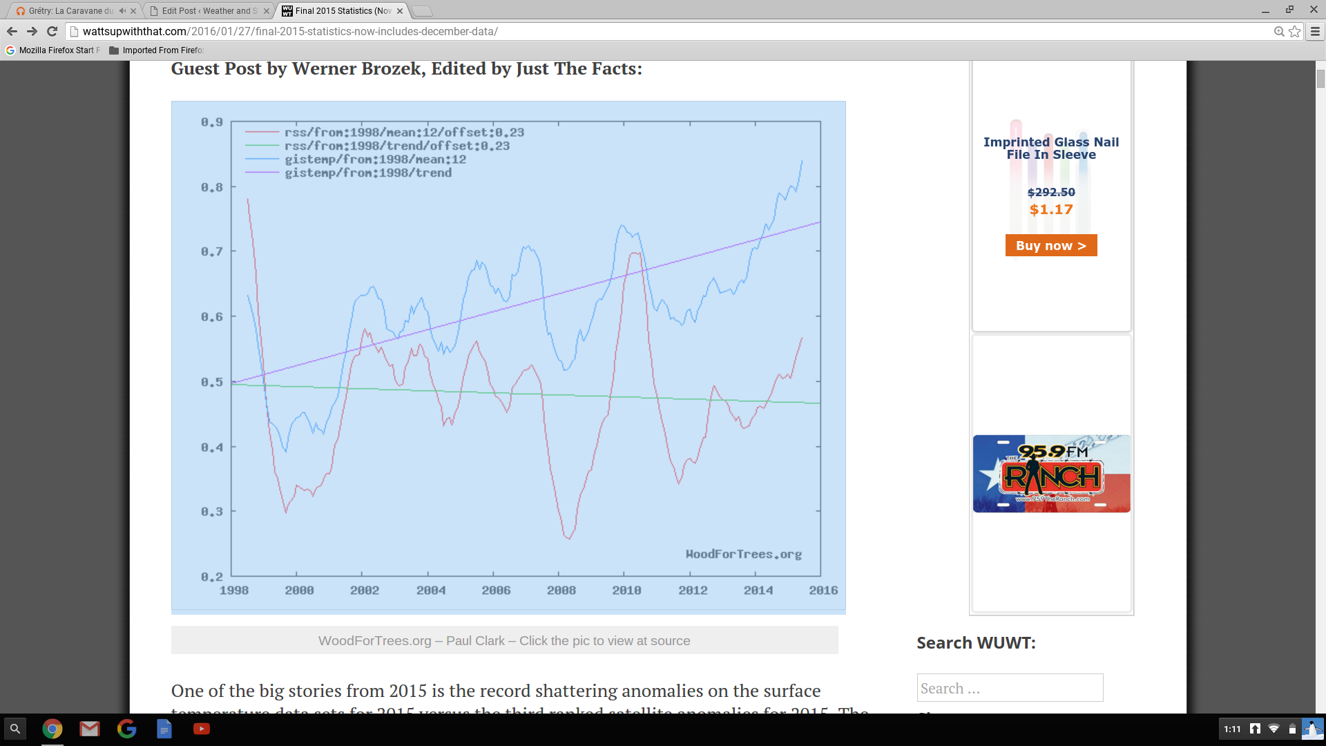
Last week our government announced NOAA ‘s and NASA’s findings that 2015 was the warmest year on record.  This is based on their analysis of global surface data that they have “adjusted” so many times as to be barely recognizable.  But, it fits the agenda.  Interestingly, our government also pays two groups to measure Earth’s temperatures.  Have you ever heard satellite data discussed during their “hottest this, warmest that” press conferences?  No, I didn’t think so.  The two satellite groups are GSS (Global Satellite Services) and UAH (University of Alabama-Huntsville).  The satellite global temperature surveys began in late 1978 and have closely matched each other over the years.  Why haven’t you heard about them?  This graph shows you why… Screenshot 2016-01-28 at 1.11.58 PM    Satellite data doesn’t support the agenda.