Two good shots for snow this week.

Sunday,  Jan. 17, 2016

A few flurries arriving this afternoon along with another shot of Arctic air will set the stage for what could turn out to be a snowy week.  The first good chance will arrive Wednesday while the second seems to be on tap for Friday.  The current GFS model looks pretty impressive, but I’m always forced to use the disclaimer – A lot can change in a few days.  But, it’s always fun to speculate.  So here goes…

A weak to moderate disturbance will drift into the Ohio Valley by Wednesday.  It’ll be overriding the cold air mass arriving today, so surface moisture will be very limited.  Nevertheless, the GFS is trying very hard to generate its own moisture and is showing the potential for 2″-3″ of snow.  The NAM is much weaker with this system, but still shows the potential for an inch (possibly as much as two) of snow.

Friday’s system, at this point, looks to be stronger and have more moisture available.  Thus, the snow-making potential could support 4″ + accumulations.  But, there will be some hurdles to jump over before a deep snow can occur.  What happens Wednesday will go a long way toward determining what’s going to happen Friday.  If Wednesday’s system is as strong as the GFS suggests, it’ll drag in another surge of cold air and help support a larger snow on Friday.  The weaker NAM solution plays toward a rain/snow mix early Friday, then snow later.  Either way, it looks as though Friday’s system will be warmer, so it shouldn’t be as bad on the roads.

Of course, potential doesn’t often equal reality.  But, it looks pretty good at this time.  Check back for updates as the events draw closer.

Observations from this week’s snows

Thursday, Jan.14, 2016

The two snows this week pointed out a couple of interesting items: (1) The time and temperature that snow falls is very important and (2) the difference between “snowfall” and “snow accumulation.”

First, according to airport (SDF) data, the two systems had approximately the same liquid water content, so all things being equal we should have had about the same results.  But, we certainly didn’t.  Sunday’s snow fell during rapidly falling temperatures (from above freezing into the 20’s.  The warmer roads, at first, melted the snow.  As it got colder, the roads froze into icy sheets with a thin layer  of snow on top.  Meanwhile, the snow which fell onto the grassy areas didn’t melt (because of no solar radiation at night) and accumulated up to around an inch locally. If that snow had fallen during the day, the result would have been much like what we saw Tuesday.

Tuesday’s snow arrived around daybreak, so it didn’t have the advantage of night to get a jump on accumulations.  Plus temperatures were above 32 degrees.  That snow continued most of the morning, including a strong snow shower around 11 A.M.  That snow shower, if it had occurred around, say, 6 or 7 A.M., would have created a huge mess on the roads.  But, it happened during the day and the roads just stayed wet.

Now, the snowfall vs. accumulation.  This can be confusing because when we forecast snow, we talk about the expected accumulation – how much will my ruler measure on a flat, NON grassy surface.  However, the National Weather Service reports two measurements- snowfall and snow accumulation.  As we saw this week, the two are NOT the same.

Sunday morning’s snow (at night) was right in line with expectations – the weather service reported .8″ of snowfall and 1″ on the ground.  Accumulations are rounded to the nearest inch, so a measured “on the ground” .5″ to 1.4″ would be reported as 1″, etc.

Tuesday, however, was a much different story.  The “official” snow on the ground at 7 A.M. was 1″.  Then came the snow.  It was daytime and temperatures were above 32.  The snow”fall” total reported by the NWS was 1.8″.  At 1 P.M. the officially reported accumulation on the ground was listed as 0.

Good illustration of the difference between snowfall and snow accumulation – we started with one inch on the ground, then a snowfall of 1.8″.  After it was over, we had less than a half inch of snow on the ground.

NOTE:  Situations like this allow almost everybody to proclaim a “correct” forecast.  Monday night, the NWS and many others forecast an accumulation of 1″-2″.  I wasn’t watching Tuesday evening, but based on past experiences, I’d say that a common comment went something like this…”just like we predicted, we had 1.8″ of snowfall…”  They may proclaim to be “correct”, but they were wrong!  And they are trying to convince you they were right.  So, if you are keeping score – give them two strikes instead of one.

There is a difference between snowfall and snow accumulation. although many times forecasters wish you didn’t know.


NOTE:  I don’t know why, but this post today brought to mind an old story circulating about our old “climate specialist” Al Gore.  As you probably know, back in 2007 or so, Al famously announced to the world that due to global warming,  the Arctic would be ice-free (In summer) and the polar bears would have vanished by 2013 or 2014.  Well, here we are in 2016 and the Arctic still has plenty of ice and polar bears.

The comment:  When Al Gore was born, Earth had 7000 polar bears.  Now there are only 30,000 left.


More Snow?

Monday, Jan. 11, 2013

Another Winter Weather Advisory for the area.  Yesterday turned out different than I expected as temperatures dropped much faster than I was expecting, so there were plenty of road problems in spite of the less than an inch (.8″) that was recorded at the airport.

Tonight’s situation is entirely different…we’ll be on the tail end of what is commonly called an Alberta Clipper that will move through the Great Lakes late tonight and tomorrow.  There’s not usually too much to get excited about south of the clipper’s path, but this time may be a little different – at least the NWS seems to think so.  Me, I’m not so sure, but I do think we’ll get something tomorrow morning.

This evening and early tomorrow morning, we’ll probably see what appears to be lots of snow  on the radar, but don’t be fooled.  High levels will be producing snow, but the lower level air is too dry for it to reach the ground.  The result is called virga (falling precipitation that evaporates before reaching the ground).   It looks good on the radar, but the result is disappointing to snow lovers.

That virga over night will be from a weak upper air disturbance preceding the primary clipper system.  While it shouldn’t produce more than a few flakes of snow, it will serve to increase the low level moisture levels so that the primary system should have more chance to drop some snow.

As mentioned above, the major problems with the clipper will be far to our north, but the cold front trailing the system will come racing across Indiana and Kentucky tomorrow morning.  While the atmosphere is very cold right now, it’s hard to squeeze much moisture into the air.  But, it should be able produce a few hours of snow (probably between 6 and 10 A.M. in the Louisville area (earlier to our west and later to our east).

All the models I’ve seen are generating only small amounts of precipitation (less than .10″ liquid), so that doesn’t hint at much snow.  Also, temperatures are expected to remain in the lower 30’s tonight, so the roads should be able to handle it pretty well.

With the Winter Weather Advisory, the Weather Service (and most of our media sycophants) is predicting 1″-3″ of snow.  The indicators don’t look that strong to me.  It’s possible that a few scattered snow showers could produce a few isolated swaths of 1″-2″ of snow (especially over southern Indiana).  The vast majority of the area should see anywhere from a dusting to up to an inch of snow.

Snow?

  Sat. Jan 8, 2016  9 P.M.

Quick look at the winter weather advisory for the area.  Seems to be a bit overdone.  Temperatures should remain above freezing during the time of expected snowfall.  Being it is night, there is a chance for some very sloppy accumulations on grassy areas after 4-5 A.M. but no problems with the roads.  Any accumulating snows should end by daybreak.  Cold and windy, possible flurries Sunday with falling temperatures into the 20’s.

Any snow accumulation on grassy areas should be less than one inch.  Road problems are not espected.


Joaquim hits the headlines

Wednesday 30, 2015

Usually, I keep my weather thoughts local, but hurricanes seem to catch people’s eyes no matter where they are.  So, some  things I find interesting about what I’ve seen concerning Hurricane Joaquim today.

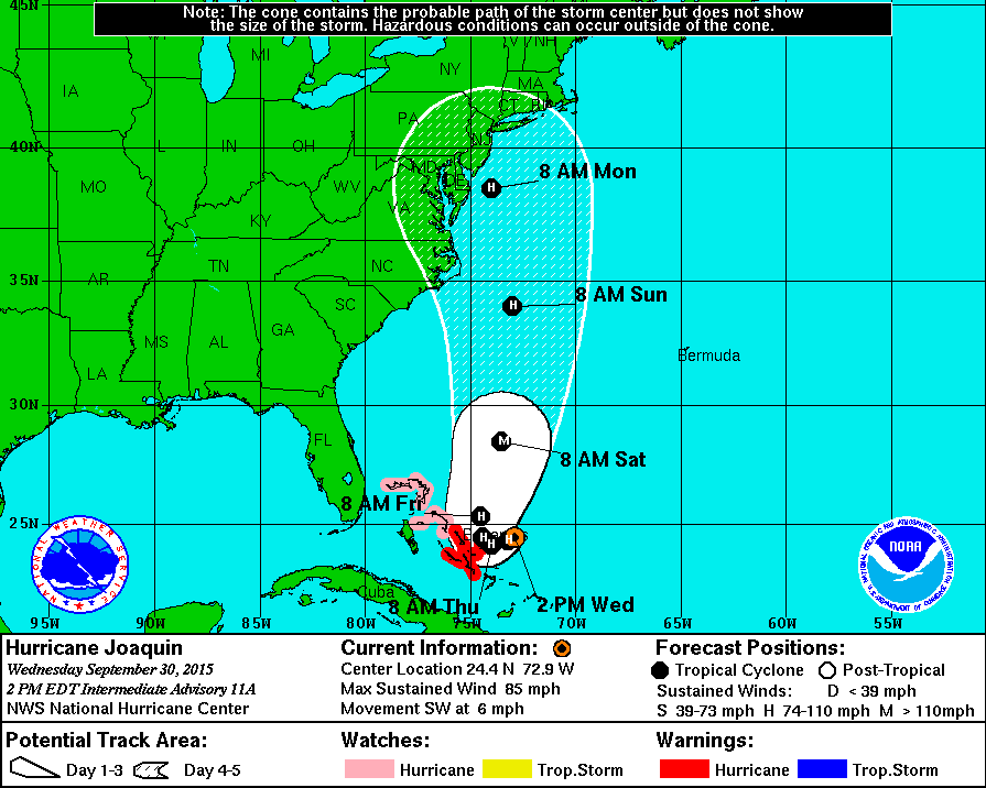
First, the National Hurricane Center’s current forecast path chart (below) hugs the east coast from the Carolinas all the way to eastern Canada.  However, no model I’ve looked at shows anything like that.  I know the projection is a composite, but it’s not really telling us anything.  (Actually, it’s probably intended that way.  CYA as the saying goes.)

Also, the chart’s timing doesn’t seem to follow much of the guidance, either.

joaquim path

Now, let’s try to really do some forecasting of Joaquim.  First we have two “outlyers” in the models.  The European takes the storm far off the east coast with the only problem being a pass near Bermuda, but probably only as a fading tropical storm.  The NAM basically keeps it stationary for a couple of days, then rips it apart as it begins to move (upper shear increases).  But this still leaves the possible of same very heavy rains along the east coast over the weekend into early next week.

Now, the GFS models, joined by the Canadian and Navy models) point toward a far different solution – one that makes a lot of sense to me.  But it does lie outside of the “official” guidance envelope.

Nevertheless, here’s what the models say to me at this time.  The weak upper air disturbance which has brought the very much needed rains to us the past two days has basically “cut off” for the main upper level flow and will drift slowly southward for next couple of days – basically a small pool of cold air aloft to keep weather unstable over the areas south and east of the Ohio River.  By late week, another pocket of cold air aloft with arrive to strengthen the “cutoff” and push it a little eastward – just far enough to absorb the circulation of Joaquim and drag it westward into the southeast coast.  When the cutoff low absorbs we start developing the major transition of Joaquim from a hurricane (or tropical storm) into what’s now called an extratropical low  (Years ago the NHC started calling these rare hybred systems “neutercanes” but the name never caught on.)

In  laymen’s terms what that means is mid latitude low pressure dynamics coupled with tropical moisture.  The usual result is not much of a wind problem, but PLENTY of rain and flooding problems.

Assuming the above process happens, here’s what I expect – Tropical Storm (or small hurricane) Joaquim will hit Saturday night along the Carolina Coast – probably between Myrtle Beach and the Outer Banks.  The decaying storm will then drift around the Carolinas for up to 48 hours causing massive rains and major flooding.  Heavy rains will also move up the east coast Sunday, Monday and Tuesday.

Update tomorrow!

Note:

So far  this year eight people have been killed by sharks.  And, 12 people have been killed while taking “selfies.”    Message:  Beware the selfie!


No big deal, so far

Monday, July 13, 2015 (3 P.M.)

Line of thunderstorms moving through Jefferson County and areas to the east have proven to be nothing more than typical old-fashioned summer afternoon “Toad stranglers”.  Once again, the brief heavy downpours may aggravate recent flash flood problems, but the rainfall has been much less than similar events recently.  Severe weather threat is pretty much over for Louisville area, for now.

On the bigger picture, the expected westward expansion and intensification process of the thunderstorm line over us looks as though it is finally underway.  If it continues, look for severe winds to hit many areas of southcentral and southeastern KY later this afternoon before reaching Tennessee by evening.  Currently, the strongest thunderstorms are concentrated along the I-75 corridor.

Later this afternoon, another cluster of severe thunderstorms is expected to break out over northern IL and IN.  This system should drop southeastward this evening and reach the Ohio River area by midnight or later.  This afternoon’s thunderstorm has taken a large amount of energy out of our atmosphere, so if this system moves as expected, any thunderstorms we get should be less of a threat than the current line – except for the heavy rain/flooding threat.

Storms in area

Monday, July 13, 2:15 P.M.

Just finished a nice post describing current situation, but it was lost in internet-land.  So, a brief capsule.

Storms entering Louisville area have failed to develop as expected (so far).  Quick line of thunderstorms will drop southward through Louisville are between 2:30 and 4:00 P.M.  Heavy rain and strong gusty winds are likely.  A few isolated severe wind gusts are possible, especially east of Louisville (Oldham and Shelby Counties).  Little threat of damaging weather west of I-65.

Useless tornado Watch for Louisville area.

Monday 1:30 P.M. May 11

A Tornado Watch for areas north of the Ohio River (and a small area of Kentucky near Cincinnati) has been recently issued.  But, a quick look at the radar clearly shows any threat to the Louisville has already moved east of the Louisville.

Models are in good agreement that a process known as “bridging” is occurring over the lower Ohio Valley.  That definitely is a downer for severe storms locally AND could very well mean no rain at all from this system.  That’s another big downer since it looks like we won’t get another serious rain chance until early next week.

Meanwhile, back to bridging – sometimes when a storm system moves northwest of us (the big weekend storm-maker is finally leaving the southern plains) it shifts most of the energy northward toward the Great Lakes while leaving a lot of the major moisture over the south. Then, mid-level winds become westerly and drive a wedge of drier air between the northern energy and the southern moisture.  That’s exactly what’s happening today.

Yes, there is a threat from severe (maybe tornadic) storms with the northern system, but not over southern Indiana.  Best chance of severe storms lies north of Indianapolis.  Meanwhile the southern part of the system now is energy-shy but should still produce thunderstorms later today from Tennessee southward.

So, where does that leave us?  Pretty much in no-man’s land.  Bridging is occurring over southern Indiana and most of Kentucky.  There’s still a chance we’ll see showers or a thunderstorm between 5 and 8 P.M., but the probability has dropped to the 20%-30% range.

Oh well, at least it’ll be cooler tomorrow.

Storms approaching Louisville

4:45 P.M. Tuesday (April 7)

Line of strong thunderstorms moving toward Louisville has been the source of numerous Severe Thunderstorm and Tornado Warnings over the past hour or two.  So far, upper circulation has been noted but no reports of any actual tornadoes.

Radar indications are showing the small line shifting southward while the northern edge is becoming more obscured due to heavy rain.  If this trend continues (it should), the greatest threat to the Louisville area will be just south of the city – northern Hardin, Meade and Bullitt Counties should see strong winds and heavy rains.  A small (weak ) tornado is not out of the question.

Meanwhile, the northern half of the line approaching the Louisville area will lose it’s severe weather threat, but still bring heavy downpours and gusty winds.  All activity should pass east and south of Louisville by 6 P.M.

Note:  4:55 P.M. 

Quick radar update shows line acting as described  above.  Primary severe threat will pass south of Louisville.  Northern area seems to be weakening quickly,  Thus, severe threat for Jefferson Co and Clark and Floyd Cos. will be very low.  Meanwhile, northern Hardin and Bullitt Co. will be hardest hit, maybe with severe winds, but tornado chances are very low.

No worries about tornadoes locally

Friday 3 P,M.  (April 3)

I know there’s a Tornado Watch in effect, but realistically it shouldn’t include the Louisville area.  Thunderstorms, not especially strong ones, moving through the area at this time were the reason the Watch included us.  But, they certainly are not strong enough to do any “storm” damage here.  Flooding, however, is a different concern.  Additional heavy rains until about 4-4:30 could easily accentuate our local flooding problems.

The current Tornado Watch has a more realistic chance of producing severe storms over the southern half of Kentucky later this afternoon and evening. At this time, the most likely locations for severe weather appear to along the Tennessee/Kentucky border west of I-65 during the couple of hours.  By early this evening, the primary threat will be over southeastern KY (mostly east of I-75).

The current storms in Louisville area are bringing northerly winds in their wake.  That means cooler and drier air will slide in after 4 P.M.  That means “goodbye” to any severe storm threat for us.  I hope the Storm Prediction Center catches on to this and drops us from the Watch area.  Based on past experience, that won’t happen.  The horse is dead guys, you can stop beating it!

It’s now 3:20 P.M.

Heaviest part of storm cluster has now moved into Oldham, Shelby and Spencer Counties.  And, it looks weaker.  Still some renewed flooding concerns, but probably not much.  Any threat for severe storms is over for anybody within 35 miles or so of Louisville.

Stuff – total lunar eclipse late tonight.

Skies should clear tonight, so early risers tomorrow morning should get a good view of a total eclipse of the moon.  It’ll be “total” for a shorter time than usual (less than five minutes) and harder to see thanks to the morning light, but still it’s a chance to see a relatively rare event.  For full details visit:  www.spaceweather.com