Category Archives: stuff

Cold air highlights the week ahead

Monday, January 21, 2019

After Saturday’s Hall of Shame forecasting by the majority of local prognosticators, the cold air has settled in and calmed our weather for awhile.  Next system in line will be the remains of another large storm that blasted the Pacific northwest over weekend.  This system is diving into the southern  Rockies and then will slide eastward.  Unlike a couple of similar systems (the past two weekends), this one isn’t given much hope of regeneration.  The upper level parent trough is projected to remain, as we meteorologists say, positively tilted.  In this case, very strongly tilted.  That translates into normal people-talk as weak energy levels and very little development.

Tomorrow and Wednesday

The trough, however, will begin brisk southwesterly winds over the midwest and Ohio Valley tomorrow and transport moisture our way quickly.  Increasing clouds tomorrow with much warmer temperatures (into the 40’s).  Rain will return around midnight tomorrow night and continue into midday Wednesday.  Similar to Saturday night, the cold air behind this new system will be late to join the action.  In fact, the true blast of cold air won’t arrive until Thursday.  So there could be some snowflakes Wednesday afternoon, but no accumulation is expected.

Note:  The NWS is forecasting 1″-2″ of rain for us from this system.  That seems pretty high considering the upper support.  Probably closer to one inch than two.                                                                                                                                                                                                                   Later this week

With wintry air again dominating our weather, little active weather is anticipated.  Computer models are hinting at a couple of very weak Alberta Clippers drifting into the area Thu-Sat with periods of cloudiness, but not much chance for any significant snow.

Note:  The GFS is developing a strong Clipper into the western Great Lakes by early next week. Although not posing much of a rain and/or snow threat for us, the clipper is gathering a very potent cold air mass in its wake.  It might be the coldest air mass we’ll see this winter and probably bring along some light snow along with it.  Of course, that’s a week away – a lot of model changes can happen in that time.

Stuff

I see the Courier Journal has gotten even smaller.  The USA Today section has gone off the digital world.  So, there’ll be less paper in the “paper.”  At least the dimensions of the physical paper haven’t shrunk, as they have in recent years.


Another weekend…another storm

Thursday, January 17, 2019…4 P.M.

Subtle changes

If you’re a snow-lover you’re not going to like the small changes to Saturday’s forecast.  Both the GFS and NAM have drifted in the same direction, so I’ve got pretty good confidence the solution they are pointing toward looks realistic.

We’ve been tracking a storm system blasting northern California and a large chunk of Arctic air moving south from Canada.  Original thought was these two systems would merge over the Ohio Valley/midwest on Saturday.  The result of the merged system would bring us plenty of rain (2″-3″) Saturday.  Then, as the cold air rushed in Saturday night, we’d see an inch or two of snow.  I’ve heard talk of heavier snow, a “flash freeze,”  and single-digit temperatures (even sub-zero).

That’s all nonsense if the current model trends are correct.  The new idea is that the west coast trough and the cold air system will not get “in phase” until the primary surface storm system passes east of the Louisville area.  That means the storm system will not get to its rapid development stage until it gets to Ohio or beyond.

Consequences of the recent changes

1).  Rain remains likely most of the day Saturday.  But it won’t be as much.  Totals will probably range in the 1″ to 1.5″ range.

2).  Rain should end by Saturday evening and we’ll probably see some snow flurries and/or snow showers overnight.  Accumulation, if any, should be less than 1″.

3).  The initial surge of colder air will be slower to arrive.  Temperatures will not fall rapidly enough to allow a flash freeze.  Icy spots, however, will form on roadways during Saturday evening.

4).  Sunday will be very cold…probably near 20-22 all day.  Because the primary storm system will intensify north/east of Louisville, the cold air transport southward will be weaker.  Thus, it appears the local temperatures won’t drop into the single digits in the Louisville area either Monday or Tuesday morning.  Rural areas especially in southern IN could see lows below 10 degrees.)

Note:

The cold upper trough expected over the eastern parts of North America due to the Sudden Stratospheric Warning of late December is now in place.  This system should provide us with frequent snow opportunities and plenty of cold air for the next 2-4 weeks.  Forecasting should be lots of fun.

If you’d like a little more detail on what a Sudden Stratospheric Warming is, see my post from a couple of weeks ago.

Stuff:

We are constantly bombarded by the things that the climate change “hawks” want us to hear, so you probably missed the news that the U.S. is one of the world leaders in carbon emissions REDUCTION.  Yes, compared to the 2005 baseline, total U.S. emissions have dropped 11%, even though we had a small increase last year.  As a whole, Europe has dropped a little (1-3%) as well.  But, the rest of the world continues their rapid increases.  Roughly 80-90% of the nations which signed the Paris Climate Accord continue to increase their emissions.  China and India are by far the biggest offenders.

Let’s not blame China too much.  After all, they have a signed agreement with the U.S.  to keep increasing emissions as much as they want until 2030.  The Climate Gang praised that agreement as just about the greatest thing since (the proverbial) sliced bread.  I’ve always felt that the agreement gave China all the bread and the slicer.  Maybe we’ll get some crumbs out of the deal.

Weekend Weather Prospects

6:30 P.M. Thursday, Jan. 10, 2019

Snow and rain likely.

Forecast models have changed little since yesterday, but that’s enough to bring our weekend forecast into better focus.  The primary change is that the NGM and GFS have both warmed a little.  My worry from yesterday about that prospect is looking like a realistic idea.  Consequences follow:

General situation remains the same…a weak system coming out of the southwest will drift ENE across the southern states.  It will start to regenerate Sunday, but that will be too late for us.  With the low center staying to our south, we’ll have a northerly component to our winds, so the colder air will hold in place with only a slight warming modification.

Heavy snow will break out over northern AR and southern Missouri tomorrow and march eastward into KY/IN tomorrow night.  Snow should begin in the I-65 region about midnight or later.  Temperatures should remain at or above 32 degrees overnight, so snow should accumulate ON GRASSY AREAS !”-2″ by morning.  Roads will have only a small accumulation of slushy/wet snow, but,as always, drivers will find the icy spots.  Luckily, since it’ll be Saturday traffic should be light.

Saturday most of the overnight snow will melt away and roads will improve rapidly.  It’s also looking like little or no precipitation will fall during the day.  If anything falls from the sky during the day, it’ll be light rain.

Part 2

Light rain/drizzle moves in Saturday night and continues off and on until early Sunday.  During Sunday, the surface storm system pulls eastward and drags colder air back into the Ohio Valley.  Some light snow/flurries are likely during the day, but little, if any, accumulation is expected.

We need babies!

Read an article today about the slowing birth rate in the U.S.  In general, the thought goes, our female population needs to produce  2.1  children during her lifetime in order to keep our population stable.  Our current rate has dropped to about 1.7.  So, in spite of what we’re being told, we need those immigrants!

Strong storms possible until 7 P.M.

Monday, March 27, 2017  5:30 P.M.

We’re on the northern edge of a Severe Thunderstorm Watch currently.  Primary concern lies south of Louisville over central KY and, especially, central TN.  Activity is due to a small, but intense upper level disturbance racing over the lower Ohio Valley.  Once again, the upper dynamics are strong, but the lower level instability is quite weak.  For the past  few hours, clusters of thunderstorms have been moving NE from southern/southwestern KY.  A few severe storm warnings have been issued, but it appears most of the storms, while strong, have stayed below severe limits (58 mph winds).  Main factor for us has been the weakening of the storms as they encounter the more stable air mass near the Ohio River.

Main line of storms will push through the I-65 corridor (and Louisville area) between 6 and 7 P.M. this evening.  Strong wind gusts and, perhaps, isolated spots of small hail will be likely as the line passes by.  Overall, these storms should have little affect on our  metro area.

BY 7 P.M. any storm threat for the Louisville are will end.  Any additional threat for severe storms will continue east and southeast of us.

Stuff

A little late for the big day itself, but some things to remember about St. Patrick:

1).  He was not Irish.  (He was born in England, sold into slavery in Ireland as a child.  He later escaped and returned to England where he became a priest.  Then he returned to Ireland to help bring Christianity to Ireland.

2).  It is true that there were no snakes in Ireland when Patrick died.  However, there were no snakes in Ireland when he arrived as a priest.  Irish snakes were destroyed about 10,000 years BEFORE Patrick’s era by the most recent Ice Age.


Snow possible Saturday night!

Tuesday, March 7, 2017  7 P.M.

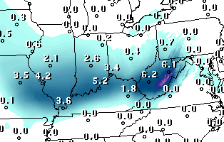
Today’s GFS is predicting a nice snowfall Saturday night (see below).  Of course, a lot can, and will, happen between now and then.  But it is exciting to at least have the thought that we still could have a good snow before the season ends.  Unfortunately, the GFS stands alone at this time…the European model keeps the chance for significant snow north of us.

Meanwhile, here’s the GFS’s snow forecast for the 24-hour forecast ending at 7 A.M. Sunday:

Think snow!

Stuff
Streetside parking meters are illegal in the state of North Dakota.

Charity begins in the home…in this case.  An 87 year old preacher and his wife run an on-line ministry as a “non-profit” organization.  Last year they reported a net income for the website of 7 million dollars.  Their combined salaries added up to $4 million.  That reminds me of the old joke about what to do with the offering plate each Sunday.  “i take the plate, throw it up in the air.  God takes his share and whatever falls back down is mine.”  Only is this case, it’s not a joke!


Atmosphere is set for some big fireworks

Tuesday, Feb. 28, 2017  3:30 P.M.

Both surface and upper air components of the atmosphere are converging on a major “sweet spot” where (and when) ample supplies of severe storm ingredients will come together soon.  A major outbreak of severe weather is expected with large hail, strong winds and tornadoes all looking likely.

WHERE:  Texas, eastern Oklahoma, most of Arkansas, eastern Missouri, Illinois and western Indiana.  Perhaps far western KY as well.

WHEN:  The arrival of the strong storm ingredients should occur over the southern parts of the states listed above around 6 P.M. EST.  The most severe activity will continue for about 8-12 hours.  The prime conditions will uncouple after that and activity will diminish tomorrow morning.  Additional strong storms (but not as strong as tonight’s storms) may reform tomorrow afternoon over eastern KY.

A storm system developing over central Missouri now will rapidly intensify under a very strong upper air flow over the Mississippi Valley and reach the Great Lakes by morning.  Trailing the low pressure will be an eastward moving cold front.  As the front moves into the warm, moist air thunderstorms will break out this evening and accelerate northeastward.  The strong wind fields aloft will have no problems converting the thunderstorms into severe weather-makers quickly.  During the evening, the biggest problems will be over ne TX, east OK and AR.  By Midnight, the greatest threat pushes northward into eastern MO, IL and western IN.  From Midnight until about 6 A.M., the models put a  “bulls eye” over southern IL and southern IN for the greatest damage risk.  NOTE: although the models zero in on the area north of the Ohio River, a few isolated severe storms could develop over western KY counties bordering the Ohio River.

By 6 A.M. the severe storms should be over, or at least diminishing.  By that time the remaining lines/clusters of thunderstorms will be approaching the Louisville area.  The primary area of rain/storms should push through the I-65 corridor between 8 A.M. and Noon.  Some strong winds may still be possible, but the primary threat for our area will be flash flooding.  After the periods of heavy rain today, the ground is saturated.  Additional heavy downpours tomorrow morning would be enough to trigger brief flash flooding.

The cold front is expected to pass though the Louisville area about Noon tomorrow so any additional severe weather generation tomorrow afternoon will be over eastern KY.  Meanwhile, we’ll start a drying process during the afternoon as cooler air arrives.

Stuff

Sunday night’s big Oscar blunder wasn’t the first time that has happened.  But, the first time it happened, the category wasn’t a major one.  In 1964, the “Best Music Score”  award was announced for the movie “Tom Jones.”  But that movie wasn’t even nominated!  The actual winner was Andre Previn for “Irma La Douce.”

Another severe weather attempt

Monday, Feb. 27, 2017

Another strong storm will come out of the southern Rockies and push toward the Great Lakes by Wednesday.  This is a classic severe storm set-up, but the likely timing of the system currently puts us into the very low side of severe storm possibilities.  The highest risk areas will be west of us tomorrow afternoon/evening and east of us for Wednesday afternoon.

The past two similar systems were moisture-shy.  In both cases, nothing of consequence happened locally – thanks to that lack of moisture.  This time, however, there will be plenty of moisture in the equation.  So severe storm outbreaks appear likely tomorrow and Wednesday, but, as mentioned above, the main part of the storm system will reach us during the lull between the two outbreaks.

Here’s how it’s shaping up…a warm front will push through the lower Ohio Valley tonight and tomorrow morning.  This will bring high moisture content into the area.  The front should generate a few hours of showers (and possible thunderstorms) tomorrow morning between about 7 A.M. through Noon.  Any thunderstorms that form tomorrow morning could produce small hail. Then, we’ll see a windy and warm afternoon with temperatures nearing 70 degrees.

During tomorrow afternoon/evening thunderstorms will develop along a cold front from Arkansas to Missouri into Illinois.  A widespread outbreak of severe weather is expected.  As the night continues this cluster of severe weather will drift eastward and weaken.  It is expected to drift through the I-65 corridor Wednesday morning remaining in the weakened state.  Then, Wednesday afternoon it is expected to re-intensify into another area of strong to severe storms as it moves east of the I-75 corridor.

Even though the severe threat looks quite low for the Louisville area, the two (or more) rain systems we expect could easily drop !” to 1.5″ of rain by midday Wednesday.

Stuff

Each panel of glass on the Grand Canyon Skywalk can safely hold 800 people even though the glass is only 2.5″ thick.

Interrupted sleep?

Monday. Feb. 6, 2017

Yes, it appears that thunder and lightning will be visiting our area during the late night hours tonight.  Also, the Severe Storms Center has us in a “slight” risk area for severe thunderstorms tomorrow.  However no severe storms are expected with tonight’s rain/thunder/lightning.

The situation looks like this:  a weak upper air disturbance will float slowly over the Ohio Valley between (roughly) Midnight and Noon tomorrow.  This system is starting to pick up some  Gulf moisture and rain/thunderstorms are popping up over northern TX, AR, west TN and southern KY.  Rain should become widespread over our area after Midnight and finally end around midday.  Thunderstorms will be embedded in the rain shield with the best chance for thunder here about 5 A.M. to 10 A.M.  Overnight instability will be low and the upper air dynamics, while good for an April/May severe weather situation, are actually pretty low for a winter system.  As a result, I don’t expect any severe storms overnight or tomorrow morning.  The dynamics aloft will have a hard time overcoming the lower level thermodynamics.

Then, atmospheric conditions change tomorrow afternoon/evening.  The morning system will drag most of the deep layer of moisture northeast of us.  But, a cold front will be approaching from the northwest.  The dynamics with this coupled surface/upper air system are expected to be much stronger than the overnight system.  However, most of the moisture will have disappeared.  So, the chances for thunderstorms to form along this front are quite small – about 10-20%.  But, if thunderstorms do manage to form, strong gusty winds and hail will be likely.  So, severe storms are possible late tomorrow afternoon , but the chances we’ll have any in the area are less than 10%.  Not much to worry about.  (But a few flurries will be possible early Wednesday.)

February

A couple of weeks ago, a major change in the upper air pattern looked like a good possibility for North America for this month.  The models were leaning toward temperatures being below normal for much of this month.  That trend lasted several days, but since then has shifted back to the primary pattern it has shown much of the winter – cold and wet over the western states and warm and wet over the east.  It looks well locked in, so not much hope for snow lovers.  Bad winter in that regard.

Super Bowl

It was amazing to watch New England turn the tide and rally last night.  You’ve got to give Tom Brady and the Pats credit for putting themselves to win the game, but to my mind, they NEVER should have won the game.  Atlanta just outright “gave” the game away.  With time running out, Atlanta had a second down with the ball in easy field goal range AND an 8 point lead.  Keep the ball where it was.   Run down the clock with a couple of runs – kick the field goal – game over – Super Bowl winners!  But, wait!  Somebody (I assume it was the offensive coordinator) calls a pass play that requires a deep dropback  by the quarterback.  Play starts, qb drops back and gets sacked.  13 yards lost – no longer in field goal range – Patriots get the ball back with a chance to tie the game.  And, they did –  then made it look easy in overtime.

Whoever called that play must have thought he’d catch New England off guard.  Seattle thought the same thing two years ago.  Look where it got them.

Stuff

The popcorn you buy at a movie theater costs more per pound than a filet mignon.

Still hope for some “winter” weather

Sunday, January 22, 2017

It’s been well advertised for the past  ten days or so – an upper level pattern change that was due to begin late this week.  That would shift the major storm activity from the Pacific coast into the eastern U.S., setting up the winter-weather favoring “East Coast trough – West Coast ridge” pattern that would open eastern North America to renewed outbreaks of arctic air.  We haven’t seen this pattern much this winter.  It set up for about 2-3 weeks during December and then again briefly in early January.  Each time, it could not establish a foothold and returned blasting the western U.S. with heavy rain and snow.  That has been good for California, as the years-long drought has been wiped out (for now).

As usually happens when forecasters try to look out a week or two in advance,  the expectations don’t meet the reality when it finally arrives.  That seems to be happening this time as well.  Colder weather appears likely by late week and the weekend.  But, current forecasts for temperatures are running 5-10 degrees warmer than they were a few days ago.  So, it looks as though the first attempt to establish the east coast trough will only drop us into the “near normal” range rather than the previous “below normal” expectations.

But, snow lovers,  there is some good news.  The GFS and the European model continue to deepen (strengthen) the troughing over the eastern U.S. so that Super Bowl weekend should see the beginning of some strong cold air outbreaks ( and maybe some snow(s)).

Although I have repeatedly stated that long range forecasts can be highly unreliable, I will take a stab at what happens after that.  The U.S. has a forecast model known as the Climate Forecast System (CFS) designed to project the months ahead in general terms.  Since I usually concern myself with current weather and a few days ahead,  I’ve never paid much attention to the CFS.   But, if you want to dream big, the CFS is predicting that once the east coast trough really establishes itself (11-14 days from now), it will hold until the end of February!  That could make for a lot of fun next month

(And that could be our last chance as the CFS expects March to return to above normal temperatures.)

Current weather

I seems pretty obvious by now that those forecasts for heavy rains (Thunderstorms?) and possible flooding (especially south of Louisville) are not going to materialize tonight and tomorrow. We’ll probably see some rain tonight, mostly after midnight.  Total should be a quarter-inch or less.  After that, the next few days should be dry with continued mild temperatures.

Stuff

If you were asked,” How many Presidents has Kentucky produced?”, the obvious answer would be “one.”  But, some people count Jefferson Davis as a second President.  That’s a “trick answer” as he was President of the CSA not the USA.  But, in a little-known historical quirk, Abraham Lincoln was actually the second Kentuckian to serve as President of the USA.  Here’s the story from the very interesting website, www.mentalfloss.com. …

In 1849, Zachary Taylor refused to be sworn in on a Sunday, because he was very strict about “keeping holy the Sabbath.” The position of president couldn’t just be vacant until Monday, so the President Pro Tempore of the Senate, David Rice Atchison, was brought in as a pinch hitter. There’s some debate as to whether this actually makes him the 12th president and Zachary Taylor the 13th, but obviously, it’s generally accepted that he doesn’t count. He didn’t even stake claim to the title, and repeatedly told people that he slept through most of his day as president. He must have had a good sense of humor about the whole thing, though, as evidenced by the inscription on his gravestone.


Another attempt at a pattern change.

Monday, November 20, 2016

Two weeks ago I wrote about the upper atmosphere’s attempting to evolve into a different, colder, weather pattern.  It tried, as several weak systems attempted to bring in colder air.  However, the upper air winds were unable to generate the anticipated west coast ridge- east coast trough.  As tv’s Colbert would say, we got some east coast “troughiness”, but not the real thing.

So, two weeks later we find a pattern that still contains a strong upper trough from the Gulf of Alaska southward.  New to the scene has been the development of weak troughing over the northeastern U.S.  The upper ridge over the southeast U.S. has moved westward and weakened quite a bit.  It’s now centered as a very flat ridge over the western Gulf and Texas.

So, what was expected has happened, but to a much smaller degree than anticipated.  Now the atmospheric jet stream over North America has been left in an unusual pattern – too little spacing between the two troughs.  That sets up an unstable situation  which will result in much more weather activity over the next two weeks.  We’ll see a big increase in storms and weather changes as energy pockets swing around the big west coast trough, rapidly swing across the U.S. and hook up with the weak east coast trough.

This situation looks to have two possible solutions – 1).  The increased atmospheric instability shifts enough energy from the western trough to the eastern trough to allow it to become the dominant system. That results in a colder than normal eastern U.S. for December (and probably most of the winter.  Or, 2).  The western trough remains dominant and the eastern one never really establishes much strength.  That would mean a wet, mild December.

So, which scenario is more likely?  Today, both the GFS and European models are favoring scenario number 1.  If it works out this way, we could have a very interesting December, weather-wise!

Stuff

Grey Poupon wasn’t given its name because of the color of the mustard. The moniker actually comes from the names of two 18th century mustard firms from Dijon, run by Maurice Grey and Antoine Poupon.