Thursday afternoon
The upper level waves of energy are slowly working into position to finally visit the lower Ohio Valley. Today’s system is slowly spinning southward along the east side of the Mississippi from Illinois to western KY. I expect it to drift southward and fade away this evening and tonight, so it poses very little threat to our area. However, I’m still concerned about of couple of upper air remnants from today’s system. The GFS continues to bring the energy across KY in two pieces – the first one being the system tonight which I expect to have minimal impact here. The trailing energy pocket should take direct aim on us, with a high chance for showers/thunderstorms tomorrow from about 10 A.M. until 4 P.M. or so. Yesterday, the NAM wasn’t buying that scenario but has moved closer to the GFS reasoning today.
Another problem has popped up for the weather Saturday. The GFS has picked up on another weak pocket of energy coming over the Rockies. While the general trend is to weaken this system, it is projected to move over(or near) us Saturday. Thus, my previously dry Saturday forecast doesn’t look like it’ll hold up. Tomorrow’s system will take some of the upper air moisture along as it heads east. Less moisture and a weakening energy pocket should still be able to at least generate some scattered thunderstorms. But, let me emphasize the scattered, hit ‘n’ miss nature expected Saturday as compared to a longer, more widespread outbreak expected Friday.
With thunderstorm outbreaks you can never be certain what’s going to happen, but that’s how it looks for me now.
Rosetta arrives!
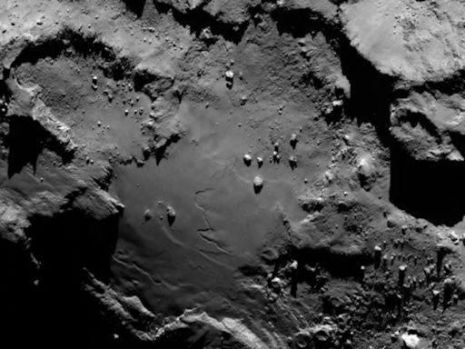
A few days ago, we mentioned the European Space Agency’s (ESA) space probe Rosetta approaching comet 67P. After a ten year journey it arrived about 130 km away from the comet core and will now spend the next month or so jockeying into an orbit about 30 km (20 miles) from the surface. Here’s how the comet looked at a distance of 130 km from Rosetta…photo courtesy of ESA.