Wednesday afternoon
A cold front is approaching and this one appears to be in considerably better shape than the last one. This time, the upper and lower levels are cooperating a little better and their looks like more moisture is available. The only negative I see is the timing. Nighttime, especially late night, is not a good time for thunderstorms this time of year. And, since we didn’t get nearly as much heating as expected today thanks to the clouds, any thunderstorms we get tonight should not pose much of a threat.
One thing that has changed, however, is the timing. Recent trends now point to the best time for the showers/thunderstorms to arrive in our area to be between 10 P.M. and 4 A.M. After that any lingering showers should fade/move away by 8-9 A.M. Cooler air will slowly filter in tomorrow and with mostly cloudy skies we’ll probably stay in the upper 70’s.
Temperatures will stay just a little below normal through Friday, but another cold front will reinforce the cold air with a chilly day Saturday, then a quick bounce back starting Sunday.
Rainfall tonight. Models and forecasters are still sticking with a pretty heavy rainfall tonight. And those areas that receive a strong thunderstorm tonight could see an inch or more of rain in a few hours. However, it is unlikely that many of us are going to see a strong storm tonight as darkness tonight should send this system into a quick decline. A quarter-inch to a half-inch should be the general rain total with some isolated spots reaching an inch or more.
Stuff
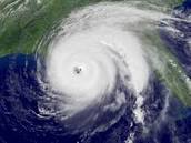
On September 1 this year, NO tropical storms were active anywhere on Earth. This is the first time that has happened in 70 years. (September is, on average, the most active month for tropical storms.) Just in case you miss the usual Sept. portraits…
