
Thursday, March 9, 2017 1:30 P.M.
Today’s forecast models continue the downward trend in the snow forecast they were making earlier this week. I’ve always cautioned against believing snow forecasts made days in advance. Too many subtle differences in nature can add up quickly to major changes. Once again, that seems to be the case. Here’s the GFS snow forecast from last night’s run:
You can see the change over the past few days by checking my last two posts.
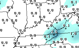
Now that the predicted “event” is closer we can get a much better feel for what’s going to happen. The GFS has continued to push Saturday’s system farther south, keeping rain/snow confined to areas from southern KY and south. The NAM also pushes the main system to our south. However, it still allows the northern edge of the snow to extend into northern KY and far southern IN. This morning’s NAM predicts up to an inch for our area. The GFS keeps us dry. On a probability of measurable precipitation basis the GFS gives us a 35% chance while the more encouraging NAM puts it at 70%.
Personally, the GFS seems more reasonable and I’d lean toward the no snow side of the forecast. However, the GFS’s “verification scores” have been very poor for the past 3-5 days, so there is still reason for hope.