Calmer weather for a couple of days

4 P.M. Feb. 20, 2019

Ohio River on the rise again.

Current hydrological forecasts have the Ohio in Louisville rising to just a inch or so from flood stage by Monday morning.  In the short term, I think that forecast will be revised downward since rainfall last night and today has fallen, in general, a half-inch to one inch shy of forecasts.  Plus, the highest amounts (southwestern Indiana) fell in areas that will drain into the Ohio downriver from Louisville.

Mostly light rain will move east of I-65 by 6-7 P.M. this evening.  Then two dry days lie ahead.  We’ll keep plenty of clouds around, but temperatures will reach about 50 tomorrow and a few degrees warmer on Friday.

Looking ahead

The next big storm to reach us will arrive Saturday and persist about 24 hours.  This one also projects as a big rain-maker.  Current estimates are in the 1″ to 2″ range, down a bit from earlier forecasts.  This storm will determine the fate of the Ohio River here in Louisville.  Another rain in the forecast range could easily put the river out of its banks by early next week.

Looking farther ahead

A lot has been said about an abrupt change back to a much colder pattern around March 1.  Call it “Polar Vortex, Chapter 2”!  Well, the GFS has been predicting some snow on arrival (now looks like Feb.28th) and a substantial snow about March 4 or 5.

Unfortunately, that all changed with this morning’s GFS.  It is now pushing much less cold air southward, as happened last time.  We could still have some light snow upon the cold air’s arrival, but it won’t hang around long enough to prevent the March storm from being rain.

DON’T give up hope!  The GFS has been acting very shaky (wild forecasts) since yesterday’s 18Z (1.P.M.) run, so it could all shift again.

Stuff

Of the world’s “big cats” (lions, tigers, leopards and cheetahs), only the cheetah cannot roar. They , however, can purr.  They also can accelerate to 70 mph in three seconds!


Wet night ahead

4 P.M. Tue., Feb. 19, 2019

Models continue warming trend

Latest NAM, HRRR and RAP models all show a warming and later arriving rain system tonight.  Onset now looks to be 10 P.M. or later tonight.  Wouldn’t be surprised if precipitation begins as a brief period of snow and/or sleet but quickly changes to rain.  No snow accumulation and no icy road road problems.

Rain will be heavy at times tonight and again late tomorrow.  Models still pointing to around 1.5″ to 2″ by tomorrow evening.

Indiana snow forecast has changed.  Southern one-third of IN will see anywhere between a trace (near the Ohio River) up to an inch or two near Columbus before the change to rain.  The northern two-thirds of the state could see 4″+ totals, especially east of I-65.

Models continue the warming trend

Noon Tue., Feb. 19, 2019

Heavy snows for much of Indiana, not for us

The GFS and NAM have pretty much given up on snow for Kentucky.  Louisville area may get a brief dusting, but no problems.  Southern Indiana counties that touch the Ohio River get less than an inch between 9 P.M. and Midnight.  Farther north accumulations will build – Scottsburg should see 1″-3″ while from Seymour north 4″+ of snow is likely.

If Jefferson County gets any snow (9 -11 P.M. will be our chance), it’ll not be enough to cause any road problems. But, heavy rains could create some problems for the morning commute. Rain will lighten during the day, but another surge of heavy rain could make a mess of the evening rush as well.

The GFS and NAM both project 1″-2″ of rain over the next 36 hours.  The NWS projects 2″-3″.  If the total goes that high, renewed flooding is possible on smaller rivers and streams.  Either amount of rain would not be enough to create any problems on the Ohio

Snow chances fade

11 p.m. Monday, Feb. 18, 2019

Evening update

Evening model runs are, in general, running slower with precipitation onset tomorrow evening.  As a result, that gives more time for the atmosphere to warm.  Thus, the chance for snow has  changed to a very small window.

The result, and updated forecast, is now for rain to begin around 9-10 p.m. tomorrow night and produce 1″-2″ of rain by Wed. afternoon.  Rain may begin as a brief period of snow.  Little, if any, accumulation  is expected.

More heavy rain ahead, but first…

4:30 P.M. Monday, Feb. 18, 2019

Most likely rain will start as snow

A quick look at the primary weather charts today would give you the idea that there’s no chance for snow tomorrow night.  But, today’s forecast models allow you to dive much deeper – and they say we’ll see a few hours of snow/sleet before we warm enough for rain.

The  mid and upper atmosphere will warm rapidly tomorrow, but there be some air in the lower 5000 feet of the atmosphere that remains cool enough to create snow before rain takes over.  Even though surface temperatures should reach 40 or higher, the near surface air will remain very dry.  So, as precipitation begins aloft, it will be evaporated before it reaches the surface. Evaporation of water cools the air.  In this case, just enough cooling to allow the snow from aloft to NOT melt before reaching the surface.   Temperatures will probably only drop into the mid 30’s, so it’ll be a very “wet” snow.  Nevertheless, much of the area along and north of I-64 could easily see a 1″-2″ accumulation on grassy areas before the changeover to rain.  Areas south of I-64 will see a rapid drop in snow  – probably 30-40 miles south – should expect no accumulation.

Roadways may see a brief slushy period, but little (if any) accumulation.  Rain will wash away icy spots on the roads by shortly after Midnight, so no trouble with the morning rush – expect for water.  Rain tomorrow night until midday Wednesday should be add up to about 1″-1.5″.  While that’s a good sized rain, it will not be enough to bring back flooding.  After that the next heavy rain is not expected until Saturday.

Stuff

36 degrees    If something is falling out of the sky and it’s 36, there’s 50% chance it’ll be rain and 50% chance it’ll be snow (or some other frozen type).  Above 36, the odds increasingly move toward liquid.  Below 36, the odd increasingly favor frozen types of precipitation.

Update on “No snow tonight”

4 P.M. Fri., Feb 15, 2019

Slight model changes

Most recent runs of HRRR and RAP are shifting the expected precipitation northward.  1″ – 2″ of snow still remain likely over the lower two-thirds of KY.  The Louisville area still looks like a strong “no accumulation” but some spots south of I-64 could get a dusting this evening.  Chances for measurable snowfall still fall in the 10% – 20% range.

Presidents Day

The Federal holiday commonly called Presidents Day will be Monday – the third Monday in February.  But something is wrong with the that statement!  Here’s the story…Congress approved a holiday named Washington’s Birthday in 1879.  By 1885 the February 22nd holiday became widespread across the country.  Later Lincoln’s birthday also became a federal holiday.  When Congress passed the Uniform Holidays Act of 1968, the date was changed to the third Monday of February BUT the name was never changed.  So, Monday’s holiday we’ll celebrate will be Washington’s Birthday, not what most people call it.

No snow tonight

11:30 A.M. Fri, Feb. 15, 2019

Snow belt stays west and south of Louisville

No model run this morning shows any snowfall for southern Indiana or the Louisville area tonight.  1″-2″ snows are still possible along the KY/TN border area.  But the Louisville area will remain cold and dry.  NWS still persists with it’s 90% chance for snow tonight, but it’s just not going to happen.  Proper snow chance should be in the 10% to 25% range.

Next precipitation for Louisville area should come Sunday with some light rain likely.

Sorry, snow lovers, that’s just the way it is this time.

Forecast models still at odds

Thursday, Feb. 14, 2019  4:30 P.M.

Snow possible tomorrow night!

Happy Valentines Day!

First of all – tonight.  A weak cold front will cross the area.  It has little upper air support and slim moisture available.  Nevertheless, it could squeeze out a few, brief light showers tonight.  Only about a 30% chance for a measurable amount.  Temperatures tomorrow should stay near 40 during the day.

Snow situation

The northwest U.S. is being pounded by yet another winter storm.  A small piece of upper air energy is breaking away from the parent system and will move eastward across the country over the next two days.  Both the GFS and NAM portray this system a little stronger than yesterday.  They still differ on the storm path and consequences for us.

The GFS is gung ho on snow for us as the surface system slides south of us tomorrow night.  GFS snow totals are around 2″ for Louisville area with heavier totals (up to 4″) over  SW Indiana and western Kentucky.  Snow forecast is even higher along a path from near Evansville to south of St. Louis to Kansas City.

Then, there is the NAM.  Like yesterday, it isn’t taking the snow very seriously for the Louisville area.  It projects the storm track to be a little farther south.  That puts us on the northern edge of the snow threat.  Southern KY will see a mix of snow, sleet, freezing rain and rain creating major road problems tomorrow night and early Saturday.  It also has the heavy snow from far western KY back into Missouri.

So, which model is correct?

Good question.  Can you wait until Sunday morning for the answer?  Of course not!  We want to know beforehand.  So, I’ll give you my thoughts on the situation.

In general, most of the forecasting fraternity will go with the GFS.  Over the long haul, it seems to be the better of the two.  But, this winter the GFS has had snow lovers salivating over two big snow forecasts.  Both times local media and National Weather Service followed the GFS and went into hype mode only to have both forecasts fail.  Overall, the GFS has been in a slump but the NWS is going along with its 2″ forecast for tomorrow night.

But, what about the NAM?  It’s a good model, too.  But the wide differences between the two models for this forecast must mean something.  If tomorrow night’s weather solution were “settled science”, the two models would be very close.  The fact that they are not close tells us there is something about this atmospheric setup that they can’t quite resolve.  In essence, neither model can be ignored.

So, here’s my best shot.  I’m leaning toward the NAM ideas having the surface storm taking a more southerly track.  That means less snow for the Louisville area.  I’m expecting less than one inch for Louisville metro.  Snow totals will increase south of the city and could get an inch or two down to the E’town area.  South of the parkway they’ll see the wintry mix described above.

West of Louisville snow accumulate along and south of I-64.  The farther west in IN/KY, the more snow – as high as 4″ near Evansville.  North of Louisville, little or no snow will fall.

Again,  I believe the Louisville area will be on the northern edge of the snow system.  I expect less than 1″…probably closer to the lower end of the range.

Valentines Day

For hundreds of years BCE (B.C.), the Romans celebrated a Spring ritual known as Lupercalia.  It was a fertility rite to welcome back the growing season, among other things.  It was celebrated around February 14th.  About 500 CE (A.D.) the Catholic Church  decided that Lupercalia was a little too bawdy  for its flock, so it was banned.  It was replaced by a new Church holiday they named Valentines Day in honor of an Italian saint who had been decapitated (by the Romans).

Weather’s dry, but flooding continues

Wed., Feb. 13, 2019  5 P.M.

Two chances for wintry weather later this week

Big winds last night, but they couldn’t push in much cold air.  Wind direction stayed from the SW to W last night and today, so not much cold air pushed southward.  And as winds go back to SW  tomorrow, a very quick warm up is due.  Temperatures are expected to reach about 60 tomorrow.

Then, a weak cold front will pass by tomorrow night with a small (20%) chance for some rain showers after midnight.  Then some colder air arrives for Friday.  And with the colder air, the chance for some light snow returns as well.

Weekend snow?

Two weak upper air disturbances will arrive from the west coast.  The first one arrives Friday night and (at this time) appears as though the southern half of KY could see an inch or two of snow by Saturday morning.  We’ll be on the northern edge of this system and any snow we get would be less than an inch.  NOTE:  At this time, this system is very “iffy”.  The description above is portrayed only by the GFS.  The NAM pretty much ignores this system.  So, I suspect we’ll be hearing changing forecasts in the next few days.

The second system is expected to be a little stronger.  It arrives Saturday night and continues into Sunday.  Temperatures are likely to remain above 32 during this event.  The majority of the precipitation will be rain and/or drizzle.  However, it may start briefly as some light snow.  The GFS and NAM are in pretty close agreement with this system.

Ohio River

The Ohio’s still above flood stage and climbing slowly.  Crest is still expected Friday at around 28′ to 28.5′.  However, the river will fall slowly and will not drop below flood stage until next week.

Strange weather in Hawaii

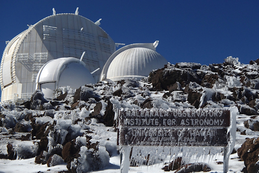
A major storm rocked Hawaii Sunday and Monday.  Some coastal waves were estimated to be as high as 60 feet!  A wind gust of 191 miles per hour was recorded.

The Haleakala Observatory, which sits atop the 10,023 foot Haleakala Volcano on Maui, contains several of the worlds finest telescopes.  They were frozen in place and covered with snow. The photo below is from Monday’s snow. More snow was expected Wed/Thu.

Photo from http://www.spaceweather.com