Another break from heat and humidity

Tuesday midday

Very pleasant (and unusual) July weather continues and should last, although with slowly warming day by day through Thursday.  When we get these below normal temperatures they are brought in by upper level troughs (basically a huge pocket of colder than normal air aloft.  This destabilizes the atmosphere so that daytime heating tends to generate a large amount of afternoon cloudiness.  You saw it yesterday and we’ll see it again today and tomorrow.  Sometimes there is enough moisture to produce a small amount of precipitation.  An example is snow flurries after the arrival of a blast of cold air.  When it happens in the summer, once in awhile it generates some small, light showers.  Today’s models bring in a little more moisture than yesterday, So, is possible we could see a few brief showers this afternoon and evening, especially over southern Indiana.

Starting Friday, the chance for rain will return.  GFS and NAM are pretty weak with this next system.  It will definitely be moisture-shy as upper level winds will stay from the northwest.  So, it’s a good thing we got some pretty good rains last weekend.

Space news

The summer’s best time for viewing meteor showers comes in August with the Perseid Shower.  This year’s peak is expected to be August 11-13.  However, it won’t be nearly as “viewable” as most years.  The peak coincides with the largest, brightest full moon of the year.  So, the usual predictions of “up to 120 per hour”  have been lowered to about 30 per hour.

Astronomers have been watching the skies for possible asteroids that could be on collision paths with Earth.  As of today, we know of 1493 Potentially Hazardous Asteroids. These PHAs, as they are commonly known are defined as asteroids which are greater than 100 meters in diameter and have orbits that bring them within 5 million miles of Earth.  An impact would be devastating to our Earth, but at this time none is known to have an orbit that would create a direct impact here.  That’s the good news, the bad news is that PHAs are still being discovered.

Stuff

On September 16, 1921, a baby boy born in East London, England, was reported to have been born with 14 fingers and 15 toes.

The average American uses  about 168 gallons of water a day.

Long run of pleasant weather lies ahead

Midday Sunday

What a night!  The first midwestern system did arrive a little early with some strong winds, some scattered minor damage, lots of lightning and a very much needed significant rainfall.   Then, the second system arrived right on schedule around 5 A.M with a repeat of the first system.  Storms are now moving rapidly away and skies should slowly clear this afternoon.  Seasonably cool, dry weather should be the weather pattern through much of the upcoming week.

Note: a Tornado Watch covers much of Kentucky south and east of Louisville.  However, as of 1:15 this afternoon, the line of potentially damaging thunderstorms has moved southeast of a line from Lexington to Bowling Green.  So, no one within a 50-mile radius of Louisville is in any danger from thunderstorms this afternoon.

Just what is a severe Thunderstorm?

The National Weather Service defines a severe thunderstorm as having large hail, at least 3/4 inches (0.75 inches) in diameter, and/or damaging winds, at least 58 mph, or 50 knots

58 mph winds are really strong.  They do lots of damage.  They are pretty rare around here.  Last night’s two rounds of thunderstorms generated  plenty of warnings but not a whole lot of damage.   (There’s an old story to answer the question posed by this article -“If the whole neighborhood has several large limbs and trees down,  but my property is untouched, it was a strong storm.  However if my neighborhood has no damage, but I’ve got a big limb down, it was a severe storm.”)

There’s an old saying in the weather business that states a few trees down DOES NOT a severe thunderstorm make!   Very true.  Thunderstorm (and non-thunderstorm) winds can do  tree (and other) damage with wind speeds as low as 30-35 mph.  As the winds increase so does the ability to do damage.  For instance, a wind gust of 60 mph has 44% MORE FORCE to work with compared to a 50 mph gust.

I looked at last night’s data from area airports.  The HIGHEST wind gusts recorded were at Ft. Knox – 32 mph.  Lexington, both Louisville airports, Bowling Green, Huntingburg (IN), and Frankfort had top wind gusts in the 20’s.  Louisville’s Standiford Field’s top gust was 23 mph (at 5 P.M., when the skies were sunny).

I also checked the Kentucky Mesonet.  The highest gust around the state was in Bullitt County with a gust to 53.4 mph.  Hardin, Shelby and Taylor Counties all measured around 49 mph while just about everyone else was in the 30’s or lower.  Now one wind, measured at a single site, does not mean it has to be the highest in that county.  Thunderstorm wind gusts can vary quite a bit over short distances.  Case in point being Franklin County.  The airport’s top gusts overnight were in the mid 20’s (they’ve  had a higher gust this morning) while the mesonet station reached 41.3 mph.

But, when you look at several dozen reports and the large majority only saw max gusts in the 20’s and 30’s, you have to believe that the outliers  in Bullitt, Shelby and Oldham Cos. were probably pretty close to the top of nature’s production overnight.  It’s quite likely parts of Bullitt County reached the magic 58 mph target.  Possibly parts of Shelby and Oldham also reached it.

So,  by the actual “ground truth” of the raw data, our region did not have any severe thunderstorms last night.  But, based on interpretation of the data distribution, it’s likely a few spots(but only a few)  did reach the 58 mph hour criteria.  There were plenty of Warnings issued, there was some damage, but did we have any “severe” storms  based on the official definition?  Well, as the little story at the beginning of the essay illustrates, It’s all in YOUR perception!

Another update

Saturday afternoon

Recently, radar indicates the third system I mentioned earlier has organized faster than thought.  So, the time line I just issued should probably be shifted forward a few hours.  Showers/tstorms could reach the Louisville area as early as 10 P.M.  If so, that will increase chances for severe storms locally.

4 PM update

Saturday Afternoon

The model trends mentioned this morning are starting to fall into place.  A strong cluster of thunderstorms has formed over northern IN and parts of western OH.  This is expected to consolidate into a large system and spread SE over OH into far NE KY and West Virginia.

Next system is starting to appear over northern IL.  It is also expected to strengthen and spread SE – mostly likely staying north of southern IN and the Louisville.  This system should be spreading north of us this evening – 8 to Midnight.

The piece of atmospheric energy we are concerned about for us is a disorganized area of scattered thunderstorms over southern MN, WI, Iowa and western IL.  This system looks to be the biggest of the three and should travel SE farther south than the first two.  It looks likely we’ll plenty of Severe Storms over IL and Western IN this evening until Midnight or later.  What’s left of the system should then begin fading as it moves toward the Louisville area.  Some thunderstorms could arrive here as early as Midnight, but it appears as though the best chances will be around 2 A.M. and, even more likely between 5 and 9 A.M.  All rain is expected to end  by late morning

The severe storm threat still looks very low within 35 miles (or so) of Louisville.  But, if anything “severe” is going to happen. 5-8 A.M. would be the most likely time.

blog2

Rain/storm chances dropping (quickly)

Saturday Morning

A quick look at the morning model runs continues the trends noted yesterday.  The HIRES NAM model doesn’t even produce ANY rain for the Louisville area – keeping the heavy rain/storm threat from northern IN to SW Ohio, eastern KY (east of I-75) and West Virginia.

The NAM continues yesterday’s trend, but in a much weaker fashion.  It now pushes a line of showers/t-storms through the region after midnight with the majority of rain (on the light side) ending before Noon.

The GFS as usual is the slowest.  It is also a weakened version of yesterday.  It holds off the rain/storm cluster until well after Midnight with all rain wrapping up shortly after Noon. Again the rain totals predicted are much lower than yesterday’s prediction.

So, here’s my latest forecast:

Afternoon:  partly cloudy, hot and humid…high 90ish (a highly technical term

Tonight:  20% chance for thunderstorms until midnight.  After Midnight, showers and thunderstorms are likely.  Gusty winds possible.  Rain chance 60%.  Low…72.

Tomorrow:  Showers end during the morning, then sunny and breezy in the afternoon…high…87.

Severe Storm Threat

Most, if not all, of the severe weather will occur over eastern Indiana and SW Ohio (and southeast from there).  An isolated severe thunderstorm is possible,  but not likely, within 35 miles of Louisville.

There is also talk of a second chance for severe storms tomorrow afternoon or evening.  To me, this seems like someone’s idea of a bad joke.

Big Change in August outlook

Friday afternoon

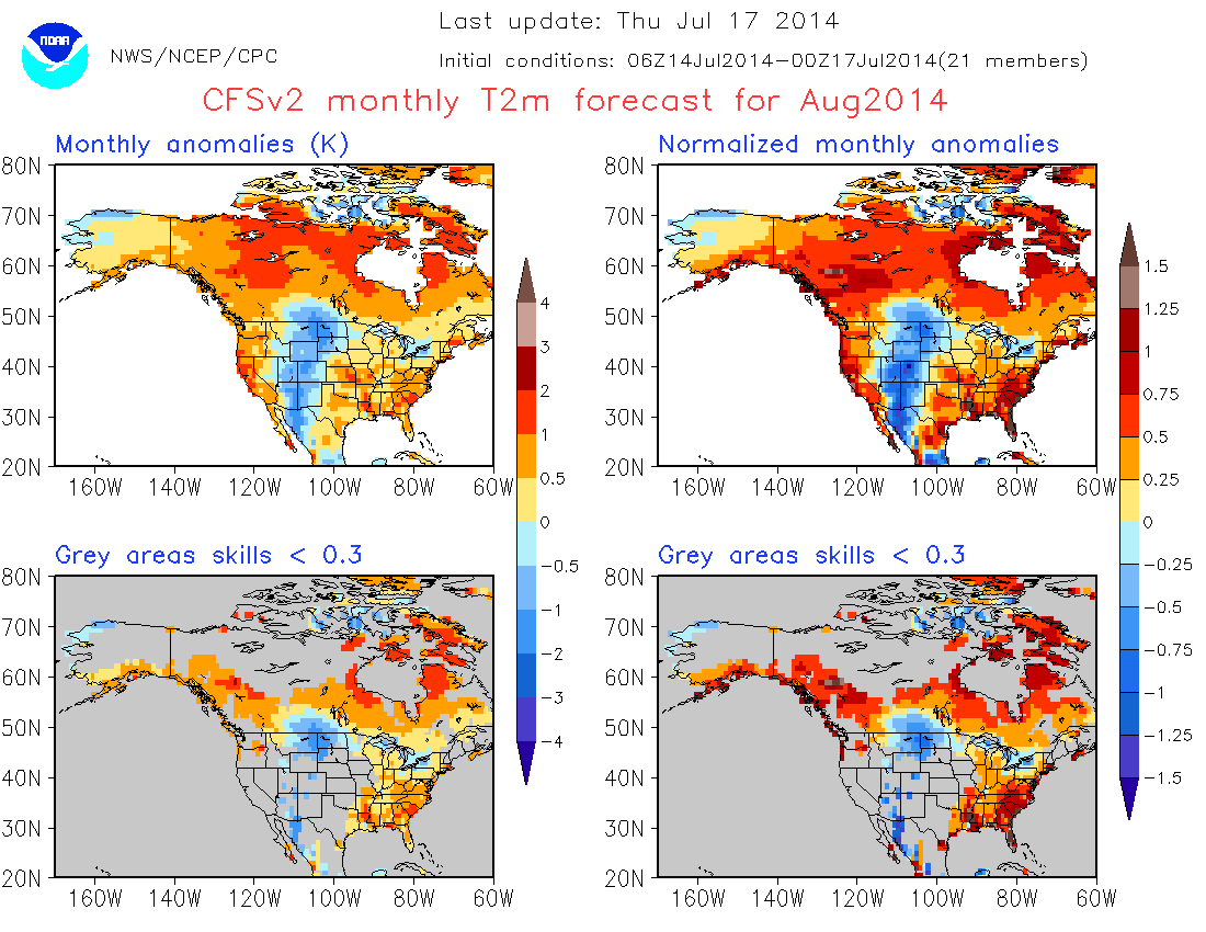
I’m not much of a fan of extended outlooks and/or long range forecasting.  Nevertheless, I do check a model that portends to go out weeks and months.  That model is known as CFSv2.  I like to see the slow, usually subtle, forecast changes the model picks up.  But today I noticed a big shock – a dramatic one week change in August’s outlook.

Below is the forecast from July 17.  The top left image is the raw computer output.  The upper right is a statistically “normalized” version of the raw data.  The bottom images are probabilities of occurrence.  Notice the eastern U.S.  Forecast for an above normal surface temperature (2 meters) is quite evident.

CFSv2Aug

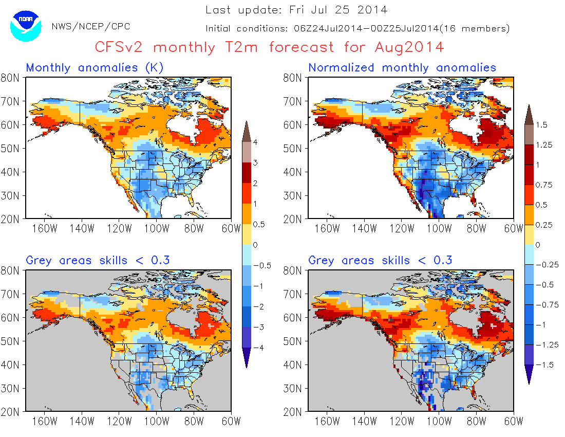
That was July 17.  Here’s the same image from today’s run…

CFSv2AugNEW

An amazing flip-flop!  If correct, we’re looking at a very nice August.  But, if it flips once, it can flip again.  This is a perfect example why I don’t like forecasting beyond 3 days.

Scoping out the weekend weather

Friday Morning

It’s like a three ring circus today – three models, three different solutions.  Trying to put it all together, here are a few things I’m pretty confident about.  1).  Our weather should remain dry through 6 P.M. Saturday (except for a small possibility for a few sprinkles overnight).  2).  Severe thunderstorms appear likely tomorrow night over northern/central Indiana moving into Ohio by Sunday morning.  Severe chance for Louisville area looks to be very small as peak storm chance for us will come from about Midnight Saturday until 8 A.M.  Sunday.  3).  One thing the models do agree upon is expected rainfall from this system.  Yesterday they placed a 1″+ swath of rain over most of IN and KY.  Today’s forecasts have dropped that by more than half.  Now the models are putting a 1-2″ path generally from Indy to Cincinnati with rapid dropoff south of that line.

So this could be a very interesting, and frustrating weekend for us forecasters as many things could go wrong.  But, forecast the weather is what I do, so here’s what I’m thinking now:

This Afternoon:  Mostly sunny…high mid 80’s (low humidity)

Tonight:  Mostly cloudy and warm…a few sprinkles possible…low…72.

Saturday:  Partly cloudy, hot and humid…high…90

Sat Night:  Showers and thunderstorms likely, especially after midnight.  Strong gusty   winds possible..low’…70

Sunday: Showers/thundershowers ending by late morning, then partly cloudy and warm…high…86.

Stuff

Pigs and humans are in a select group – we are the only two species who get sunburns.

Three may keep a secret if two of them are dead.  (unknown)


Pleasant again

Thursday Afternoon

Yesterday’s showers danced around the area with little to show for their efforts.  One exception was a narrow area of .25″+ rain from near LaGrange eastward into western Henry County. I have my sprinkler running right now.

Meanwhile pleasant weather will continue through tomorrow although it’ll be a little warmer in the afternoon.  The weekend should get off to a pretty good start – partly cloudy, upper 80’s and more humid on Saturday.  Then, we’ll begin to feel the effects of yet another upper air trough digging south into the Great Lake and Ohio Valley regions.  We’ve seen a lot of these systems this summer and have enjoyed the cool weather they’ve brought.  But, although they look very promising for rain several days in advance, lately they have failed to deliver on that promise.  Currently, the models are painting a large stripe of 1″ plus rains over the area.  But, even now, the models are putting some “red flags” on the rain outlook.  They are locking in on Midnight Saturday night until Noon Sunday as the preferred time for the most energy to be near us.  This time of year, that’s often a death trap for rain.  But, I’m sure there will be some changes to that outlook before Saturday.

Stuff – neat photo

Found the photo below from  www.spaceweather.com  Photographer was Stine Bretteberg and photo was taken in northern Norway.

sundog_strip

We are accustomed to the sun rising in the east and setting in the west.  But it’s not that way over all the earth.  Over polar areas of the Northern Hemisphere the sun never sets on the date of the Summer Solstice (usually June 20 or 21) and for several weeks either side of that date.  It’s commonly known as the Land of the Midnight Sun.   So, if the sun doesn’t set, what does it do?  It goes around and around in circles.  It starts in May as the sun hugging the horizon.  Each day until the solstice, the sun gets higher in the sky as it circles around the horizon.  After the solstice, it slowly winds back down.

The photo was taken around midnight with the sun sitting on the horizon while a layer of ice crystal clouds (cirrostratus, for Latin lovers) is in the sky.  As a result, several optical features all appear together.  First, the midnight sun; second, A large halo around the sun; and third, a set of sun dogs (parhelia) sitting in the halo at the horizon.  The Sun Dogs are the bright spots (often they have the colors of a rainbow faintly displayed) seen near the horizon directly east and west of the sun.

Addendum (also for my Latin speaking friends)

Talking about the sun’s behavior at high latitudes brings to mind an old story from a college textbook.  It seems an agricultural group , upon hearing about the sun’s polar activity, decided that would be the ideal place to raise sunflowers.  So they packed up some gear and headed off to the Land of the Midnight Sun and set of a greenhouse and planted their sunflower seeds.  At first, everything went well – the plants grew quickly and were tall and  e healthy.  Then, when the flowers started to grow, they did what sunflowers do – they followed the sun around and around and around until they slowly strangled themselves to death!

Holding out hopes for rain

Wednesday Morning

Little change from last night.  A large area of fading showers from overnight is approaching the Ohio River now (11 A.M.).  Looks like it’ll die out before it brings any rain to Louisville.  There will be a second chance for some rain and possibly a few claps of thunder between about 2P.M. and 5P.M.  In general, any rain should be light and spotty.  Drier, cooler weather returns tomorrow.

Wednesday forecast update

Tuesday evening

With the afternoon runs in, the models are bunching even closer.  The GFS has added some speed so it’s forecast time now runs from about 2P.M. to 7 PM.  Just a couple of hours later than the other models.  The short-term RAP model is now within range and it also likes the earlier time – about Noon to 3P.M.  The Model Output Statistics (MOS) data is also trending downward.  Only one model even reaches a 40% (6-hour) chance for rain while the others are only in the lower 30s%.  So, it continues to look as though this system certainly is not going to be noteworthy.   Probably little, if any, help for our parched lawns.