Category Archives: forecast

As the weekend approaches so does rain, but does it get here?

Thursday Afternoon

The pleasant weather of the past few days will be fading away as more typical July heat and humidity.  As mentioned yesterday, the GFS and NAM models were pretty wide apart concerning the possibilities for rain over the weekend.  Today’s runs show a definite shift by both models.  The NAM has made a big shift toward yesterday’s GFS while the new GFS has made a small jog toward the NAM.  So as of now, they are pretty much on the same page.  Both models return rain/t-storms to the Ohio Valley tomorrow night with the emphasis over southern and eastern KY.  These showers are not likely to reach as far north as Louisville or southern IN.  Showers/t-storms should linger over eastern KY (east of I-75) Saturday morning.  Then, a typical very warm and humid summer afternoon follows.  Sunday’s outlook remains the same.  Most likely hot and humid, but the GFS still is hinting at some t-storms late in the day.  Best chance still looks like south and/or east of Louisville.  Good news for Forecastle.

2014 temperature update

After the cold start to the year, our temperatures have warmed (compared to average) for the past few months.  But, July has hit the downward through the first half.  With a mild El Nino building in the Pacific, a good bet for the rest of the year would be for temperatures to be a little above average.

2014 so far…

  1. January  -6.3
  2. February  -5.9
  3. March  -3.9
  4. April   +1.9
  5. May  +2.0
  6. June  +2.2
  7. July  -2.6  (so far)


July at its Best

Wednesday midday

Pleasant weather continues…another nice pause from the usual July heat and humidity.  So far this summer we’ve seen several times when the heat/humidity build and then fade away after 2-3 days.  That’s been the dominant pattern since May and current forecast models continue the trend.  That would be nice, but I’ve never had much faith in long range predictions.

Current forecasts are concentrating on growing chances for showers/thunderstorms over the weekend.  The NAM model hits it pretty hard for Saturday rains while the GFS doesn’t buy that idea.  The GFS “hints” at a small chance for showers late Sunday.  In my experience, at forecasts beyond two days, the GFS seems to have a better handle on things, so I wouldn’t be too concerned about a wet weekend (at this point).

Blatant Unsolicited Promotion

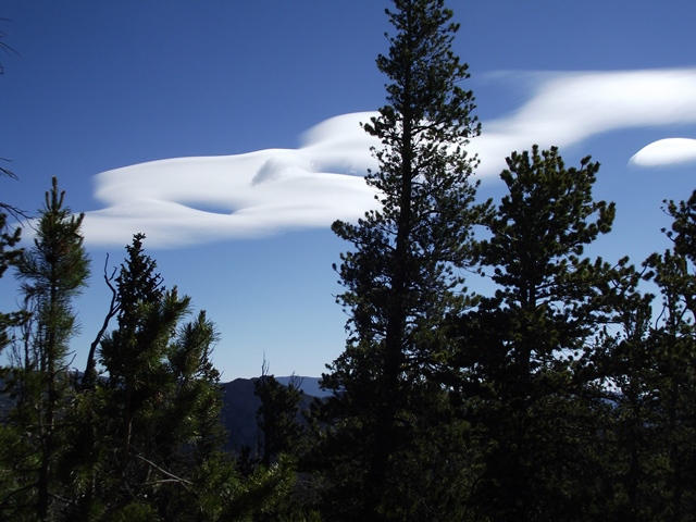
Yesterday’s post featured a couple of beautiful photos of Rocky Mountain cloud formations.  They were sent to me by some friends who were on a business trip to Colorado.  Their business: hiking.  They’ve recently launched a third web site…RockyMountainHikingTrails.com.  More than everything you’d ever want to know about hiking in Rocky Mountain National Park (one of my  favorite spots on Earth)  and surrounding areas is on the site.  Their two other sites are HikingintheSmokys.com  (a little closer to home) and HikingGlacier.com.  Don’t leave home without them!

Hype and Happenstance  (not by Jane Austin)

The recent Typhoon to strike the Philippines has been largely ignored by the media.  But it brings to mind the incredible hype about the “Super Typhoon Haiyan” last fall.  Strongest storm ever…220 miles per hour winds…another result of climate change…and on and on.  All these “reports” came out during or in the immediate aftermath of the event.  The images of the death and destruction were truly horrible, but  unfortunately not unusual for an underdeveloped nation.

But a few months later, after things had settled down, the real story of Typhoon emerged.  In the Philippines, any typhoon that produces winds over 140 mph is called a Super Typhoon.  Haiyan just managed to make the list.  Maximum winds recorded over land reached 147 mph.  The Weather Service of the Philippines ranks Haiyan as 7th on their list of strongest typhoons over the past 60 years.  So, Haiyan wasn’t the strongest storm ever, it just barely reached the Phillipines’ “Top Ten”.

My guess is that probably everybody reading this already knew the information in the first paragraph.  How many of you knew the 2nd paragraph’s info?  BE VERY,VERY WARY OF THE HYPE!

Calm Weather Ahead

Tuesday afternoon

Cool, dry high pressure has once again moved over most of the eastern two-thirds of the U.S.  Pleasant weather today should return again tomorrow and Thursday looks pretty good as well.

deer 066deer 082

The photos above were sent by a friend who took these in the Rockies in June.  Her basic question was “What are these, I’ve never seen anything like this.”

These are some of my favorites from when I was in grad school in Colorado.  You only see them in mountainous areas.  These are officially called altocumulus lenticularus.  (higher altitude versions are called cirrocumulus lenticularus)  More common names are “lens clouds” or “cap clouds.”  Another common description is “standing wave clouds.”   The “lens” or “cap” feature is very clear on these photos.  The best example is the left side of the lower picture.  Three good ones are on the top picture…one just to the left of the tall center tree…on the left edge of the photo and a small one of the right edge.  The cause of these clouds is the barrier of the mountains.  On days when the upper level winds are generally from the west AND there is just a little moisture on the air west of the Rockies (a pretty common experience,  the air approaching the mountains between roughly 10,000 and 15,000 feet is forced to rise to get over the top of the mountain range which in Colorado is about 13,000 to 15,000 feet.  This forced rising/cooling of the air condenses moisture only at the very top of the ridges, then fades away quickly as the air descends east of the mountain crest.  This little bit of cloud formation gives the “lens” and/or “cap” nature of the clouds.  The standing wave cloud  gets its name from the observation that the clouds do not move.  You can watch them for hours and they still look the same.  In reality, the cloud is changing rapidly – constant supply of the rising and keeps building the cloud from the west while the sinking motions to the east evaporate parts of cloud trying to move off the mountain tops.  So, the clouds “appear” to stand still.

On days when the conditions are almost perfect, in addition to the clouds standing on the mountain peaks, you may see as many 1-4 additional lines of “cap” clouds standing east of the hills out on to the plains.  That’s even more spectacular!

Update from yesterday

Midday Monday

Since yesterday there have been a few changes in the models, so here are a few updates on what to expect tonight and tomorrow.
First, the three models I follow have meshed into general agreement with the primary change since yesterday’s post being a general delay in the storm activity. As expected, all models have pretty much dropped the idea of afternoon thunderstorms here, but south-central Indiana could get hit by by 6P.M. There is still a small (30% chance) for thunderstorms in the area from 8pm until midnight.
That’s when the biggest change occurs. Original thinking had the big cluster of storms in our area between midnight and 6am. Now it appears that cluster won’t arrive until 6am until Noon. As these clusters (mesoscale convective complexes, for those who really want technical talk) normally fade fast during those hours, that. certainly greatly reduces any severe storm threat. It also reduces the amount of rain we should get. The Weather Service’s precipitation unit predicts almost two inches for us, but with the delayed timing I feel we’ll be lucky to get half that much. In fact, a few signs are popping up that a half inch might be a better estimate. My garden could use a good soaking, so I hope it doesn’t drop below a half inch.
The models agree that any strong upper air energy will pass us by Tuesday Noon. So, any lingering showers should fade quickly during the afternoon.

Humidity returns along with a chance for thunderstorms

Today marks five days in a row with high temperatures in the 80’s. Pretty good for July. And it appears we’ll see another 2-4 this week. The Storm Prediction Center has placed us under a slight risk area for “tomorrow” but don’t worry about that. The outlook is for Mon 8A.M. until Tue 8 A.M. The small concern is for the last 6-8 hours of that time.
All three models (GFS, NAM and HIRES Nam) are in good agreement for that 8PM-8AM period tomorrow night. But they differ before and after that. All three bring a weak upper level disturbance over us around 8 A.M. Monday, but there won’t be much moisture with it so the chance for rain will be very low. That system will bring in plenty of moisture so after the morning clouds move away, we’ll see a mostly sunny, hot, and humid afternoon. That’s when the first difference shows up. The GFS is fairly generous with a round of thunderstorms after 6P.M. The NAM models are basically ignoring any major chance for thunderstorms until after midnight. The “official” forecast which most broadcasters use has a 50% t-storm chance tomorrow. I’d say 20% is more realistic.
All three models bring in a stronger upper air system tomorrow night…best timing for Louisville area will be Midnight through Noon Tuesday. Moisture will be plentiful and energy abundant, so a large cluster of t-storms/rain appears likely during that time frame. If we’re going to see any severe storms it would be around 2-8A.M. Historically, those are hours fade and/or die, Let’s just hope we get some good soaking rain.
After Noon Tuesday, the GFS once again breaks away from the NAM models. The NAM essentially has everything wrapped up by Noon with cooler, drier returning for a few days. The GFS slows the system to allow another (fairly weak) outbreak of showers/t-storms late afternoon/evening.

Here’s how I see it in forecast form:
Tonight: becoming partly cloudy after midnight. Warm, with a low near 70.
Monday: mostly cloudy early followed by a sunny, hot and humid…high…92.
20% chance for a late afternoon thunderstorm.
Monday night: Showers and thunderstorms likely, especially after midnight.
low near 67.