Category Archives: commentary

Windy…yes. Stormy…maybe.

Tuesday, 2/2/2016

First, the Wind Advisory…

...WIND ADVISORY IN EFFECT FROM 1 PM THIS AFTERNOON TO 7 AM EST
WEDNESDAY...

.THIS AFTERNOON...CLOUDY WITH SCATTERED SHOWERS AND
THUNDERSTORMS. HIGHS AROUND 70. SOUTHEAST WINDS 10 TO 20 MPH.
GUSTS TO AROUND 40 MPH IN THE AFTERNOON. CHANCE OF PRECIPITATION
40 PERCENT.
.TONIGHT...BREEZY. SHOWERS AND THUNDERSTORMS. SOME THUNDERSTORMS
MAY PRODUCE DAMAGING WINDS. LOWS AROUND 50. SOUTH WINDS 10 TO
25 MPH WITH GUSTS TO AROUND 40 MPH. CHANCE OF PRECIPITATION NEAR
100 PERCENT.

Now, here is the NWS definition for a Wind Advisory…

Wind Advisory

A Wind Advisory is issued when the following conditions are expected for 3 hours or longer.

1) sustained winds of 31 to 39 mph    

AND/OR

2) wind gusts of 46 to 57 mph.

Notice anything unusual?  Yes, the forecast doesn’t came anywhere close to the definition.  And, this is the third time they’ve done this in the past couple of months!

So, let’s put it this way…it’s going to be noticeably windy this afternoon and tonight.  But, Wind Advisory criteria?  Very doubtful.

Severe weather situation

As a massive winter storm moves slowly NE out of Kansas toward the western Great Lakes, a major outbreak of severe storms is expected along the Mississippi Valley late this afternoon into early evening.  The western third of KY and southwestern IN could be hard-hit.  But for the Louisville area the situation is much different.

As is often the case with winter severe storm outbreaks, the dynamics (wind fields, etc) are very strong.  But the thermodynamics (temperatures, moisture, etc) are weak.  Sometimes, the dynamics can overwhelm the weaker thermo and wreak havoc.  That is expected late this afternoon and early evening along and near the Mississippi River.  Severe storms and some strong, long track tornadoes appear possible.

During that time, the thermodynamics will be at their peak.  But, the models never bring any positive thermos into central KY or southern IN.  Any instability dies quickly to our west after 6 P.M.  As the cold front slowly advances eastward, the expected severe storm areas consolidate into the line of gusty winds and very heavy rainfall as it approaches the I-65 corridor.  Biggest threat for our area should be flash flooding.  It’s possible we could see 2″-3″ of rain in a few hours, so watch out for flooding in low-lying areas.  If flooding is going to occur, it should be Midnight or later

As for the timing of the windy, rainy and possibly stormy weather…  For the Louisville area, the primary squally system should pass the area between 10 P.M. and 2 A.M.

Note:

The definition of the severe thunderstorm is Winds reaching 58 mph or higher and/or one inch hail.  I don’t believe either of those items will occur in the Louisville area tonight.  NEVERTHELESS, I do believe a Severe Thunderstorm Warning will be issued locally.  After all, can anybody remember the last time a moderate to strong line the thunderstorms has passed Louisville WITHOUT a warning being issued?  (It’s kind of like that Windy Advisory thing.)

Stuff:

I was happily impressed with the Cardinals win over UNC last night.  Good testament to the character of the team to bounce back from Saturday’s game with UVA.  It also speaks well for a team, such as UVA, that can completely change a game with their exceptional defense.

January thaw has late arrival.

Thursday 1/28/2016

Weather update:

After a couple weeks of wintry weather, a common January weather feature is entering the game – the January Thaw.  For centuries, weather watchers have noticed a tendency for a period of milder, calmer weather to hit the eastern half of the U.S. during the latter part of January.  This year (it doesn’t happen happen every year) it’s a bit late. We’ve been experiencing a rather weak example of it this week, but it’ll really kick into action by the weekend.  Temperatures could reach 60 or so then, but it’ll be even warmer early next week when even 70 degrees is not out of question. A strong storm will come out of the southwest early next week and move northward through the Mississippi Valley.  That will bring us strong southern winds and warm, rainy weather Tuesday and Tuesday night.  That’ll be it for this year’s “Thaw” as wintry conditions will return by midweek.

The “10 year deadline” has passed.  Why are we still here?

It was 10 years ago this week when former Vice President Al Gore made his (at the time) famous proclamation that if we didn’t make drastic efforts to end global warming in the next 10 years, Earth was doomed.  Well, the years have passed, Earth hasn’t warmed (according to satellite data), we haven’t done much to reduce the supposed enemy – carbon dioxide, and everything seems to be rolling along smoothly.  Of course, Al’s made a fortune acting as the shill for some climate fanatics, so he’ll be well prepared when the end arrives.

If you’d like more detail on Al’s proclamations and predictions, check out this article from the climate website Watt’s Up With That?   http://wattsupwiththat.com/2016/01/25/state-of-the-climate-10-years-after-al-gore-declared-a-planetary-emergency-top-10-reasons-gore-was-wrong/

2015 – Hottest Year Ever?

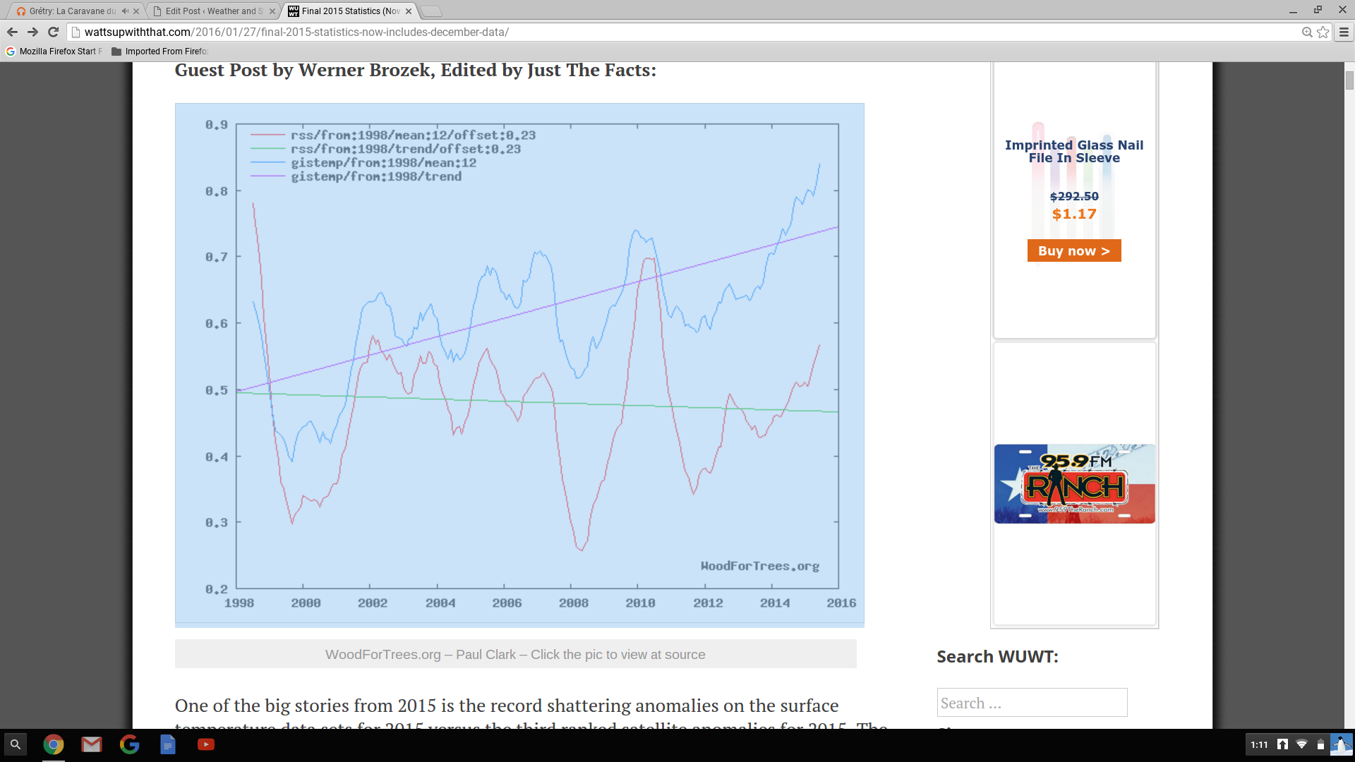
Last week our government announced NOAA ‘s and NASA’s findings that 2015 was the warmest year on record.  This is based on their analysis of global surface data that they have “adjusted” so many times as to be barely recognizable.  But, it fits the agenda.  Interestingly, our government also pays two groups to measure Earth’s temperatures.  Have you ever heard satellite data discussed during their “hottest this, warmest that” press conferences?  No, I didn’t think so.  The two satellite groups are GSS (Global Satellite Services) and UAH (University of Alabama-Huntsville).  The satellite global temperature surveys began in late 1978 and have closely matched each other over the years.  Why haven’t you heard about them?  This graph shows you why… Screenshot 2016-01-28 at 1.11.58 PM    Satellite data doesn’t support the agenda.

Odds and Ends

Monday, 1/24/16

Such arrogance

I saw in Saturday’s paper that the National Weather Service, in commenting on Friday’s (lack of) snow, said that the storm had “underachieved.”  I was dumbfounded!  They didn’t blame the lack of snow on a bad forecast (it was) or on the “models” (they did a pretty good job).  Rather, they blamed the lack of snow on…nature itself!  Nature doesn’t make mistakes, it always does what the physical laws dictate.  So, what happened was EXACTLY what nature intended.  The storm neither “underachieved nor “overachieved.”  It achieved exactly what it was supposed to.   When you look at the snow left behind over the eastern U.S., it is hard to say the storm “underachieved.”

Unfortunately, such arrogance runs rampant through many of our government science-oriented agencies.  From NOAA, NASA, EPA and all the way up to our scientifically gullible President the thought exists that we (mankind) have to stop nature RIGHT NOW!  If we don’t, the planet is going to kill us all.  Nonsense!!!  Who’s to say what the Earth’s average temperature should be?  Our climate always changes, has been for millions of years.  Warm spells, ice ages…it hasn’t mattered.  Life goes one, but it, too, changes.  Estimates suggest that about 97-98% of all the species that have developed on Earth are now extinct.  (Anybody ever hear of a man named Darwin?)  In more recent times, we believe Earth was warmer than now around Biblical times and again for 300-400 years centered around 1050.  Then we had the “little Ice Age” which ended in the mid 1800’s.  Since then, we’ve had an irregular, slow warming.  Over the past 100,000’s of years, what have humans done to survive?  They have adapted to the changing climate.  Or, perhaps a better word to use is (one of my favorites) ACCLIMATIZED.  They have adjusted to the changes in climate.  Now, all of a sudden, that won’t work!  We, as the human race, must stop nature in its tracks!  Our governmental gods say it can be done and have told us how.  They seem to think that we won’t notice if our economy is destroyed and our life style is set back about 100 years, or so.  Such arrogance!

We’ve already wasted trillions of dollars for projects that have given very limited results.  Solar and wind can generate power, but at a cost two to ten times higher than traditional power. (Your tax dollars are paying for that illogical economics.)  Plus, wind and solar need backup “traditional” power supplies because that have “down” times – night and calm winds.  A far, far better use of all that money would have been to rebuild/improve our nation’s infrastructure.  But, no, say our leaders, we can stop nature.  Good luck with that.

But, a happier note (maybe)

Although we humans have greatly altered and changed nature in our time on Earth, nature doesn’t really care.  It just follows the new rules and keeps on going.  The current El Nino has warmed Earth this past 6 months and will ease only slowly over the next 6-9 months.  Meteorologists who study Earth’s climate have studied and observed how climate has shorter term cycles in the weather/climate cycle that the current scare- mongering climatologists ignore.  They say the items are insignificant and are not included in any of the climate models predicting doom and gloom.

Many meteorologists (myself included) believe that plots of two of the items show a much higher correlation to reality than any climate computer model currently used.  Based on these items (ocean currents- major and sunspots- minor), we believe that Earth’s temperatures are due for a return to cooler temperatures after the current El Nino ends (late spring).  The ocean currents and low sunspot numbers, we believe, will provide a cooler Earth for the next 10 to 20 years

Just can’t let this go by…

From yesterday’s CJ…Charles Barkley on Chicago Bulls’ Jimmy Butler…

“Other than LeBron James, he’s been the second-best player in the Eastern Conference all year.”

(As a person who made a living ad-libing, I know how easily this can happen.)


OMG OMG OMG

6 P.M. Fri 1/22/2016

I am flabergasted at the new NWS forecast…just cannot believe it.

A few more tenths of an inch possible before this wraps up by 7-9 P.M.  But, we’ll see plenty of blowing and drifting snow tonight.

3 P.M. update

Friday, 1/22/2016

Snow intensity is winding down. but periods of light snow should continue until around 7-8 P.M. Radar shows the northern edge of the light snow is slowly drifting from southern IN toward Louisville.  It’s going to be tough to measure from here on out because of the strong winds and blowing snow, but any additional accumulations will be less than one inch for the Louisville area.

Snow totals appear to be highly variable, but nothing extreme.  At SDF the snow depth was measured at 7 A.M. and showed 3″ and at 1P.M. the snow depth was also 3″.  My driveway had 2.4″ around 1 P.M. and little snow since then.

It’s hard to imagine the NWS is still maintaining the Winter Storm Warning and the 4″-6″ snow forecast for Louisville.

But then, as Yogi Berra famously  said, “It ain’t over ’till it’s over.”

How much snow?

Thursday morning, 1/21/2016

Quick update after a glance at morning GFS and NAM model runs.  The trends remain the same as yesterday afternoon’s update mentioned – the primary storm track still looks to be on a track too far south to bring the really heavy snows as far north as the Ohio River.  Things are running a little slower as snow may hold off until around late morning or Noon tomorrow. (Makes the Winter Storm WARNING going into effect at 7 P.M. tonight look rather silly, doesn’t it? )

Still looks about the same – 3″- 5″ or 6″) in Louisville area.  Rapidly increasing totals up to 6″-12 south of the metro (across central KY).  Rapid drop in accumulations north of the Ohio.

More later.

Observations from this week’s snows

Thursday, Jan.14, 2016

The two snows this week pointed out a couple of interesting items: (1) The time and temperature that snow falls is very important and (2) the difference between “snowfall” and “snow accumulation.”

First, according to airport (SDF) data, the two systems had approximately the same liquid water content, so all things being equal we should have had about the same results.  But, we certainly didn’t.  Sunday’s snow fell during rapidly falling temperatures (from above freezing into the 20’s.  The warmer roads, at first, melted the snow.  As it got colder, the roads froze into icy sheets with a thin layer  of snow on top.  Meanwhile, the snow which fell onto the grassy areas didn’t melt (because of no solar radiation at night) and accumulated up to around an inch locally. If that snow had fallen during the day, the result would have been much like what we saw Tuesday.

Tuesday’s snow arrived around daybreak, so it didn’t have the advantage of night to get a jump on accumulations.  Plus temperatures were above 32 degrees.  That snow continued most of the morning, including a strong snow shower around 11 A.M.  That snow shower, if it had occurred around, say, 6 or 7 A.M., would have created a huge mess on the roads.  But, it happened during the day and the roads just stayed wet.

Now, the snowfall vs. accumulation.  This can be confusing because when we forecast snow, we talk about the expected accumulation – how much will my ruler measure on a flat, NON grassy surface.  However, the National Weather Service reports two measurements- snowfall and snow accumulation.  As we saw this week, the two are NOT the same.

Sunday morning’s snow (at night) was right in line with expectations – the weather service reported .8″ of snowfall and 1″ on the ground.  Accumulations are rounded to the nearest inch, so a measured “on the ground” .5″ to 1.4″ would be reported as 1″, etc.

Tuesday, however, was a much different story.  The “official” snow on the ground at 7 A.M. was 1″.  Then came the snow.  It was daytime and temperatures were above 32.  The snow”fall” total reported by the NWS was 1.8″.  At 1 P.M. the officially reported accumulation on the ground was listed as 0.

Good illustration of the difference between snowfall and snow accumulation – we started with one inch on the ground, then a snowfall of 1.8″.  After it was over, we had less than a half inch of snow on the ground.

NOTE:  Situations like this allow almost everybody to proclaim a “correct” forecast.  Monday night, the NWS and many others forecast an accumulation of 1″-2″.  I wasn’t watching Tuesday evening, but based on past experiences, I’d say that a common comment went something like this…”just like we predicted, we had 1.8″ of snowfall…”  They may proclaim to be “correct”, but they were wrong!  And they are trying to convince you they were right.  So, if you are keeping score – give them two strikes instead of one.

There is a difference between snowfall and snow accumulation. although many times forecasters wish you didn’t know.


NOTE:  I don’t know why, but this post today brought to mind an old story circulating about our old “climate specialist” Al Gore.  As you probably know, back in 2007 or so, Al famously announced to the world that due to global warming,  the Arctic would be ice-free (In summer) and the polar bears would have vanished by 2013 or 2014.  Well, here we are in 2016 and the Arctic still has plenty of ice and polar bears.

The comment:  When Al Gore was born, Earth had 7000 polar bears.  Now there are only 30,000 left.


Milder for the weekend; warmer next week

Friday afternoon (Mar 6)

After a beautiful snow forecast, the NWS fell back into it’s recent trend of big-time errors on low temperatures.  Early yesterday, it was all about the record lows we’d be having.  Didn’t happen.  Didn’t even come close.  But, in fact, a record MAY have been set!

First, yesterday’s high, predicted to be 17, reached the mid 20’s.  But the crowning event was to be the low this morning.  (see yesterday’s blog)  Yesterday’s overnight forecast, issued at 3:41 P.M. predicted a low temperature of -5 to -10 degrees.  This morning’s low was 8 deg. ( In forecasting, an error of +/- 3 degrees is considered a “hit”.)  So, the official forecast had an error range from 13 degrees to 18 degrees!  In today’s world, a miss of 10 deg. or more probably only happens a handfull of times a year.  But, a miss of 18 deg. is  virtually unprecedented.  So, indeed, a new record may have been set this morning – worst low-temperature forecast ever.  However, I don’t imagine that such records are kept, so we’ll never know.

Weekend

Southerly winds and partly cloudy skies will contribute to dry, warming weather.  That’s good news for most of us, but not for those who live in flood-prone areas.  Highs in 40’s may sound good, but that’s still below normal for early March.  Next week we’ll have some days in the 50’s and some reach the 60’s.

Tonight…partly cloudy and cold…low near 20 this evening, then slowly rising temperatures overnight.

Tomorrow and Sunday:  partly cloudy with highs in the mid to upper 40’s.

More sleet than snow?

  Wednesday 11 A.M (Mar 4)

I see the Weather Service has started to back down on their snow forecast, so I suppose the media folks will as well.  However, I still think the NWS step backward is far too small.

Quick look at morning data runs confirms (to me anyway) that my forecast posted last night is right (almost) on target – 2″-4″ of snow/sleet by tomorrow morning.  However, I have one subtle change to make.  It looks to me that we’ll see a prolonged period of sleet this afternoon.  We could see up to an inch (or so) of sleet before a change to snow this evening, probably between 6 P.M. and 9 P.M.  After midnight, snow should begin to taper off to a few flurries by morning rush hour.

Another update this afternoon.

P.S. Why is JCPS closed today???

Temperature/Wind Chill apparently baffle NWS again

Sunday Evening

A post last week discussed the poor forecasting (and thus the badly misleading wind chill information) of overnight lows for Louisville last week.  Well, they are at it again tonight.

1).    Wind Chill Advisory from Midnight until 9 A.M. Mon A.M.  Okay, that’s the headline.  For Louisville, the Wind Chill Criteria for an advisory is -10 deg. to -25.

2),  The NWS forecast for Jefferson County is for a low of 8 degrees and a wind chill of +1 to -9.  The forecast doesn’t agree with the headline (Wind Chill Advisory)

3).  Once again, the NWS  forecast low (8) is far below available guidance.  Latest I’ve seen say either 13 or 14 degrees).  Even though the winds will be northerly (bringing us colder air), the models all expect a large amount of cloudiness to linger most of the night, reducing radiational loss.  Thus, to me the guidance looks to be much better.  I’ll give it a low of 12 by 8 A.M. tomorrow.  Assuming the warmer temperatures, wind chills will be even farther away from advisory “criteria.”

Week ahead

Weather remains very cold, but calmer conditions should return for most of the week.  The next two “major” storms should move across the Gulf Coastal states this week.  That’ll keep the big problems south of us.  A couple of northern stream disturbances will cross over us.  One tonight and the second late Tuesday.  Each one will serve to reinforce the cold weather, but will have only enough moisture to perhaps produce some snow flurries.

The third major storm to push out of the southwest this week should come in two sections.  The first (Friday) could bring a little snow but the major energy with the system should arrive Sat. night/Sunday.  Too early to tell whether it’ll bring rain or snow OR the whole mixed bag like this weekend.