Category Archives: stuff

Grasping at more straws

Thursday,Feb. 6, 2020

Light snow possible late tonight

Snow chances have been few and far between this winter.  We started with tad about an inch of grass-only snow in November and haven’t been able to match it since.  However, we’ll see two chances over the next two days.  Best chance for breaking past one inch will come Saturday morning.

A strong upper level trough is passing over today, but so far is having trouble with surface development.  That problem should end tonight as a major surface storm will be developing/accelerating northeastward along and just east of the Appalachians tonight.  Latest forecasts have the storm path a bit farther east than earlier models.  That’s bad news for the Louisville area.

We were expected to be in the western edge of snowfall from this system.  Now, it looks like we’ll be “really” on the edge.  Far southeastern KY could get up to 6″ overnight.  As you head northwest from there, snowfall will lessen.  Bowling Green, Lexington and NE KY should be in the 2″-4″ range.  E-town, Bardstown, Shelbyville, and Henry County will likely be in the 1″-2″ zone.  West of that, snow will fall off quickly. SE Jefferson County could get up to .5″ while downtown will probably get a dusting.  North of the Ohio River…little to nothing.

In the Louisville area, snow is likely to begin about 3-4 A.M. and probably be over around 7-8 A.M.  Any accumulations will be on grassy areas.  Roads should be wet, but icy conditions are likely on some bridges and overpasses.

As the upper trough moves eastward tomorrow, a (probably) weak Alberta Clipper will run southeastward along the backside of the trough.  Models are projecting another area of light snow with the clipper and put us in its projected path.  I’ll check back on that tomorrow.

Stuff

Together, Kobe Bryant and LeBron James played in every NBA Championship Finals from 2008 until 2018.  But, they never played each other.

Snow tonight

Not much, but it’s a good start

Monday, November 11, 2019

Forecasters and forecast models all seem to be on the same page with the cold front moving through this evening.  Late afternoon rain should change over to light snow between 7 – 8 P.M. around the metro area.  Snow should be light and be over by midnight.  Then a wintry blast of cold air takes over for a few days.

It’ll probably take about 1-2 hours after the snow begins before temperatures drop below freezing. Nevertheless, we’ll probably see a little snow on grassy areas – up to 1″ in colder suburban areas.  No more than a few icy spots on roads, especially bridges and overpasses.  No problems are expected for the morning rush hour(s).

Stuff:

No wonder squirrels seem busy these days.  It takes at least 100 acorns for an average squirrel to make it through a winter.


Much weaker than advertised

Ohio Valley part of storm fades

Oct. 21, 2019 4 P.M.

Since late last week I’ve been hearing all these horror stories about today’s weather – heavy rain, flash flooding, possible severe storms, strong winds, etc.

Well, Monday has arrived and only (mostly) one part of the forecast will be correct.  We have had strong winds – gusts in the mid 30’s.  Although we were led to believe they’d be about 10 mph stronger.

Periods of rain are likely through about 9 P.M. though total rainfall should be about a quarter-inch or less.   A little lightning will be possible around 8 P.M.  Winds will still remain gusty- gusts possible of 30-35 mph late afternoon but diminishing this evening.

Stuff

This situation brought back a story about a former WAVE weathercaster from waaaay back.  He had predicted the next day to be sunny, windy and warm.  Instead, we had a cloudy, cool, rainy and windy day.

His next broadcast began this way…”See, I told you it was going to be windy today!”

Really?!

Nit Picking

Noon Oct.9,2019

Just checked the afternoon forecast from the NWS.  Cloudy with a high in the upper 70’s.

Here we are sitting under cloudy skies, light NE winds at about 60 degrees.  How are we going to get almost 20 degrees of warming over the next 4-5 hours?  We’re not.  Even if the clouds cleared immediately, we’d be hard pressed to get that warm.  In reality, clouds should begin to thin by 3-4 P.M.  Even with thinning clouds, we’ll be lucky to reach the low 70’s.  Around 70 seems more likely.

What’s up?  Isn’t anyone paying attention?

Stuff

A little perspective…

Slashing and burning of the Amazon has been going on for decades.  All of a sudden this year, it became the “climate destruction gang’s” next big thing on the climate agenda.  But why now?  The  average amount of deforestation over the past five years has been only about 50% of what was occurring 20 years ago.

Don’t get me wrong on this, Amazon deforestation is (and has been) a big climate problem.  But, programs have been ongoing for years to reduce the burning.  Success has been modest, but this certainly is not a new problem.

More changes, this time it’s better news

Sat.  Aug. 31, 2019  3:30 P.M.

Much better news for Florida!

Over my 50+ years of trying to into harmony with nature, I repeated countless times, “Don’t trust any forecast beyond two days.”  We still miss forecasts in days 1 and 2, but that forecast is usually pretty accurate.  But when you get beyond 2 days, things change.

Hurricane Dorian forecasts this week have been  a prime example.  Early this week Dorian was projected to hit somewhere along the Florida east coast.  Where?  We have many different models looking at the storm (you’ve probably seen the “Spaghetti Diagrams” on tv), but the  U.S. showcase is the GFS and the top model in the world is referred as the EURO.  Let’s just track those two.

Early in the week, the GFS landfall was predicted to be along the FL/GA border.  The euro focused on southern FL.  Over the next day or two, the GFS gradually worked its landfall southward to close to the euro position.  Yesterday, the GFS still predicted a hit north of Miami then at least a two day journey northward over Florida.  That matches the horrific damage projection I mentioned Thursday.

But, yesterday’s morning euro changed!  It no longer predicted Dorian to hit Florida.  Instead, it would get within a 100 miles or so, then turn slowly northward along the coast and probably not hit land until about North Carolina.  That’s VERY important!  As far a potential damage goes, there’s a huge difference between a hit and a near miss.  Meanwhile, the GFS maintained it’s devastating forecast.

This morning, the GFS caught up to the euro  with the “close miss” scenario, but was still putting landfall along the area along the North/South Carolina border.  Today’s euro, however, has shifted the storm track farther east, possibly even missing the Outer Banks.

So, what’s going to happen?

Good question.  We’re still more than two days away from U.S. coastal interaction and “trends” sometimes do reverse.   So, no one from Florida to North Carolina is completely out of danger yet.   But, current trends are indicating a much better situation, especially for Florida.  As it stands now, Florida’s biggest threat will come from beach erosion.   But remember, things change!

GFS vs. euro

Remember earlier this summer when the National Weather Service made a big fuss over it’s introduction of its “new and better” GFS version?  The model was designed to oust the euro as world’s best.  Dorian has been the first big test for the new GFS.  So far, so bad.  But, things change.  Let’s see how it plays out.

Stuff

The director of the Internal Revenue Service during the mid 1940’s later went to jail for failing to pay his income taxes.

Barry “underperforms”

Tuesday, July 16, 2019  4 P.M.

Barry provides a wet night

Remember all the frightful forecasts about the flooding rains Barry would cause last weekend over Louisiana and surrounding states?  Well, the storm did produce the normal heavy rains that a tropical storm does, but the big weather story for the past couple of days has been Barry’s “underperformance.”  A huge part of the damage and destruction predicted never happened.  That’s the good news.  Here’s the bad news:  All the familiar meteorologists’s phrases popped up – “We dodged the bullet”, “We got lucky”, and “The storm underperformed”.  Ah!  The world we live in.  All the reasons given imply that the forecast was correct.  Thus, it was nature that blew it!

Note to fellow forecasters:  Nature does NOT make mistakes, but we do.  Isn’t it about time that forecasters actually own up to their mistakes and just admit them rather than trying to push the blame to “the weather”?

Barry’s moisture finally reaches us.

Barry’s remnants are being picked up by a weak upper air system over the midwest that will push eastward tonight and cross the lower Ohio Valley by midday tomorrow.  Ahead of this system we’ll see periods of rain and a few thunderstorms tonight.  There could be a few lingering light showers tomorrow, but the bulk of the rain will be overnight.  Current model trends are for the heaviest rains to occur over the western third of KY and over the eastern third of KY later tonight and tomorrow.  Both of those areas could see 1″-2″ rain totals with perhaps higher totals in the mountains.  Most of southern IN and central KY should receive up to an inch of rain with a few areas higher if thunderstorms develop.

Break in the heat coming?

For at least a month, the GFS model has been predicting a change in the upper air pattern over North America.  The forecast has always been for the shift/change to occur 10 days to two weeks ahead.  But “next week’s cooling” has never shown up…yet.

Late last week the forecast was for a transition to the cooler pattern to happen Sun/Mon (July 21-2).  Now we’re less than a week away and the forecast hasn’t changed.  Could it be “real” this time?  It sure looks like it.  So, a more comfortable weather pattern should set if next week.

Then, the question becomes whether the cooler pattern will persist for several weeks or just be  a minor “blip” in the summer heat.  Longer range models keep the cooler pattern in place for most of August.  We’ll just have to wait and see.

Stuff:

There’s been a lot of news and celebration this week concerning the 50th anniversary of the Apollo II moon landing.  Here’s a tidbit I read this week…

The Apollo II computer system required about 145,000 lines of code.   (Today, Facebook runs about 62 million code lines while Google uses more than 2 billion lines!)

Astronomical Spring arrives at 5:58 this evening

Wed., March 20, 2019

Is the Equinox equal?

The Spring (or vernal) Equinox arrives this evening as the sun will be directly above the Equator at 5:58 EDT.  And, even though the word equinox roughly translates into “equal night”, that’s not exactly true.  The common interpretation for the day of the equinox is 12 hours of day and 12 hours of night.   But if you look at the sunrise/sunset table, you’ll see today has 12 hours 8 minutes between sunrise and sunset.  So, day and night are not 12-12 as most people think.

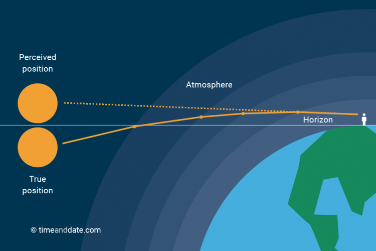
What accounts for the extra 8 minutes?  Our atmosphere! On its roughly 93 million mile journey to Earth, sunlight travels through a vacuum.  For the last 10-20 miles, however, the sunlight encounters a higher density medium (the atmosphere).  The closer it comes to the surface, the higher the density.  When light travels into a region of higher density, it bends.  This bending is properly called refraction.  Or, in the case of the sunlight and Earth, atmospheric refraction.

Courtesy: timeanddate.com

So, when we see the sun sitting on the horizon, it is actually below the horizon.  But, we still “see” the sun because the atmosphere refracts (bends) the sunlight back to our eyes.  From the time we perceive the sun on the horizon until it drops out of our vision, four minutes go by.

So, if the Earth had no atmosphere (we’d be in BIG trouble), sun rise and set would be exactly 12 hours apart.  Because we do have an atmosphere, you must add the extra 4 minutes at sunrise and four more at sunset. Thus, the day of the Equinox has 12 hours 8 minutes between sunrise and sunset

Full moon tonight

The March full moon is most commonly called the Worm Moon (think robins in the early spring).  It has many lessor known names as well…Lenten Moon,  Crow Moon, Crust Moon, Chaste Moon, Sugar Moon and Sap Moon.

Our moon will be “full” at 9:42 P.M.  Moon rise tonight at 7:38 PM EDT.

Wait, one more thing…

Just trying to wrap things up in a neat little package…

Q.  Why does the moon look much larger near the horizon than it does higher in the sky?

Ans:  atmospheric refraction (plus something called the apparent shape of the sky)                         Note:  The moon on the horizon problem is still considered as the Moon Illusion.  People have been trying to explain it for over 2000 years.  Ptolemy was one the first to try.  His suggestion was very similar to the one I gave above.  But, it’s still under debate.

Severe Storm “potential”, take 3

Wed., March 13, 2019  6 P.M.

Thunderstorms likely tomorrow

This is the third time in recent weeks that the Storm Prediction Center(SPC) has put us in an area of potential severe storms.  We are in a “slight risk” region tomorrow.

The first two times, the situation was the same.  Very strong dynamics (wind fields) but little support from the thermodynamics (heat and humidity).  As the old song goes, it takes two to tango.  Both times, the partnership never happened, so the weather didn’t get to dance.

As is common in the early spring, the (almost) same situation exists again.  But, there are some differences.  Strong dynamics (upper winds, strong surface storm) are once again the prominent feature.  But, the dynamics over the midwest/Ohio Valley will be weakening through tomorrow.  Northward flow of heat and humidity is currently strong, but it also is expected to weaken.

So, overall the threat for severe storms over KY and southern IN tomorrow looks pretty small.  The GFS is weak with storm development while the NAM is a little stronger and more in line with the SPC ideas.  However, it keeps storms pretty weak over KY, but does point out a stronger threat over the northern two-thirds of IN tomorrow afternoon.

Here’s my forecast:

Mostly cloudy and breezy tonight…low…58.  70%  chance for showers and/or thunderstorms after 4 A.M. continuing into mid-morning.  (Rain/storms will be most likely along and west of I-65.)

Another area of showers and thunderstorms will likely cross the area between 4 P.M. and 7 P.M.  tomorrow.  Gusty winds around thunderstorms, but severe weather threat is quite low.  Cooler weather arrives Friday.

Stuff

Tomorrow is Pi Day.  3.14 on the calendar.  Use some math, it won’t hurt (much).


Calmer weather for a couple of days

4 P.M. Feb. 20, 2019

Ohio River on the rise again.

Current hydrological forecasts have the Ohio in Louisville rising to just a inch or so from flood stage by Monday morning.  In the short term, I think that forecast will be revised downward since rainfall last night and today has fallen, in general, a half-inch to one inch shy of forecasts.  Plus, the highest amounts (southwestern Indiana) fell in areas that will drain into the Ohio downriver from Louisville.

Mostly light rain will move east of I-65 by 6-7 P.M. this evening.  Then two dry days lie ahead.  We’ll keep plenty of clouds around, but temperatures will reach about 50 tomorrow and a few degrees warmer on Friday.

Looking ahead

The next big storm to reach us will arrive Saturday and persist about 24 hours.  This one also projects as a big rain-maker.  Current estimates are in the 1″ to 2″ range, down a bit from earlier forecasts.  This storm will determine the fate of the Ohio River here in Louisville.  Another rain in the forecast range could easily put the river out of its banks by early next week.

Looking farther ahead

A lot has been said about an abrupt change back to a much colder pattern around March 1.  Call it “Polar Vortex, Chapter 2”!  Well, the GFS has been predicting some snow on arrival (now looks like Feb.28th) and a substantial snow about March 4 or 5.

Unfortunately, that all changed with this morning’s GFS.  It is now pushing much less cold air southward, as happened last time.  We could still have some light snow upon the cold air’s arrival, but it won’t hang around long enough to prevent the March storm from being rain.

DON’T give up hope!  The GFS has been acting very shaky (wild forecasts) since yesterday’s 18Z (1.P.M.) run, so it could all shift again.

Stuff

Of the world’s “big cats” (lions, tigers, leopards and cheetahs), only the cheetah cannot roar. They , however, can purr.  They also can accelerate to 70 mph in three seconds!


More heavy rain ahead, but first…

4:30 P.M. Monday, Feb. 18, 2019

Most likely rain will start as snow

A quick look at the primary weather charts today would give you the idea that there’s no chance for snow tomorrow night.  But, today’s forecast models allow you to dive much deeper – and they say we’ll see a few hours of snow/sleet before we warm enough for rain.

The  mid and upper atmosphere will warm rapidly tomorrow, but there be some air in the lower 5000 feet of the atmosphere that remains cool enough to create snow before rain takes over.  Even though surface temperatures should reach 40 or higher, the near surface air will remain very dry.  So, as precipitation begins aloft, it will be evaporated before it reaches the surface. Evaporation of water cools the air.  In this case, just enough cooling to allow the snow from aloft to NOT melt before reaching the surface.   Temperatures will probably only drop into the mid 30’s, so it’ll be a very “wet” snow.  Nevertheless, much of the area along and north of I-64 could easily see a 1″-2″ accumulation on grassy areas before the changeover to rain.  Areas south of I-64 will see a rapid drop in snow  – probably 30-40 miles south – should expect no accumulation.

Roadways may see a brief slushy period, but little (if any) accumulation.  Rain will wash away icy spots on the roads by shortly after Midnight, so no trouble with the morning rush – expect for water.  Rain tomorrow night until midday Wednesday should be add up to about 1″-1.5″.  While that’s a good sized rain, it will not be enough to bring back flooding.  After that the next heavy rain is not expected until Saturday.

Stuff

36 degrees    If something is falling out of the sky and it’s 36, there’s 50% chance it’ll be rain and 50% chance it’ll be snow (or some other frozen type).  Above 36, the odds increasingly move toward liquid.  Below 36, the odd increasingly favor frozen types of precipitation.