Monthly Archives: July 2014

Holding out hopes for rain

Wednesday Morning

Little change from last night.  A large area of fading showers from overnight is approaching the Ohio River now (11 A.M.).  Looks like it’ll die out before it brings any rain to Louisville.  There will be a second chance for some rain and possibly a few claps of thunder between about 2P.M. and 5P.M.  In general, any rain should be light and spotty.  Drier, cooler weather returns tomorrow.

Wednesday forecast update

Tuesday evening

With the afternoon runs in, the models are bunching even closer.  The GFS has added some speed so it’s forecast time now runs from about 2P.M. to 7 PM.  Just a couple of hours later than the other models.  The short-term RAP model is now within range and it also likes the earlier time – about Noon to 3P.M.  The Model Output Statistics (MOS) data is also trending downward.  Only one model even reaches a 40% (6-hour) chance for rain while the others are only in the lower 30s%.  So, it continues to look as though this system certainly is not going to be noteworthy.   Probably little, if any, help for our parched lawns.

Chance for rain is trending down…

Tuesday Afternoon

Not a lot of time today, so if you haven’t read yesterday’s forecast discussion, I’d advise you to start there.  Also, today’s weather reminds me of how much I HAVEN’T missed this type this summer.

Models have come into pretty close agreement today and now focus our  best chance for showers/t-storms tomorrow between 10 A.M. and 4 P.M.  Yesterday I mentioned the system to our south essentially blocking any significant moisture northward.  All models are hitting hard on that idea today.  The result for us adds up to less aerial coverage, reducing any severe threat to near zero and overall reduced amounts of rain.  By tomorrow evening,  cooler, drier air return for another couple of days.

Stuff

The famous quote, “Oh what a tangled web we weave when first we practice to deceive.” is usually attributed to Shakespeare.  But he didn’t write it.  Sir Walter Scott is the actual author.

Hot start to the week

Monday afternoon

It’s hot, but at least the humidity isn’t too bad.  Current dew point is 65, right on the bottom end of when humidity starts adding discomfort.  General rule is that dew points below 65 cause little problem for the majority of the population.  However, when the dew point rises above 65, the humidity really gets noticeable.  For this area, Dew points at 70 or above can make the air feel oppressive.  The dew point, by the way, is the temperature to which the air must drop for the air to be 100% saturated.  So, dew points are an absolute way to express moisture in the air.  The higher the dew point, the more moisture is in the air.  Relative humidity, a more familiar term, is highly variable and values change widely during most days.  I know you’re not supposed to define a word by using, but relative humidity really is “relative” (to the air temperature).  More on this at a later date, if anyone is interested – or even if you aren’t!

Back to the weather…there’s a large, weak upper air disturbance over the deep south that is bringing scattered showers/t-storms from the Gulf Coast as far north as Tennessee and east as far as the Carolinas.  This system has been cut-off from the normal wind patterns over the northern U.S.  As a result it is just drifting aimlessly.  Forecast models continue a general weakening trend with a WSW direction.   Thus, higher moisture will be trapped by this system and discourage northward movement.

That becomes the big question mark for our midweek chance for rain.  As usual, the NAM family and the GFS have their differences.  But, once again, none of the models is expecting much rain.  The NAMs are faster and stronger but bring in rain/t-storms during  the morning – the worst time for significant rain.  Meanwhile, the GFS holds off the rain/t-storms until about 4-10PM.  That allows time for more heating, but thunderstorms also need moisture.  That’s being trapped by the southern system.  Neither system holds out much hope for a decent amount (say, .50″ or more) of rain.

As I’ve mentioned before, beyond a day or two the GFS seems to be better.  So it looks like tomorrow and Wednesday should both reach the lower 90’s with a good chance of late day thunderstorms on Wednesday.

Commentary (and a bit of bragging)

As I write this, my wife and 12-year old granddaughter (Holly) are downstairs in the sewing room.  My wife sews a lot (quilt-maker) and Holly has always been fascinated and has been learning for years.  Today they are working on a charitable project called Dresses for Africa.  The original idea used pillow cases to make a quick and easy dress for young girls in Africa.  They made five a few weeks ago and are back at it again.  Here’s a picture of Holly’s first efforts.       016  
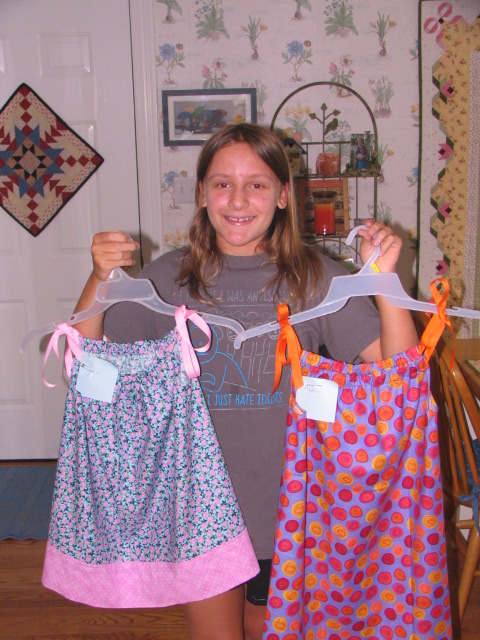
If you sew or know people might be interested, you can get all the information at www.littledressesforafrica.org.

A look at the week ahead

Sunday Evening

Now that the clouds have finally thinned out, it looks like typical hazy, hot and humid summer weather through most of Wednesday with daytime highs near 90 and nighttime lows near 70 with patchy fog.  Wednesday looks like our best chance for thunderstorms for the week.  A weak cool front should pass the area Wednesday night with the possibility of thunderstorms ahead of, and along, the front.

Later in the week, cooler, drier air returns for a few days.  After Wed. it looks like our next chance for rain won’t come until late in the weekend.

Stuff

When the popular soft drink 7up was first introduced(1929), its name was Bib-Label Lithiatated Lemon-Lime Soda.  The modern name comes from the 7 ounce bottles it came in plus the way the carbonation bubbled UP in the bottle.

More Stuff

I’m using a square bathtub now so I can’t get a ring.                                                                       unknown

Friday Update

Friday Afternoon

Models, and the actual weather, continue to bring the moisture farther north than anticipated.  Quicker, too.  We’ve had some very light showers in the area, especially along and east of I-65.  So far, it’s been mostly trace amounts.  The short-term RAP model continues to keep the western edge of the higher moisture right over the Louisville area until about 8 PM.  After that, any lingering showers should move away to the northeast.  Another chance for additional light showers tomorrow morning remains for about 8-11 A.M.  (Note: The “official” forecast for tonight and tomorrow mentions thunderstorms.  That’s just not going to happen)  (Note 2:  Rainfall tonight and tomorrow morning should be very light…averaging between a “trace” and a few hundredths of an inch.  Not enough to give a good soaking to our dry lawns and gardens.  More of a nuisance than anything else.)

Stuff

I drove by a gas station today and saw something I’ve never seen before.  Both the price per gallon for regular and diesel were exactly the same – $3.869.

More stuff

Show me a twin birth and I’ll show you an infant replay.                                                               unknown


Update for Weekend Weather

Friday morning

Quick update for the weekend.  Morning model runs agree pretty much with yesterday’s ideas…with one exception.  They drag moisture farther north.  The result requires a modification to my forecast.  Best chance for rain for the weekend will be this evening through tomorrow morning.  Could be (30% chance) some light showers – NO thunderstorms- after 6PM.  Then a second chance late tonight until about 8-10 tomorrow morning.  After that, dry weather should hold through the weekend.  Louisville area will be on the northern fringe of any rain.  Southern and eastern KY should have rainy weather tonight and most of tomorrow.  Weekend highs:  today near 80, mid 80’s tomorrow and upper 80’s Sunday.

As the weekend approaches so does rain, but does it get here?

Thursday Afternoon

The pleasant weather of the past few days will be fading away as more typical July heat and humidity.  As mentioned yesterday, the GFS and NAM models were pretty wide apart concerning the possibilities for rain over the weekend.  Today’s runs show a definite shift by both models.  The NAM has made a big shift toward yesterday’s GFS while the new GFS has made a small jog toward the NAM.  So as of now, they are pretty much on the same page.  Both models return rain/t-storms to the Ohio Valley tomorrow night with the emphasis over southern and eastern KY.  These showers are not likely to reach as far north as Louisville or southern IN.  Showers/t-storms should linger over eastern KY (east of I-75) Saturday morning.  Then, a typical very warm and humid summer afternoon follows.  Sunday’s outlook remains the same.  Most likely hot and humid, but the GFS still is hinting at some t-storms late in the day.  Best chance still looks like south and/or east of Louisville.  Good news for Forecastle.

2014 temperature update

After the cold start to the year, our temperatures have warmed (compared to average) for the past few months.  But, July has hit the downward through the first half.  With a mild El Nino building in the Pacific, a good bet for the rest of the year would be for temperatures to be a little above average.

2014 so far…

  1. January  -6.3
  2. February  -5.9
  3. March  -3.9
  4. April   +1.9
  5. May  +2.0
  6. June  +2.2
  7. July  -2.6  (so far)


July at its Best

Wednesday midday

Pleasant weather continues…another nice pause from the usual July heat and humidity.  So far this summer we’ve seen several times when the heat/humidity build and then fade away after 2-3 days.  That’s been the dominant pattern since May and current forecast models continue the trend.  That would be nice, but I’ve never had much faith in long range predictions.

Current forecasts are concentrating on growing chances for showers/thunderstorms over the weekend.  The NAM model hits it pretty hard for Saturday rains while the GFS doesn’t buy that idea.  The GFS “hints” at a small chance for showers late Sunday.  In my experience, at forecasts beyond two days, the GFS seems to have a better handle on things, so I wouldn’t be too concerned about a wet weekend (at this point).

Blatant Unsolicited Promotion

Yesterday’s post featured a couple of beautiful photos of Rocky Mountain cloud formations.  They were sent to me by some friends who were on a business trip to Colorado.  Their business: hiking.  They’ve recently launched a third web site…RockyMountainHikingTrails.com.  More than everything you’d ever want to know about hiking in Rocky Mountain National Park (one of my  favorite spots on Earth)  and surrounding areas is on the site.  Their two other sites are HikingintheSmokys.com  (a little closer to home) and HikingGlacier.com.  Don’t leave home without them!

Hype and Happenstance  (not by Jane Austin)

The recent Typhoon to strike the Philippines has been largely ignored by the media.  But it brings to mind the incredible hype about the “Super Typhoon Haiyan” last fall.  Strongest storm ever…220 miles per hour winds…another result of climate change…and on and on.  All these “reports” came out during or in the immediate aftermath of the event.  The images of the death and destruction were truly horrible, but  unfortunately not unusual for an underdeveloped nation.

But a few months later, after things had settled down, the real story of Typhoon emerged.  In the Philippines, any typhoon that produces winds over 140 mph is called a Super Typhoon.  Haiyan just managed to make the list.  Maximum winds recorded over land reached 147 mph.  The Weather Service of the Philippines ranks Haiyan as 7th on their list of strongest typhoons over the past 60 years.  So, Haiyan wasn’t the strongest storm ever, it just barely reached the Phillipines’ “Top Ten”.

My guess is that probably everybody reading this already knew the information in the first paragraph.  How many of you knew the 2nd paragraph’s info?  BE VERY,VERY WARY OF THE HYPE!

Calm Weather Ahead

Tuesday afternoon

Cool, dry high pressure has once again moved over most of the eastern two-thirds of the U.S.  Pleasant weather today should return again tomorrow and Thursday looks pretty good as well.

deer 066deer 082

The photos above were sent by a friend who took these in the Rockies in June.  Her basic question was “What are these, I’ve never seen anything like this.”

These are some of my favorites from when I was in grad school in Colorado.  You only see them in mountainous areas.  These are officially called altocumulus lenticularus.  (higher altitude versions are called cirrocumulus lenticularus)  More common names are “lens clouds” or “cap clouds.”  Another common description is “standing wave clouds.”   The “lens” or “cap” feature is very clear on these photos.  The best example is the left side of the lower picture.  Three good ones are on the top picture…one just to the left of the tall center tree…on the left edge of the photo and a small one of the right edge.  The cause of these clouds is the barrier of the mountains.  On days when the upper level winds are generally from the west AND there is just a little moisture on the air west of the Rockies (a pretty common experience,  the air approaching the mountains between roughly 10,000 and 15,000 feet is forced to rise to get over the top of the mountain range which in Colorado is about 13,000 to 15,000 feet.  This forced rising/cooling of the air condenses moisture only at the very top of the ridges, then fades away quickly as the air descends east of the mountain crest.  This little bit of cloud formation gives the “lens” and/or “cap” nature of the clouds.  The standing wave cloud  gets its name from the observation that the clouds do not move.  You can watch them for hours and they still look the same.  In reality, the cloud is changing rapidly – constant supply of the rising and keeps building the cloud from the west while the sinking motions to the east evaporate parts of cloud trying to move off the mountain tops.  So, the clouds “appear” to stand still.

On days when the conditions are almost perfect, in addition to the clouds standing on the mountain peaks, you may see as many 1-4 additional lines of “cap” clouds standing east of the hills out on to the plains.  That’s even more spectacular!