Tuesday, March 20, 2018 2 P.M.
Another big nor’easter is on track to pound the eastern U.S. from northern West Virginia, north Virginia and northern Maryland northward into New England. 4″ to 8″ of snow will be likely over a large area while some spots could record a foot of snow, or more.
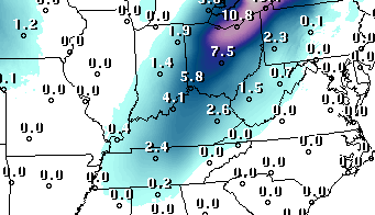
Meanwhile, we’ll be on the back side of this big snow-maker. The computer forecast models are predicting about a 2″ – 4″ snow in about a 100 mile wide swath from southern Indiana and extreme northern KY northeastward toward Lake Erie. That swath could reach 6″ or more over east-central IN and northwestern Ohio. The Louisville National Weather Service’s forecast includes Louisville in that 2″ – 4″ snow area. But, don’t count on that much snow here. I have two good reasons for predicting why our Louisville snowfall total should be lower.
First, the western side of Northern Hemispheric storms is a weaker precipitation-maker than the warmer eastern side. The northwest side of these systems has to “wrap around” moisture from the active eastern side of the storm. That’s a hard job to pull off. Nevertheless, it does work. Whatever moisture that does make the wrap around is rather small, but efficient. As it reaches the northwest quadrant of the storm, it encounters colder air which squeezes out some moisture. Little, if any, moisture can get far enough around to reach the southwestern quadrant of the storm. The problem here is that the Louisville area will be in the Southwestern quadrant of the system by Midnight-2 A.M.
Second, several models are predicting a weak low pressure to form west of the primary storm center. This development is expected over east KY and West Virginia. When that happens this evening, it will interfere with the wrap around precipitation mechanism of the parent storm. So, we have another problem with the potential snowfall here.
With all that to consider, here’s my forecast: a light rain/snow mix will begin during the afternoon rush hour and quickly turn over to snow this evening. Periods of light snow will continue overnight changing to flurries by daybreak. Temperatures will remain in the 30″s all night, so roads should remain mostly wet with just a few slick spots.
How much snow?
Louisville area: !” to 2″ on grassy areas
South of Louisville: less than 1″
Southern Indiana: 2″ to 4″ north of the Ohio River. 4″+ over south-central counties northeast to the Ohio border.