Category Archives: forecast

Severe weather threat is diminishing

Fri, Feb 24, 2017  5:30 P.M.

Moisture is still iimited and models continue to pay far more attention to northeast IN and MI.  Cold front should pass through Jefferson County between 8:30 and 9:30 P.M.  Some strong gusty winds are likely with the front, but winds should NOT reach the 58 mph range (needed to be called “Severe”).

Severe Storms Possible Tonight

Friday, Feb.24, 2017 Noon

A strong storm forming between St. Louis and Chicago will intensify rapidly during the day as it moves quickly northeast into Michigan.  North and west of the storm track heavy snow is likely.  However, the “warm sector” south and east of the storm will remain dry most of the day as we wait for a supply of moisture to arrive from the south.  Once the moisture gets north,  the strong dynamics of the parent storm should have no problem producing some severe thunderstorms.  Primary threat will be strong winds.  Hail is a slight risk while tornado chance is pretty close to zero.

This system is similar to the last time severe weather was widely advertised, but failed to show up.  The problem is with the moisture.  The dynamics with the system are tremendous, but the thermodynamics are quite weak.  So, once again, the various models are relatively low on the “probability” of storm formation, but the so-called “conditional probability” for severe storms is high.  What that means in normal people-speak is that the overall chance for a thunderstorm hitting you is small (about 30%).  But IF a thunderstorm forms, there is a high chance it’ll reach severe levels (about 50%).    So, if you multiply the two numbers you get a roughly 15% chance for severe winds within 25 miles of your home tonight. Obviously, the chance at any single point (your home)  is much lower.

The models agree well on timing.  The arrival of the cold front trailing the surface storm and sufficient moisture to generate thunderstorms should be about the same time.  Best timing for Louisville looks like between 8 and 10 P.M.  While some storms should form west of Louisville earlier, this system shouldn’t get well organized until it gets east of I-65.  Areas east of Louisville have a greater chance for wind damage than we do.  Best chance looks like 9 P.M. until Midnight for areas east of I-65.

Caution

As always, you’ll be hearing a lot of hype about storm potential this afternoon/evening.  What you’ll be hearing will be “the worst case scenario.”  Luckily, nature rarely reaches our hyped up expectations.

Interrupted sleep?

Monday. Feb. 6, 2017

Yes, it appears that thunder and lightning will be visiting our area during the late night hours tonight.  Also, the Severe Storms Center has us in a “slight” risk area for severe thunderstorms tomorrow.  However no severe storms are expected with tonight’s rain/thunder/lightning.

The situation looks like this:  a weak upper air disturbance will float slowly over the Ohio Valley between (roughly) Midnight and Noon tomorrow.  This system is starting to pick up some  Gulf moisture and rain/thunderstorms are popping up over northern TX, AR, west TN and southern KY.  Rain should become widespread over our area after Midnight and finally end around midday.  Thunderstorms will be embedded in the rain shield with the best chance for thunder here about 5 A.M. to 10 A.M.  Overnight instability will be low and the upper air dynamics, while good for an April/May severe weather situation, are actually pretty low for a winter system.  As a result, I don’t expect any severe storms overnight or tomorrow morning.  The dynamics aloft will have a hard time overcoming the lower level thermodynamics.

Then, atmospheric conditions change tomorrow afternoon/evening.  The morning system will drag most of the deep layer of moisture northeast of us.  But, a cold front will be approaching from the northwest.  The dynamics with this coupled surface/upper air system are expected to be much stronger than the overnight system.  However, most of the moisture will have disappeared.  So, the chances for thunderstorms to form along this front are quite small – about 10-20%.  But, if thunderstorms do manage to form, strong gusty winds and hail will be likely.  So, severe storms are possible late tomorrow afternoon , but the chances we’ll have any in the area are less than 10%.  Not much to worry about.  (But a few flurries will be possible early Wednesday.)

February

A couple of weeks ago, a major change in the upper air pattern looked like a good possibility for North America for this month.  The models were leaning toward temperatures being below normal for much of this month.  That trend lasted several days, but since then has shifted back to the primary pattern it has shown much of the winter – cold and wet over the western states and warm and wet over the east.  It looks well locked in, so not much hope for snow lovers.  Bad winter in that regard.

Super Bowl

It was amazing to watch New England turn the tide and rally last night.  You’ve got to give Tom Brady and the Pats credit for putting themselves to win the game, but to my mind, they NEVER should have won the game.  Atlanta just outright “gave” the game away.  With time running out, Atlanta had a second down with the ball in easy field goal range AND an 8 point lead.  Keep the ball where it was.   Run down the clock with a couple of runs – kick the field goal – game over – Super Bowl winners!  But, wait!  Somebody (I assume it was the offensive coordinator) calls a pass play that requires a deep dropback  by the quarterback.  Play starts, qb drops back and gets sacked.  13 yards lost – no longer in field goal range – Patriots get the ball back with a chance to tie the game.  And, they did –  then made it look easy in overtime.

Whoever called that play must have thought he’d catch New England off guard.  Seattle thought the same thing two years ago.  Look where it got them.

Stuff

The popcorn you buy at a movie theater costs more per pound than a filet mignon.

Another small snow

Saturday, January 28, 2017  3:30 P.M.

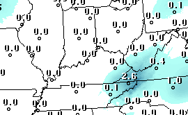
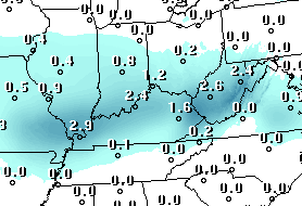
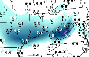
In similar fashion to our previous snow this month, the GFS and NAM are breaking tomorrow’s snow chances into two distinct segments.  With the latest NAM data, the only significant difference between the two models is with timing.  The NAM is a little faster, a common difference between the two.

Here’s how it looks now:  light snow should begin around daybreak in Louisville (earlier south of the city).  This will fade away by late morning, leaving only small amounts for the Louisville area. Maybe half an inch here, but a generous inch is possible over southern KY.  By late afternoon, a strong upper air system will plunge over the region and produce another period of light snow.  The morning system will take most of the available moisture away as it moves east.  Daytime heating will melt most of the morning snow before the afternoon snow arrives.

When the second snow ends by early evening, there probably won’t be much to show for the day’s efforts.  About .5″ locally, but 1″-3″ possible along and east of I-75.

Note:

Yesterday’s average temperature was exactly “normal” and today we’re back to above normal temperatures.  In fact, we haven’t had a below normal day here in almost three weeks.  January 9th was the most recent colder-than-normal day here.

Stuff

“young Americans” won the Academy Award for Best Documentary of 1968 during the 1969 awards ceremony in 1969.  Later it was discovered had been show in a theater in October 1967, making it ineligible for the 1968 award.  The Oscar was revoked, the only time that has happened in Oscar history.


Friday flurries!

Friday, January 27, 2017  4 P.M.

A weak upper air disturbance this morning brought us some flurries and a second one will bring us some more flurries for the evening rush hour.  With temperatures safely above the 32-degree mark, no problems are expected.

Cold weather should remain through the weekend with additional weak disturbances bringing additional periods of flurries.  Finally, a much stronger upper air system will cross the area Sunday afternoon and evening.  This is expected to upgrade the flurries to  a period of light snow and/or snow showers.  This morning the GFS and NAM were far apart on their portrayals of what the result will look like, but now the NAM upping its game toward the GFS solution.  But, don’t get too excited – even the “stronger” GFS still keeps snow expectations below one inch.

The current outlook for Sunday calls for some light snow/snow showers between (roughly) 3 P.M. and 8 P.M.  This should not have much of an effect on surface roadways, but bridges/overpasses/etc. could get some slick spots.  Snow accumulation should be light – anywhere from a dusting up to an inch.  For Louisville, about a half inch seems likely.

Bummer

My post earlier this week has already proven me right and wrong.  My long time conviction that long range prediction is  a fool’s game has been proven yet again.  But, my insistence to try it anyway is where I went wrong (probably).  My idea that the cold air arriving this weekend would hold through next week will not happen – unseasonably mild weather will return for next week.  Further, I said that some really cold weather should arrive around Super Bowl time – that part will probably hold, although it’s not looking quite as cold.  The worst part of my “outlook” was that the below normal trend should continue through most of February.  Sadly, that appears to no longer the case.

Moral of the story:  I should follow my own advice!

Still hope for some “winter” weather

Sunday, January 22, 2017

It’s been well advertised for the past  ten days or so – an upper level pattern change that was due to begin late this week.  That would shift the major storm activity from the Pacific coast into the eastern U.S., setting up the winter-weather favoring “East Coast trough – West Coast ridge” pattern that would open eastern North America to renewed outbreaks of arctic air.  We haven’t seen this pattern much this winter.  It set up for about 2-3 weeks during December and then again briefly in early January.  Each time, it could not establish a foothold and returned blasting the western U.S. with heavy rain and snow.  That has been good for California, as the years-long drought has been wiped out (for now).

As usually happens when forecasters try to look out a week or two in advance,  the expectations don’t meet the reality when it finally arrives.  That seems to be happening this time as well.  Colder weather appears likely by late week and the weekend.  But, current forecasts for temperatures are running 5-10 degrees warmer than they were a few days ago.  So, it looks as though the first attempt to establish the east coast trough will only drop us into the “near normal” range rather than the previous “below normal” expectations.

But, snow lovers,  there is some good news.  The GFS and the European model continue to deepen (strengthen) the troughing over the eastern U.S. so that Super Bowl weekend should see the beginning of some strong cold air outbreaks ( and maybe some snow(s)).

Although I have repeatedly stated that long range forecasts can be highly unreliable, I will take a stab at what happens after that.  The U.S. has a forecast model known as the Climate Forecast System (CFS) designed to project the months ahead in general terms.  Since I usually concern myself with current weather and a few days ahead,  I’ve never paid much attention to the CFS.   But, if you want to dream big, the CFS is predicting that once the east coast trough really establishes itself (11-14 days from now), it will hold until the end of February!  That could make for a lot of fun next month

(And that could be our last chance as the CFS expects March to return to above normal temperatures.)

Current weather

I seems pretty obvious by now that those forecasts for heavy rains (Thunderstorms?) and possible flooding (especially south of Louisville) are not going to materialize tonight and tomorrow. We’ll probably see some rain tonight, mostly after midnight.  Total should be a quarter-inch or less.  After that, the next few days should be dry with continued mild temperatures.

Stuff

If you were asked,” How many Presidents has Kentucky produced?”, the obvious answer would be “one.”  But, some people count Jefferson Davis as a second President.  That’s a “trick answer” as he was President of the CSA not the USA.  But, in a little-known historical quirk, Abraham Lincoln was actually the second Kentuckian to serve as President of the USA.  Here’s the story from the very interesting website, www.mentalfloss.com. …

In 1849, Zachary Taylor refused to be sworn in on a Sunday, because he was very strict about “keeping holy the Sabbath.” The position of president couldn’t just be vacant until Monday, so the President Pro Tempore of the Senate, David Rice Atchison, was brought in as a pinch hitter. There’s some debate as to whether this actually makes him the 12th president and Zachary Taylor the 13th, but obviously, it’s generally accepted that he doesn’t count. He didn’t even stake claim to the title, and repeatedly told people that he slept through most of his day as president. He must have had a good sense of humor about the whole thing, though, as evidenced by the inscription on his gravestone.


Snow update 2

10 P.M. Wed. Jan 4, 2017

Couple of updates…

1).  Models continue to run faster.  Snow should begin 7-9 A.M.  and taper off by early afternoon.  A SECOND period of snow should occur during evening rush hour.  Morning snow should amount to roughly one inch.  Second snow may reach .5″

2).  Most recent model runs have become “drier”, probably because of faster movement and the distinct two-phase nature of the snow system(s).

3). Road conditions described on earlier post still look good.

4).  Still looks like the heaviest snowfalls (combined from two snow periods)   will be east and south of Louisville.  Areas east of I-75 could reach 4″-5″.

Update on snow forecast

Wednesday, Jan.4, 2017

After a further analysis of the morning data and with looks at the short-range models, the outlook for tomorrow’s expected snowfall has become more narrowly focused.  Some adjustments seem necessary to me.  So here’re my latest thoughts.

1). Timing

Most models are speeding up the timing on the snowfall.  Light snow now looks like it’ll start during rush hour, probably around 8-9 A.M.  It should be light enough that only a few problems with the roads will occur during the morning rush.  Heaviest snow should fall between 10 A.M to 1 P.M., then diminish before the evening rush hour.  Treated roads should be in good shape for the evening commute while untreated roads are likely to be an icy mess.

NOTE:  A couple of models are developing a secondary system (behind the main snow-maker) that could create another round of light snow/flurries tomorrow evening (7-9 P.M.).  If it develops, little, if any, accumulation should result.  Probably just a dusting, or so.

2). Amounts

Tough call.  With the very cold air, snow tends to “fluff” quite a bit.  So,   a little bit of water can add up to a lot of snow.  On the other hand, with the majority of the snow falling during the day, it tends not to accumulate as much on the roadways.  With those ideas in mind, it should seem almost as though we’ll see two different snowfalls – one on the grassy areas and another on the roads.

First, the grassy areas – the Louisville area is in line for 1″ – 2″ of snow.  Parts of southern Indiana, especially west of I-65, could see a very fluffy 3″-4″.  The most recent model runs are showing a stronger emphasis for snow south of Louisville.  Looks like the southern half of KY may end with the highest totals, especially south of I-64 and east of I-65.  I wouldn’t be surprised to see E-town, Bowling Green, Lexington and London reach 3″-5″ of snow by tomorrow night.

Second, the roads.  In the Louisville area the treated roads should be easily passable throughout the snow.  With brine today and salt tomorrow, there shouldn’t be many problems.  However, the untreated roads will offer plenty of thrills for area drivers.  Snow accumulations on the untreated roads will average around one inch – plenty of snow/ice to produce numerous fender benders.

Outside of the Louisville area, travel should be pretty slow on most roads, especially the untreated ones.

Another attempt at a pattern change.

Monday, November 20, 2016

Two weeks ago I wrote about the upper atmosphere’s attempting to evolve into a different, colder, weather pattern.  It tried, as several weak systems attempted to bring in colder air.  However, the upper air winds were unable to generate the anticipated west coast ridge- east coast trough.  As tv’s Colbert would say, we got some east coast “troughiness”, but not the real thing.

So, two weeks later we find a pattern that still contains a strong upper trough from the Gulf of Alaska southward.  New to the scene has been the development of weak troughing over the northeastern U.S.  The upper ridge over the southeast U.S. has moved westward and weakened quite a bit.  It’s now centered as a very flat ridge over the western Gulf and Texas.

So, what was expected has happened, but to a much smaller degree than anticipated.  Now the atmospheric jet stream over North America has been left in an unusual pattern – too little spacing between the two troughs.  That sets up an unstable situation  which will result in much more weather activity over the next two weeks.  We’ll see a big increase in storms and weather changes as energy pockets swing around the big west coast trough, rapidly swing across the U.S. and hook up with the weak east coast trough.

This situation looks to have two possible solutions – 1).  The increased atmospheric instability shifts enough energy from the western trough to the eastern trough to allow it to become the dominant system. That results in a colder than normal eastern U.S. for December (and probably most of the winter.  Or, 2).  The western trough remains dominant and the eastern one never really establishes much strength.  That would mean a wet, mild December.

So, which scenario is more likely?  Today, both the GFS and European models are favoring scenario number 1.  If it works out this way, we could have a very interesting December, weather-wise!

Stuff

Grey Poupon wasn’t given its name because of the color of the mustard. The moniker actually comes from the names of two 18th century mustard firms from Dijon, run by Maurice Grey and Antoine Poupon.


Pattern change ahead.

Monday, November 7, 2016

Another weak cold front will pass through the area tomorrow evening.  And, the expected weather will be very similar to last week’s light rain.  The front and the upper energy will be arriving from the northwest and will not have much moisture with which to work.  So, same idea as last week – a pretty high probability for a little bit of rain.  For those who received some rain last week (unfortunately not my yard),  it’ll be about the same again – a trace up to about .10″ of water.  So, the dry conditions will continue.

Changes ahead

For most of this fall, our warm, dry weather pattern has been caused by a strong upper level ridging pattern (upper air high pressure) pushing the primary jet stream far to our north over Canada.  The ridging pattern has been dominate, but has weakened at times to allow some weak cold air masses to invade the eastern U.S.  But the ridge has always rebuilt quickly to bring back the above normal temperatures.  That’s been the basic upper air pattern since late August with the predictable result of a warm, dry autumn.

Last week, however, the global forecast models started pointing toward a breakdown of that system.  In general, the upper air ridge sitting over the central U.S. is expected to retrograde (shift westward) to the southwestern U.S./eastern north Pacific.  This will open the door for an upper level trough (upper low) to dig into the eastern half of North America.  This will not happen quickly.  It is starting now and will bring us some Canadian air by Wednesday, then a second burst of energy will bring us even colder air by the weekend.  Then, a third system will bring even colder air early next week.

How long this trend will continue is an open question.  Yesterday, the GFS brought a massive storm into the Ohio Valley (with snow!) on the Tuesday before Thanksgiving.  Today, it has forgotten all about that storm idea, at least for the Ohio Valley.  Meanwhile, the European model is generally a little colder than the GFS with the upcoming colder trend AND it still is hinting at a major pre-Thanksgiving storm over the Ohio Valley or the southeastern states.  It’s still far to early to do any serious speculation on any storms.  But, it does appear very likely that we’e going to drop into the “below normal” temperature category for the next 10 days to two weeks.

Election Day

Ever wonder why our Federal elections are held on a Tuesday?  If your answer is “no”, stop reading and be sure to VOTE tomorrow.

If, however, your answer is “yes”, continue reading.  Back in the early days (late 1700’s and early 1800’s) there were no national laws governing elections.  States could chose to hold them whenever they wanted…as long as they had their votes counted before an early December meeting of the members of the Electoral College in Washington.  That worked pretty well until the number of states starting growing larger.  In the 1810’s Congress tried to organize some of the randomness by mandating that the state elections had to be held within a 34-day period of the fall.  By the 1840’s, as communication methods improved, the varying dates of state’s elections started to play a role with the later-voting states’s voting patterns, or so it was believed.

So Congress agreed that everyone should vote on the same day.  But how to chose the day?  Back then, the country was mostly agrarian, so it should be a time after the crops were harvested.  But, the winter had frequent snow storms (remember, most of the U.S was in the northeast back then), so the winter months were too risky.  That left November as the logical choice.  But which day of the week?   Sunday was out because it was church day and a day of rest.  Monday was out because of Sunday.  Back in the horse and buggy days, many voters would have to travel the day before (Sunday) so they’d have the time to vote and get home on Monday.  So, Monday lost out due to possible Sunday travel (not a good idea in those times).  Wednesday was Market Day – when the farmers brought their goods to town to sell to the city-dwellers.  To Congress, the logical winner was Tuesday.  In 1845 the matter was settled by Federal Law – Election Day would be on  the Tuesday immediately following the first Monday in November.

That’s tomorrow…please VOTE.