Category Archives: stuff

Snow still looks likely for Sunday

Saturday, February 14, 2016

Today’s GFS and NAM have become pretty close to each other with regard to the light snow storm expected tomorrow.  And, they both continue the faster approach of the snow.  As it looks now, snow should begin tomorrow morning.  Arrival time should be between 10 A.M. and NOON.  Snow should continue through the afternoon, then diminish during the evening.  Accumulation around the Louisville area should run in the 1″ – 2″ range.  Higher snow totals are likely over most of Kentucky south of Louisville.  Plus, another Gulf coastal storm forming early Monday could add additional snow for the southern half of the commonwealth.  That storm should not effect southern Indiana or northern KY.

So, by midday Monday, accumulations of snow could reach the 4″-8″ range over southern KY while the Louisville area remains in the 1″ – 2″ range (or lower by then).  Temperatures Monday should jump into the 40’s, so any snow we get won’t last long.

Looking ahead…yet another Clipper appears on the horizon for Tuesday.  Current indications are that the surface reflection of the system will move north of Kentucky.  That puts us in the zone where not much happens.  After that temperatures should begin a major upward trend – could even reach the 60’s by next Friday.

Stuff

Monday we’ll celebrate Presidents Day.  However, there really is no “official” day to celebrate our Presidents.  The official name is still Washington’s Birthday.  But, after the 1971 act to make the three-day weekends, people have just been calling it Presidents Day.  But, it’s not!

Weekend weather outlook

Friday, February 12, 2016

Another blast of cold air is pushing across the Ohio Valley setting the stage for a very cold weekend. The new surge of cold air should bring along  some snow flurries, but just a dusting of snow is likely.  High temperatures tomorrow will only reach 20-22 but Sunday should warm to around 30.  But, the big question is whether all that cold air will be setting the table for some snow.

Yesterday, I discussed the upper level “wave train”  that would the big feature in our weather for the next few days.  (Additional details in yesterday’s post)  Wave 1 passed over the area this morning with the expected results.  Wave 2 still looks on target to the discussion yesterday…with one exception.  It now looks as though the timing of the system will be about 6-12 hours earlier thought.

So, Sunday’s outlook now looks like this:  Thickening clouds during the day with light snow beginning by late afternoon.  Periods of light snow continue overnight but ending before daybreak.  This remains a rather disorganized storm system.  Snow forecast remains in the 1″ to 2″ for the Louisville area with perhaps a little more over southern Kentucky.

Biggest changes to forecast are with the “last wave on the train.”  As mentioned yesterday, the last energy pulse is (almost) always the strongest.  Today’s models have emphasized that idea by making wave 3 even deeper that yesterday.  If this trend holds up, what once looked like a good chance for a sizable snowstorm now looks as though it’ll probably miss us entirely.  Now appears that the storm will organize over the Gulf states then head up the Appalachians as another major snow-maker for the eastern states.

As things stand now, the Washington’s Birthday holiday will be cloudy and cold with snow flurries possible – a far cry from what the models have been indicating for the past week.  Oh, well.  There’s still time for change.

Stuff

Valentine’s Day derives from an ancient Roman festival named Lupercalia.  The February 13-15th festival was a fertility rite believed to be in honor of the god of agriculture.

Super Sunday

Sunday, 2/7/2016

Super Sunday turns out to have a double meaning for us…great weather plus the Super Bowl this evening.

First, the weather.  Enjoy today because winter will be rushing back in by tomorrow.  The commonly called “Polar Vortex”  is once again pushing south into eastern North America.  A sharp cold front will arrive tonight and replace the current seasonably warm  conditions with an Arctic blast.  Since the system’s origins precludes any significant amount of moisture, the cold air will only be accompanied by snow flurries and snow showers.  Timing makes a great difference in events like this. Day vs. night makes a big difference.  I discussed this in a Jan.14, 2016 blog…Observations from this week’s snows.  Check it out.

Here’s how the current situation is shaping up… cold air arrives late tonight along with a 30%  chance for rain showers.  It’ll take several hours, probably between 8-10 A.M., for the air to become cold enough to support snow rather than rain showers.  Periods of light snow likely during the afternoon with up to a half-inch on grassy areas.  Roads remain wet, but possibly a few slick spots on bridges and overpasses toward evening.

Monday night looks like the best  chance for accumulating snow from this system.  Cold air will be firmly entrenched, still some residual moisture will be around and an upper air pocket of energy looks as though it’ll fly overhead.  The result should be some light snow and some snow showers.  Most of us should see .5″ to 1.5″ by Tuesday morning. Some areas will probably see some heavier snow showers putting down as much as 2″-3″, but they should be pretty scattered.

By Tuesday, we’ll still have plenty of cold air (20’s for highs),  but there won’t be much moisture or upper support left.  So, snow flurries will continue, but little (or no) accumulation is expected.

Although this won’t be much of a snowstorm, there’s still the potential for some major road problems from early Tuesday through Tuesday morning.

Super Bowl

I’ve only attended one professional football regular season game in my life.  It was at Mile High Stadium back in the late 1960’s and featured Denver winning over the Buffalo Bills. I think the score was 17-14. I’ve had a warm spot for the Broncos in my hearts ever since.  But, trying to look objectively at today’s game, I think the Denver Super Bowl mystique will continue.  Denver has been in seven Super Bowls but has won only two.  The average winning margin of those games has been over 20 points.  All but one game have been blowouts, The Broncos have been on the losing end of a blowout five times.  Today looks like it’ll be #6.  (Sorry, Broncs and my sympathies go to Kent Taylor…a HUGE Broncos fan!)

Joaquim hits the headlines

Wednesday 30, 2015

Usually, I keep my weather thoughts local, but hurricanes seem to catch people’s eyes no matter where they are.  So, some  things I find interesting about what I’ve seen concerning Hurricane Joaquim today.

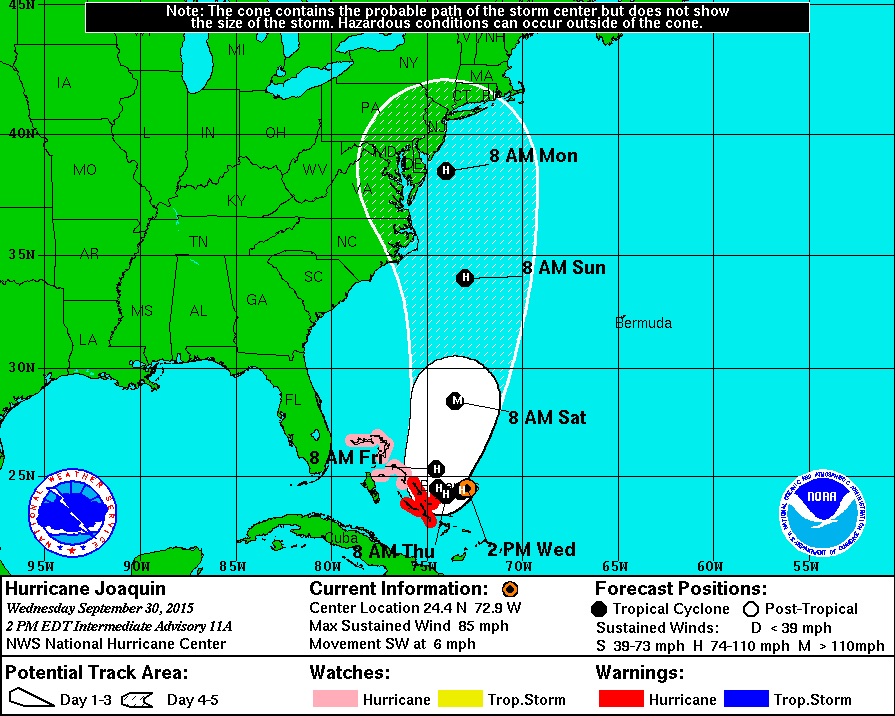
First, the National Hurricane Center’s current forecast path chart (below) hugs the east coast from the Carolinas all the way to eastern Canada.  However, no model I’ve looked at shows anything like that.  I know the projection is a composite, but it’s not really telling us anything.  (Actually, it’s probably intended that way.  CYA as the saying goes.)

Also, the chart’s timing doesn’t seem to follow much of the guidance, either.

joaquim path

Now, let’s try to really do some forecasting of Joaquim.  First we have two “outlyers” in the models.  The European takes the storm far off the east coast with the only problem being a pass near Bermuda, but probably only as a fading tropical storm.  The NAM basically keeps it stationary for a couple of days, then rips it apart as it begins to move (upper shear increases).  But this still leaves the possible of same very heavy rains along the east coast over the weekend into early next week.

Now, the GFS models, joined by the Canadian and Navy models) point toward a far different solution – one that makes a lot of sense to me.  But it does lie outside of the “official” guidance envelope.

Nevertheless, here’s what the models say to me at this time.  The weak upper air disturbance which has brought the very much needed rains to us the past two days has basically “cut off” for the main upper level flow and will drift slowly southward for next couple of days – basically a small pool of cold air aloft to keep weather unstable over the areas south and east of the Ohio River.  By late week, another pocket of cold air aloft with arrive to strengthen the “cutoff” and push it a little eastward – just far enough to absorb the circulation of Joaquim and drag it westward into the southeast coast.  When the cutoff low absorbs we start developing the major transition of Joaquim from a hurricane (or tropical storm) into what’s now called an extratropical low  (Years ago the NHC started calling these rare hybred systems “neutercanes” but the name never caught on.)

In  laymen’s terms what that means is mid latitude low pressure dynamics coupled with tropical moisture.  The usual result is not much of a wind problem, but PLENTY of rain and flooding problems.

Assuming the above process happens, here’s what I expect – Tropical Storm (or small hurricane) Joaquim will hit Saturday night along the Carolina Coast – probably between Myrtle Beach and the Outer Banks.  The decaying storm will then drift around the Carolinas for up to 48 hours causing massive rains and major flooding.  Heavy rains will also move up the east coast Sunday, Monday and Tuesday.

Update tomorrow!

Note:

So far  this year eight people have been killed by sharks.  And, 12 people have been killed while taking “selfies.”    Message:  Beware the selfie!


Soggy weather continues

Friday afternoon (Mar 13)

It’s been a week with two very nice early spring days, but also with some very wet days as well.  The second major rain system of the week is over us now and looks like it’ll hang around until at least midday tomorrow.

One reason for the warm wet weather has been the absence of the northern (Polar) jet stream.  It has receded far north of us this week allowing weak subtropical weather disturbances to drift slowly into the Ohio Valley.  This one is more widespread and slower moving than the one earlier this week, so another large dose of rain is likely.  Our area could easily see 2″+ plus of rain before it fades away tomorrow afternoon.  So, once again, we’ll see renewed urban flooding and the larger rivers and streams will (perhaps) see a second crest this weekend and an extension of time remaining above flood stage.

The northern jet is about to reenter the weather situation this weekend.  It’s influence on us will start slowly tomorrow when it sends a batch of cooler, drier air to end the current rainy weather pattern.  The jet will ease a bit early in the week (pleasant Sun, Mon and Tue), but will send us a colder air mass by mid week and an even colder one by next weekend.  Yes, winter’s not over.

NWS Radar rain estimates.

I’ve long been amazed at how well the “rainfall total” estimates from the National Weather Service’s radar match up with the so-called “ground truth” –  the totals measured by surface rain gauges.  I was amazed again Monday, but for a completely different reason.  This time the radar estimates over the whole range of the radar were all BELOW one inch (.6″ to .99″ range).  However, the rain gauges at the airport and Bowman Field both recorded about 1.5″.  So, actual measured values were more than 50% higher than radar estimates!  Something is waaaay off.  I don’t know why, but I do have a theory.  The algorithm  currently being used by the radar is probably designed for winter weather.  In the winter, in rain/snow situations, radar will often display an area of high reflectivity.  That looks like an area of heavy precipitation.  In reality, what it is usually “seeing” is a region where snowflakes are melting as they fall toward the ground.  Thus, you have snowflakes surrounded by liquid water.  The radar interprets that as huge raindrops – thus assuming heavy rain which creates an artificially intense radar return.  The common term for this is bright banding.  So, the winter radar algorithm makes allowances for this bright banding and reduces the “radar detected precipitation” accordingly.

However,  in a warmer situation when the freezing level is far above us (like the two rain situations this week), radar echoes displaying the same levels of intensity as winter “bright banding” are, in fact, measuring just what they seem to be – heavy rain.  Thus, using winter schemes during a spring rain will greatly reduce the “radar detected rainfall.”

Now, this seems like a problem with an easy fix – change to the correct algorithm.  Evidently, however, my theory must not be correct.  Because it’s happening again today!  As of 5 P.M., radar rain fall estimates for an area roughly 40 miles around Louisville showed about 75% of the area rain totals below .30″ while the other 25% have had between .30″ and .59″.  Meanwhile, SDF and Bowman Field (LOU) rain gauges were reporting between .70″ and .80″ of rain so far.  But then, what’s that old line – Fool me once, your fault.  Fool me twice, my fault.?

Very unusual Pi Day tomorrow.

Within the past two decades or so, math and science oriented people have thought that the very important math symbol “pi” should get some credit.  pi’s value is 3.14…, so March 14 or 3/14 is celebrated annually as “Pi Day.”  But, tomorrow is an extra special version of the day – it will not be repeated for a 100 years!  Going out a few more numbers in the value of pi we get 3.1415…  3/14/15 is tomorrow’s date.  Then the next three numbers of pi are 926.  So, tomorrow at 9:26 A.M. and 9:26 P.M. we’ll have the following number string – 3/14/15 9:26  The most digits of pi you’ll ever see on Pi Day (unless you live a very long time).  And, if you want to go to seconds, the next two numbers are 53.


    Now, that seems to be a problem with an easy fix – change to the correct algorithm.  Evidently, however, my theory may not be correct.  Because it’s happening again today!  As of 5 P.M., Radar estimates within 40 miles (or so) of Louisville showed about 75% of the area with rain less than .30″  and the rest of the area in the .3″ to .60″.  However, both airport rain gauges in Jefferson Co.  were reporting totals between .7″ and .8″.


Cold night ahead.

Thursday Afternoon (Mar 5)

“Oh, what a beautiful morning; oh, what a beautiful day.”   (from “Oklahoma”)

Just about the only thing that makes me feel better after such a poor forecast is the ability to really enjoy what nature has provided for us.  Those of you who take a more negative view of snow, don’t worry.  March sunshine can eat up snow in a big hurry.

So, now the weather attention turns to the cold air/snow cover combination which can sometimes lead to some extremely cold temperatures.  In a similar situation to a few weeks ago, the NWS is predicting some really cold readings for tomorrow morning (-5 to -10).  Forecast model guidance is once again significantly warmer than the forecast ( 13,10 and 4 deg) are their most recent forecasts.  True, conditions look good, but this air mass is not as cold as that one was.  If skies clear for most of the night, as is expected , near zero lows are likely, but -10 appears unlikely except in some rural areas.  I’ll stick with a low of 3.

If skies clear this evening…

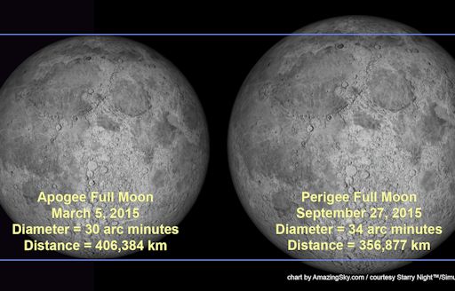
Tonight is the night of the mini moon.  Each year we hear of the giant or super moon when the Earth-Moon distance is the smallest of the year.  But, if there is a Super Moon, there must be an opposite full moon when the Earth-Moon distance is the greatest.  That’s called the mini Moon – when the full moon is smaller and dimmer than any other full moon of the year.  Tonight’s the night.  Look east around sunset if the clouds are gone.  See if you can tell the difference from other full moons.

minimoon_strip

image from Alan Dyer of Silver City NM

Colder again tomorrow and Friday

Wednesday Afternoon

As it turned out, it wasn’t too difficult to get temperatures above 40.  Unfortunately the milder weather won’t last long.  A moisture-starved upper air disturbance has been passing over the Ohio Valley this afternoon.  All it could do moisture-wise was the clouds this afternoon.  They will fade away tonight.  But this system is also bringing us another shot of unseasonably cold air.  It won’t be as bad as Monday and yesterday, but should hold highs to the mid 30’s tomorrow and near 40 Friday.

It still looks like some rainy (and warmer) weather will arrive by the weekend.  A strong storm is taking shape over the southwestern U.S. and will provide us with at least 3 “waves” of energy before it exits our area.  First, the leading edge of this system will send a weak disturbance our way Saturday.  As often happens, the first surge of energy brings lots of moisture into the area but little, if any, precipitation.  This one looks the same way and if it does produce any rain it will be more likely over southern Indiana rather than Kentucky.  A lot more energy will be tied up in the second system, set to arrive Sunday.  This should bring lots of rain and temperatures rising to near 60 degrees.  Even a thunderstorm will be possible.  A third storm should arrive on Monday.  It’ll prevent any major temperature drop following system 2, but it should bring us some more rain.  Following that system, we’ll see temperatures dropping back to January levels (highs near 40) for a couple of days.

Polar Bear Stuff

Over the past few days, several world newspapers have been carrying stories about a “40% population decline in the past 10 years.”  Brings back Al Gore’s photoshopped picture  of a lonely polar sitting on a small chunk of sea ice with nothing but water anywhere to be seen.  It was the major talking point for his infamous declaration that polar bears would soon disappear because the Arctic would have ice-free summers by 2013 or 12014.  (This summer’s ice cover minimum was 4.9 million square kilometers  Current ice cover is 9.9 sq. km.)

Dr. Susan Crockford is a Canadian zoologist and professor who has been studying polar bears in the Canadian and Alaskan Arctic for more than three decades.  She says the actual data is a whole lot different than the article claims.  Yes, there was a drop in bear population between 2004 and 2006.  Estimated drop was 25-30% of the population.  The time corresponded to a series of years with thicker than normal sea ice in the spring.  (Yes, a colder time.)  Then spring sea ice diminished though about 2012 .  What happened to the bears?  Their population grew back to pre-2004 levels and is thought to be still growing.

Yes, that’s just the opposite of what the so-called greens have been shouting to us for almost a decade.  Just goes to show you what happens when non-scientists start preaching about science!  We could have saved a lot of time and effort if we’d just believed the real experts – the Inuits.  Old saying among the Arctic dwellers- Warming weather brings more polar bears!

Snow!!!

Sunday Afternoon

Forecast models have changed little since yesterday – the NAM is still a little warmer than the GFS.  Short term models (RUC, NAM-hi res and others) fall in between, but tend to be closer to the GFS.  The big question remains – how soon will the rain change to snow?  Obviously for snow lovers, the sooner the change, the better.  I am expecting the change-over to occur in Louisville between 7 and 8P.M.  (earlier in southern IN; later south/east of town.  Snow should be wrapping up by 7 to 8 A.M. tomorrow.

Based on the timing above here is my current forecast (5 P.M.)…Louisville metro area should see an accumulation of heavy wet snow between 3″ and 5″ (on grassy areas, less on the roads).  Southern Indiana should see an accumulation of 4″ to 6″ with KY counties and southern counties along and north of the Ohio River from Louisville toward Cincinnati could receive 6″+.  South of the Louisville area, accumulations should diminish rather quickly.  The E’town area should see 1″-2″ with very little at Bowling Green.  East of Louisville, snow totals should also be lower.  For example, Lexington should get around 1″ to 2″.

As mentioned the past few days, this will be a very wet snow as temperatures hovering a degree or two above/below 32 deg.F.  As the snow will be falling at night, it should have little trouble piling up on grassy areas.  However, the roads are still pretty warm.  That plus traffic should greatly reduce accumulations on the roadways.  The roads will probably only get half as much accumulation as the grassy areas.

snow1      snow2

Stuff

There’s no such thing as bad weather…only varying degrees of good weather.

Snow situation keeps changing

Friday afternoon

Each day our two primary forecast models get a little closer together on the prediction for snow (or rain) Sunday night…and there’s still a lot that could change over the next 48 hours!

With today’s model runs, the NAM has joined the GFS with the primary precipitation event expected Sunday night into Monday morning.  In fact, the expected preliminary event Saturday night night now looks to be a bust…nothing more than a dusting appears to be the best case scenario now.

If nothing else, the Saturday night system should serve to moisten our very dry atmosphere so that Sunday night’s system should have no problem with moisture supply.  That said, what kind of moisture should we expect?  The NAM model has warmed since yesterday.  If it proves to be correct, the majority of the upcoming storm will probably be rain with a late night change to snow.  That would keep snow accumulations low – probably around an inch.  On the other hand, the GFS keeps us firmly in the colder air.  Possibly a little rain to start, but snow after that.  This, of course, favors a larger accumulation – it still looks as though we have the potential for a 2″ to 4″ snowfall!  Temperatures should be right around 32 degrees (plus or minus a degree or two) so it’ll be a sloppy wet snow (good for snowballs and snowmen).  Accumulations will be highest on grassy areas,  but (since it’ll be mostly at night) roadways will get their share too.

As to which model is going to be right (or, at least, the closest to right), I don’t know.  Years of experience of working with both models has given me this generalization – from 0 to 36 hours the NAM is usually equal to (or better than) the GFS.  Beyond 36 hours, the GFS is almost always better then the NAM.  So snow lovers, the situation looks good for Sunday night…but a lot can happen in 48 hours.  Stay Tuned!

Stuff

Yesterday, I showed pictures of a full 180 degree rainbow (my first ever) taken near Vigo Spain.  That brought to mind a picture I had seem of a full 360 degree rainbow – you can see them from the air above.  Here’s one from Perth Australia.

fullrainbow_leonhardt_1500

Fun Fact:  Damascus Syria is the  believed to be the oldest permanently inhabited city on Earth.  Evidence dates back to a settlement as long ago as 8,000 to 10,000 years B.C.

Stuff

Later Thursday afternoon

While on hiatus, my wife and I did some traveling.  We were in the Spanish coastal village near the city of Vigo one sunny morning (our tour guide had made fun of the local forecasters who had predicted some showers for the day).  We were exploring the grounds of an ancient fort that was now a luxury hotel.  While we were there, a few showers popped up (chalk one up for meteorologists) and produced, what to me, was the first end-to end complete rainbow I had ever seen.  It was too long to capture in one shot with my camera, but the pictures below show each end (you can fill in the rest mentally).  By the way, if you want to find that elusive “pot of gold” at the end of the rainbow, you’ll need some scuba gear!

066

067

Fun fact:

The city of Vigo, Spain, is where Columbus landed in early 1493 on his return to Europe after historic trip of 1942 to the “New World.”