11 P.M. update 2/14/2019
Latest model runs are leaning toward no snow for the Louisville area Friday night/early Saturday. Any accumulations will be south of Louisville.

11 P.M. update 2/14/2019
Latest model runs are leaning toward no snow for the Louisville area Friday night/early Saturday. Any accumulations will be south of Louisville.
Thursday, Feb. 14, 2019 4:30 P.M.
Snow possible tomorrow night!
Happy Valentines Day!
First of all – tonight. A weak cold front will cross the area. It has little upper air support and slim moisture available. Nevertheless, it could squeeze out a few, brief light showers tonight. Only about a 30% chance for a measurable amount. Temperatures tomorrow should stay near 40 during the day.
Snow situation
The northwest U.S. is being pounded by yet another winter storm. A small piece of upper air energy is breaking away from the parent system and will move eastward across the country over the next two days. Both the GFS and NAM portray this system a little stronger than yesterday. They still differ on the storm path and consequences for us.
The GFS is gung ho on snow for us as the surface system slides south of us tomorrow night. GFS snow totals are around 2″ for Louisville area with heavier totals (up to 4″) over SW Indiana and western Kentucky. Snow forecast is even higher along a path from near Evansville to south of St. Louis to Kansas City.
Then, there is the NAM. Like yesterday, it isn’t taking the snow very seriously for the Louisville area. It projects the storm track to be a little farther south. That puts us on the northern edge of the snow threat. Southern KY will see a mix of snow, sleet, freezing rain and rain creating major road problems tomorrow night and early Saturday. It also has the heavy snow from far western KY back into Missouri.
So, which model is correct?
Good question. Can you wait until Sunday morning for the answer? Of course not! We want to know beforehand. So, I’ll give you my thoughts on the situation.
In general, most of the forecasting fraternity will go with the GFS. Over the long haul, it seems to be the better of the two. But, this winter the GFS has had snow lovers salivating over two big snow forecasts. Both times local media and National Weather Service followed the GFS and went into hype mode only to have both forecasts fail. Overall, the GFS has been in a slump but the NWS is going along with its 2″ forecast for tomorrow night.
But, what about the NAM? It’s a good model, too. But the wide differences between the two models for this forecast must mean something. If tomorrow night’s weather solution were “settled science”, the two models would be very close. The fact that they are not close tells us there is something about this atmospheric setup that they can’t quite resolve. In essence, neither model can be ignored.
So, here’s my best shot. I’m leaning toward the NAM ideas having the surface storm taking a more southerly track. That means less snow for the Louisville area. I’m expecting less than one inch for Louisville metro. Snow totals will increase south of the city and could get an inch or two down to the E’town area. South of the parkway they’ll see the wintry mix described above.
West of Louisville snow accumulate along and south of I-64. The farther west in IN/KY, the more snow – as high as 4″ near Evansville. North of Louisville, little or no snow will fall.
Again, I believe the Louisville area will be on the northern edge of the snow system. I expect less than 1″…probably closer to the lower end of the range.
Valentines Day
For hundreds of years BCE (B.C.), the Romans celebrated a Spring ritual known as Lupercalia. It was a fertility rite to welcome back the growing season, among other things. It was celebrated around February 14th. About 500 CE (A.D.) the Catholic Church decided that Lupercalia was a little too bawdy for its flock, so it was banned. It was replaced by a new Church holiday they named Valentines Day in honor of an Italian saint who had been decapitated (by the Romans).
Wed., Feb. 13, 2019 5 P.M.
Two chances for wintry weather later this week
Big winds last night, but they couldn’t push in much cold air. Wind direction stayed from the SW to W last night and today, so not much cold air pushed southward. And as winds go back to SW tomorrow, a very quick warm up is due. Temperatures are expected to reach about 60 tomorrow.
Then, a weak cold front will pass by tomorrow night with a small (20%) chance for some rain showers after midnight. Then some colder air arrives for Friday. And with the colder air, the chance for some light snow returns as well.
Weekend snow?
Two weak upper air disturbances will arrive from the west coast. The first one arrives Friday night and (at this time) appears as though the southern half of KY could see an inch or two of snow by Saturday morning. We’ll be on the northern edge of this system and any snow we get would be less than an inch. NOTE: At this time, this system is very “iffy”. The description above is portrayed only by the GFS. The NAM pretty much ignores this system. So, I suspect we’ll be hearing changing forecasts in the next few days.
The second system is expected to be a little stronger. It arrives Saturday night and continues into Sunday. Temperatures are likely to remain above 32 during this event. The majority of the precipitation will be rain and/or drizzle. However, it may start briefly as some light snow. The GFS and NAM are in pretty close agreement with this system.
Ohio River
The Ohio’s still above flood stage and climbing slowly. Crest is still expected Friday at around 28′ to 28.5′. However, the river will fall slowly and will not drop below flood stage until next week.
Strange weather in Hawaii
A major storm rocked Hawaii Sunday and Monday. Some coastal waves were estimated to be as high as 60 feet! A wind gust of 191 miles per hour was recorded.
The Haleakala Observatory, which sits atop the 10,023 foot Haleakala Volcano on Maui, contains several of the worlds finest telescopes. They were frozen in place and covered with snow. The photo below is from Monday’s snow. More snow was expected Wed/Thu.
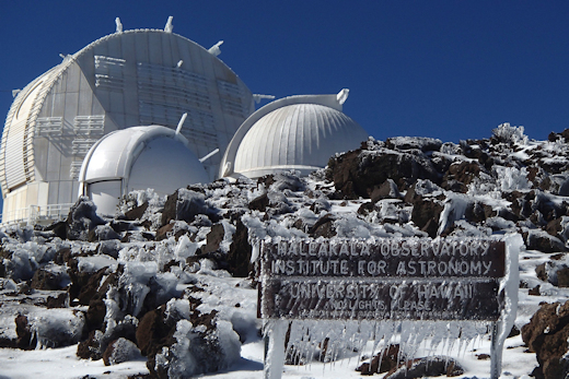
Photo from http://www.spaceweather.com
Sun. Feb. 10, 2019 3 P.M.
Periods of rain through early Tuesday
The Ohio: Predictions for the Ohio River in Louisville are little changed since yesterday. It’s expected to reach flood stage (23 feet) midday Tuesday and crest just under 30 feet Friday. Those forecasts take into account past rains plus expected rain for the next few days.
The forecasts: The human and model forecasts are all in line today. They expect 2″ to 2.5″ to fall from today through early Tuesday. At this time, I don’t see any reason to question those forecasts. So, if you have interests in the Ohio’s flood plain, get prepared.
Data: Current level (3 P.M.) just under 21′ and rising Flood Stage is 23′ expected around Noon Tuesday Crest: just under 30′ Friday Moderate Flood Stage is 30′
Rainfall greater than 2.5″ could increase the expected crest.
Saturday, Feb. 9, 2019
Flood Watch is back
As the dome of cold air over us retreats slowly eastward, southwesterly winds aloft are pushing warmer, wetter air our way. As the new air mass arrives, it’ll be gliding upward over the cold air. That lifting will generate increasing clouds tonight. By mid-morning tomorrow, some rain should start falling from those clouds. The critical question is what the surface temperatures will be. Today’s temperatures did not warm as much as expected, so only a small drop will put us below freezing this evening. The increasing clouds will halt the temperature drop and possibly allow a slow warming toward morning. But it appears to me that temperatures will still be at or below 32 when the rain starts. Thus, we’ll have a period of light freezing rain to contend with. Icy conditions on roads will be likely, especially on untreated roads.
Temperatures should rise above freezing by late morning and road problems should be over by Noon. Then, light rain continues during the afternoon.
Another period of heavy rain likely tomorrow through midday Tuesday
Just like last week, the next approaching system brings the opportunity for several periods of rain. Heaviest rain looks like Monday night. Human forecasters in Washington have dropped a 3″-4″ forecast on us. Local NWS forecast is 2″-3″. Computer models are lower with the GFS just over 2″ and the NAM just under 2″. Thus, the Flood Watch has been re-issued.
If we get as much as last week (approx 2″), river flooding is likely beginning Tuesday. Whether or not we get much rain the next several days, the Ohio River will rise above flood stage by Wednesday. If you live in the Ohio’s flood plain, get prepared.
5 P.M. Thu. Feb. 7, 2019
Fireworks fizzle out
Ideas about some exciting weather between 4 and 5 P.M. certainly proved to be wrong. That squall line died out quickly so all we got was more rain – minus the winds and flash flooding.
Threat of anything bad happening is over. Rain should end just after 9 P.M. but amounts won’t be high enough to trigger river/stream overflows locally – flooding is far more likely over Indiana at least 30 miles north of the Ohio River. Remaining rainfall should be less than one-third of an inch.
Temperatures will be dropping quickly tonight into the 20’s by morning. And the cold air will bring some wind gusts to 30 mph or so this evening – weakening after Midnight.
Thursday, Feb. 7, 2019 2:30 P.M.
Very windy squall line approaching
Between roughly 3 P.M. until 4 P.M. a fast-moving squall line will pass through the Louisville Metro area. We’ll see brief, intense rainfall along with wind gusts of 40 mph or greater during that time. That could create some minor damage and possible power outages. It’ll be quick. As the cold air arrives this evening, winds will remain strong with gusts over 30 mph.
By 4:30 P.M., colder air will begin working its way into the area. Temperatures will fall into the 50’s by 7 P.M. and drop all the way into the 20’s by morning. They’ll only reach the mid 30’s tomorrow afternoon.
Rains projected for us earlier this week have fallen far short of predictions. However, the brief heavy rain this afternoon should create some short-term flash flooding in the usual flood prone spots, but that should clear rapidly.
The Flood Watch we are under will most likely expire without any stream and river flooding. Additional rains this evening are not likely to push rivers/streams over their banks. We are not out of the woods yet, since another extended period of rain is likely early next week.
Wed., Feb 6, 2019 4:15 P.M.
South Pole Winter video
Some fantastic video of the Antarctic Winter shot from the South Pole appeared today on http://www.spaceweather.com
Don’t just watch the video, also read how hard it is to operate cameras at the South Pole
Wednesday, Feb 6, 2019 11:30 A.M.
Lessening threat for flooding
Morning runs from the GFS and NAM both are lowering the rain estimates for the next 36 hours. Since yesterday, radar rainfall estimates are under 1/2″ for southern Jefferson County rising to about .75″ along and north of the Ohio River. Heaviest rain so far has been over southcentral IN.
Heaviest rain will shift into southern KY this afternoon as rain diminishes (for awhile) for northern KY and southern IN. Periods of rain return tonight and tomorrow. Now appears like the total will run between 1.5″ and 2″ for most of Louisville area with higher totals over southern KY.
Tuesday, Feb. 5, 2019
Possible flooding late this week
Winter rains are the perfect setup for flooding. The Ohio’s been running quite high for the past few weeks. Smaller rivers have had frequent up and downs recently, as well. During the winter our soil is almost always saturated. So heavy rains have nowhere to go except to run off into nature’s rain-collecting system. The next possible flooding system is knocking on our door right now.
A strong upper air trough will be working its way eastward from the Great Plains into the Ohio Valley. Ahead of the system, huge amounts of moisture are rapidly moving northeast from the Gulf of Mexico. As the system slides our way, a series of smaller upper air disturbances will race from southwest to northeast ahead of the surface cold front. Each one will bring along the opportunity for rain. Light to moderate rain tomorrow (mostly during the morning), then heavier rain tomorrow night and Thursday. Rain should end Thursday night.
How much rain?
Models today are a little less generous with rain than they were a couple of days ago. Nevertheless, they are still high. Both the GFS and NAM are forecasting 1.5″ to 3″ for much of southern IN and northern KY. They also suggest as much as 4″ over southern KY.
With water levels already elevated, I’d expect many area rivers and streams could reach flood level by Thursday evening. The Ohio River should not reach flood stage.
Cold air arrives again Friday, but only for a brief stay. It won’t be anything like last week.
Stuff
Of the millions of birds which migrate from the north into the United States for the winter, 35% never make it back to their nesting grounds. Of all the millions of birds which migrate southward from the United States each fall, 25% don’t make it back. (Audubon Society)