Tuesday, Feb. 28, 2017 3:30 P.M.
Both surface and upper air components of the atmosphere are converging on a major “sweet spot” where (and when) ample supplies of severe storm ingredients will come together soon. A major outbreak of severe weather is expected with large hail, strong winds and tornadoes all looking likely.
WHERE: Texas, eastern Oklahoma, most of Arkansas, eastern Missouri, Illinois and western Indiana. Perhaps far western KY as well.
WHEN: The arrival of the strong storm ingredients should occur over the southern parts of the states listed above around 6 P.M. EST. The most severe activity will continue for about 8-12 hours. The prime conditions will uncouple after that and activity will diminish tomorrow morning. Additional strong storms (but not as strong as tonight’s storms) may reform tomorrow afternoon over eastern KY.
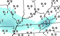
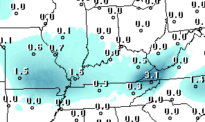
A storm system developing over central Missouri now will rapidly intensify under a very strong upper air flow over the Mississippi Valley and reach the Great Lakes by morning. Trailing the low pressure will be an eastward moving cold front. As the front moves into the warm, moist air thunderstorms will break out this evening and accelerate northeastward. The strong wind fields aloft will have no problems converting the thunderstorms into severe weather-makers quickly. During the evening, the biggest problems will be over ne TX, east OK and AR. By Midnight, the greatest threat pushes northward into eastern MO, IL and western IN. From Midnight until about 6 A.M., the models put a “bulls eye” over southern IL and southern IN for the greatest damage risk. NOTE: although the models zero in on the area north of the Ohio River, a few isolated severe storms could develop over western KY counties bordering the Ohio River.
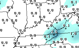
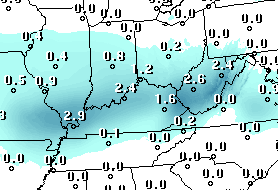
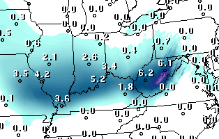
By 6 A.M. the severe storms should be over, or at least diminishing. By that time the remaining lines/clusters of thunderstorms will be approaching the Louisville area. The primary area of rain/storms should push through the I-65 corridor between 8 A.M. and Noon. Some strong winds may still be possible, but the primary threat for our area will be flash flooding. After the periods of heavy rain today, the ground is saturated. Additional heavy downpours tomorrow morning would be enough to trigger brief flash flooding.
The cold front is expected to pass though the Louisville area about Noon tomorrow so any additional severe weather generation tomorrow afternoon will be over eastern KY. Meanwhile, we’ll start a drying process during the afternoon as cooler air arrives.
Stuff
Sunday night’s big Oscar blunder wasn’t the first time that has happened. But, the first time it happened, the category wasn’t a major one. In 1964, the “Best Music Score” award was announced for the movie “Tom Jones.” But that movie wasn’t even nominated! The actual winner was Andre Previn for “Irma La Douce.”