Wed. Sept. 6, 2017
Imagery of Hurricane Irma’s eye from NASA’s new satellite from web site Watt’s Up With That?
The most fantastic eyewall video of a hurricane I’ve ever seen – #Irma

Wed. Sept. 6, 2017
Imagery of Hurricane Irma’s eye from NASA’s new satellite from web site Watt’s Up With That?
The most fantastic eyewall video of a hurricane I’ve ever seen – #Irma
5:45 P.M. Friday, April 21, 2017
Model solutions have done a flip-flop in the past 24 hours. Yesterday, the NAM gave by far the best weather outlook for Saturday’s events. Today the GFS is our friend. Which one is right? Good question! I’ve asked myself the same question many, many times over the years. Usually, there’s at least some “truth” in both models. The NAM, as expected, had a better take on today’s weather. Tomorrow, it appears to me that the GFS has a better handle on the situation. Here’s how I see it evolving:
First of the heavier rain systems moves into the Louisville area between 7 and 8 P.M. Rain could get heavy at times late tonight and tomorrow morning. Rain ends during the midday hours (Noon – 2 P.M.). Cloudy and cold rest of afternoon into the evening (50-ish temperatures likely). So, air show should be dry but a low-hanging cloud cover may hinder some of the action. For the fireworks, it’ll be breezy and cold (near 50). And, here’s where the NAM adds to the forecast – there’ll be about a 50-50 chance for light rain and/or drizzle during the show.
4:30 P.M. Thursday, April 20, 2017
Current situation:
Weak upper air system moving through the Great Lakes may create strong thunderstorms over NE Indiana and Michigan for the next few hours. We, however, are too far south to join in on the stronger dynamics with this system. Enough energy is left for us to (probably) see two episodes of showers and thunderstorms over the next 6-8 hours. A loosely organized line of showers/thunderstorms will move across the Louisville metro area between now and 6 P.M.
A second, better organized, system should bring a more widespread area of rain/thunder between 8 P.M. and 11 P.M. tonight.
Note: Models can’t agree about tomorrow: NAM brings a large area of rain over us tomorrow afternoon. GFS keeps us dry tomorrow with rain arriving tomorrow night. Either way, it will be cooler. (NAM looks better to me)
Air Show/Thunder:
Both models are developing the next weather system faster than they had earlier in the week. If this trend continues, it signals a better outlook for Saturday. Steady, heavier rains look to end by midday. Cloudy skies remain during the air show, but at least it should be dry. As cooler air arrives during the afternoon/evening we’ll see temperatures drop to the low to mid 50’s. Add breezy winds and a winter coat will feel good for the fireworks. In addition, Saturday evening could also be hit with a cold drizzle. Still, better than earlier forecasts.
Monday, March 27, 2017 5:30 P.M.
We’re on the northern edge of a Severe Thunderstorm Watch currently. Primary concern lies south of Louisville over central KY and, especially, central TN. Activity is due to a small, but intense upper level disturbance racing over the lower Ohio Valley. Once again, the upper dynamics are strong, but the lower level instability is quite weak. For the past few hours, clusters of thunderstorms have been moving NE from southern/southwestern KY. A few severe storm warnings have been issued, but it appears most of the storms, while strong, have stayed below severe limits (58 mph winds). Main factor for us has been the weakening of the storms as they encounter the more stable air mass near the Ohio River.
Main line of storms will push through the I-65 corridor (and Louisville area) between 6 and 7 P.M. this evening. Strong wind gusts and, perhaps, isolated spots of small hail will be likely as the line passes by. Overall, these storms should have little affect on our metro area.
BY 7 P.M. any storm threat for the Louisville are will end. Any additional threat for severe storms will continue east and southeast of us.
Stuff
A little late for the big day itself, but some things to remember about St. Patrick:
1). He was not Irish. (He was born in England, sold into slavery in Ireland as a child. He later escaped and returned to England where he became a priest. Then he returned to Ireland to help bring Christianity to Ireland.
2). It is true that there were no snakes in Ireland when Patrick died. However, there were no snakes in Ireland when he arrived as a priest. Irish snakes were destroyed about 10,000 years BEFORE Patrick’s era by the most recent Ice Age.
Monday, March 13, 2017 3 P.M.
Just looked out the window and saw some (very light) snow. Large area of precipitation on NWS radar moving slowly eastward should continue the snow for a couple of hours. No accumulation on roadways as temperatures are above freezing. Radar showing a classic “bright band” over Meade and northern Hardin Cos. That’s the area where the snow is melting aloft and thus creating a change from snow to rain. That snow-to-rain transition will reach the Louisville area by around 5-6 P.M.
Enjoy the snow while it’s still here.
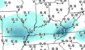
Friday, March 10, 2017 11:30 A.M.
Oh, so close! But apparently not close enough as this morning’s GFS and NAM continue to keep any snow tomorrow afternoon just a bit to our west and south. Plenty of moisture seems to be available, but both models place the primary area of atmospheric lift about 200 miles to our west tomorrow morning, then curving around to our south by evening. We’ll be watching a very cloudy sky…most likely with nothing falling from those clouds.
But, we’ll see another chance for light snow/flurries late Monday into Tuesday.
Latest GFS snow forecast from last night’s run:
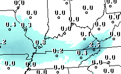
Thursday, March 9, 2017 5 P.M.
GFS’s most recent snow forecast:
NAM is also trending toward zero.
Saturday, Feb. 11, 2017 1 P.M.
A weak Alberta Clipper will push rapidly eastward across the lower Great Lakes tonight. Gusty southerly winds ahead of this system will bring us another unseasonably warm day although those winds are having trouble bringing moisture northward. However, it does appear likely we’ll see a little rain late tonight as the Clipper’s cold front pushes through. Rain will probably be only a few hundredths of an inch and end around daybreak tomorrow. Another windy day Sunday, but this time the winds will be from the northwest. Thus, colder weather – temperatures will be slowly falling through the 50’s during the day.
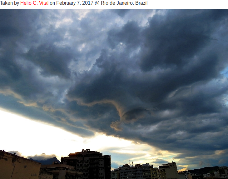
Intriguing photos
Got these from http://spaceweather.com They show a funnel cloud near Rio de Janiero a few days ago. They did not touch down and caused no damage. In Brazil they are called “tubes.”


Saturday, Jan. 28, 2017
Update from earlier…first of two small snowfalls mentioned earlier will stay south of Louisville…southern KY may see up to one-half inch.
Second (afternoon system) will have little moisture to work with so only a little snow shower activity is likely 2 P.M. to 6 P.M. with most areas getting no more than a dusting. No road problems expected with temperatures remaining above 32 degrees.
Winter Weather Advisory seems misguided to me.
Wednesday, Jan. 4, 2017
Interesting Alberta Low-type system will pass north of the area tomorrow. This system wasn’t given much credit as recently as yesterday (NWS had only a 40% chance for measurable snowfall Thursday. Now they’ve jumped to 2″-3″ of snow by late tomorrow.)
Models haven’t changed all that much, but the “official” forecast sure has. Models continue to place the best chance for snow over southern Indiana with I-64 about the southern edge of a possible 1″-3″ snow band. Louisville area should get around one inch (along with plenty of road problems). Snow appears likely to begin in Louisville by late morning and end during the evening rush hour.
More later.
THINK SNOW!