Category Archives: forecast

Add a few more clouds, but will they make rain?

Tuesday afternoon

A pocket of upper air moisture has been bringing us a thin layer of clouds, but the lower levels remain dry, so no rain is expected.  As mentioned yesterday, the appearance of 20%,30% or 40% chances for rain/t-storms in EVERY forecast period for the next 4-5 days is a good marker of uncertainty in weather forecasts.  While there is a varying chance for rain in every 12-hour period for at least the next 96 hours, I feel it’ll only happen in one or two of those periods.  Some examples:  tonight, too dry; tomorrow, marginal moisture, but upper air confluence says “no”; tomorrow night, decent chance, but it appears the rain/storm system will stay over the western third of KY, etc, etc.

I’ve never liked the “could happen” forecast although I must admit I used if often enough. Nevertheless, I much prefer the “will happen” over “could”.  However, in the summer my preference is an easy way to drive one crazy, what with all the little nuances than occur daily with thunderstorm systems.  That said, I’ll take my saw with me as I go out on the limb.  My two choices – Thursday daytime (possibly beginning early in the morning) and again Friday daytime.  Not good news for the PGA, but at least Saturday and Sunday look to be dry (from this far away).

Still quiet

Monday afternoon

Weather patterns remain weak and quiet – typical of late summer.  Models are trying to bring in several attempts for rain later this week, but, as often happens this time of year, most of them probably won’t pan out.  Looks dry through Wednesday, but there appears to be a minimal chance for rain both tomorrow night and again Wednesday night.  Best prospect  at this time looks like Thursday for some showers/thunderstorms.  But, Thursday is a long way away in a weak flow pattern, so anything could happen.  Meanwhile, hot days (near 90) and mild nights (mid 60’s) and very dry.

Odds and Ends

Sunday afternoon

Pretty calm weather – much like the weekend – will continue through Wednesday with temperatures rising a few degrees.  Next chance for rain looks like Wednesday night and especially Thursday.

Comet watch

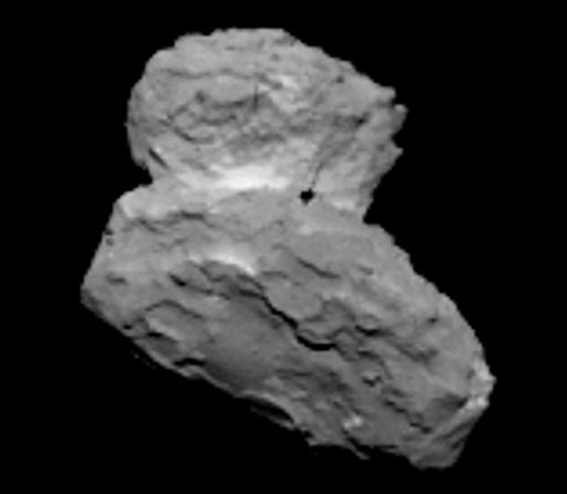
About 10 years ago the European Space Agency launched a space probe to visit a comet.  We’ve had a few fly-bys during the space age, but this one has different purposes.  Rosetta, as the probe is commonly known, is due to reach close to the Comet 67P/Churyumov/Gerasimenko  (Comet C-G  OR 67P for short) on Wednesday.  It will go into orbit around the comet and map its surface, looking for an appropriate landing space for the module Philae which has gone along for the ride.  If all goes well, a landing could take place as early as November.  So, while Rosetta studies what actually happens while a comet approaches the sun, Philae will try to find out exactly what the comet is made of.  It will be a phenomenal achievement (and knowledge advancement) if everything works as planned.  Keep your fingers crossed…the big news starts Wednesday.

Meanwhile, ESA recently issued this photo from Rosetta… Comet C-G  is shown about 1000 km from Rosetta.  67p_strip

Quiet weekend

Saturday afternoon

Mostly dry and warm today with one exception – a midday fading shower from Clark Co. which just barely made it across the Ohio River into Oldham Co.  Otherwise, plenty of sunshine and warm temperatures this afternoon and again tomorrow.  High tomorrow…mid to upper 80’s. Typical summer weather continues early next week.

Stuff

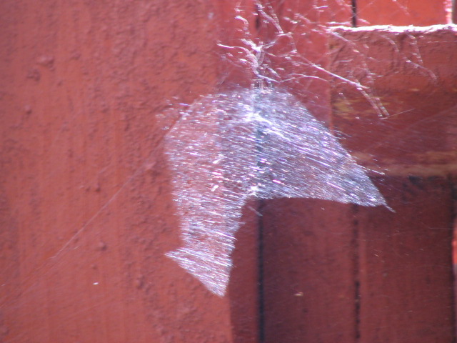
I was working in the yard today when something caught my eye.  It was a cobweb under my deck with a interesting patch of sunlight hitting it.  So I took a picture…017


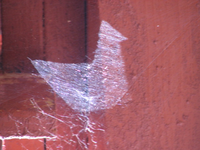
Then my mind suggested to me (I talk to my mind often, Is that okay?) to turn the photo upside down.  So I did…018

A white cardinal!  Nature does some funny things.

More stuff

The first missile fired in Operation Desert Storm bore the logo of the Louisville Slugger bat on it.  The crew hand-painted the logo while aboard the ship from which it was launched – the USS Louisville.

Heat and humidity return for the weekend.

Friday afternoon

August is off to a warm start, but at least the humidity is still low.  That all changes for the weekend as both the temperatures and the humidity will be on the rise.  And the models continue their slow decline in rain chances.  So, it looks like a pretty typical late summer weekend…hazy, very warm and humid.  Rain/thunderstorm chances are not zero, but pretty close.  Best chance still looks like tonight, but only at 20% or less.  Saturday and Sunday rain chances will max out under 10%.  Temperatures tonight should drop to around 70 and about 72 Sunday morning.  High temperatures should reach the upper 80’s.  Similar weather should continue early next week.

More climate talk

Yesterday, I closed with a statement about the headlines concerning a return to “an ice age is coming” within the next ten years.  That was not said in jest to mock the climate claims of the past century.  Rather, it’s based on observations of past reactions of weather to ocean currents.  Yes, ocean driven weather cycles.  The two major patterns are the Pacific Decadal Oscillation (PDO) and the Atlantic Multidecadal Oscillation (AMO).  Both the PDO and the AMO have two phases – positive(warm) and negative(cold).    The PDO was generally in a positive mode from the mid 70’s (when recent global warming began) until it flipped to the cold negative mode around the year 2000.  The Earth hasn’t warmed since.  (What a coincidence!) Meanwhile, the AMO has been generally positive much of the past 25-30 years.  A few years back it started “flipping” but hasn’t settled into the cold mode yet.  It’s expected to definitely become a cold phase over the next year or two.  Historically, when both the PDO and the AMO are in their cold phase, the Earth cools.  (Coincidence?  our warm Earth climate leaders think so.)

Another possible contributer to cooling could be sunspots.  The sun, of course, is the reason why we a here.  But, for centuries we looked for the “solar constant” the exact amount of energy the sun sends our way each day.  For some reason, the scientific community thought this number had to be a constant.  It’s extremely difficult to measure the sun’s energy through the atmosphere, so the answer was never found…until satellites arrived.  Then, we could easily measure that solar constant.  But, it turns out there is no solar constant – the sun’s output varies on a cycle that closely matches the number of sunspots.  Currently we are at the end of a “solar max” that has been the weakest since around 1900.  Low sunspot numbers then were associated with a “cooling Earth”.  Even lower minimums have occurred.  The most well known is the Maunder Minimum – a period of over 100 years of very low sunspot numbers centered over the 1700’s – right in the middle of the period known as the Little Ice Age.  (Another coincidence?  you betcha! says the warm Earth society.)

ALL the CLIMATE MODELS our country’s so-called experts use project temperatures on a straight line upward from 2000 until 2020.  Well, we’re 70% of the way there and temperatures haven’t budged.  Let’s see how things stand in 6 years – I’m betting on colder.

Cool weather is over for awhile

Thursday afternoon

No problems with our weather recently and perhaps just a few bumps in the road over the next few days.  The basic features have remained the same.  Weak upper air disturbances will drift over the region late tomorrow through Sunday, but the main moisture source will stay far south and east of our area.  So, the already weak upper systems shouldn’t be able to produce some light and scattered showers.  At the moment, the most likely time for any showers looks to be Friday night.   Skies should be partly cloudy with highs in the upper 80’s and lows creeping up to the 70-72 range.  Highest rain probability will be 30% for Friday night.

Climate controversy continues

Hard on the heels of my comments yesterday concerning Earth’s warming during the 20th century.  Turns out that the warming (probably aided somewhat by carbon dioxide) was highly beneficial to mankind.  Our government scientists won’t tell us that because it ruins the story they’ve been trying to sell us – that carbon dioxide is evil and will destroy us. Fact is carbon dioxide has been crucial to the development and maintenance of life on Earth.  Without it, we wouldn’t be here.

Well, today’s report  on www.wattsupwiththat.com   shows that the “climate crisis” is a variable thing…and it runs on roughly a 40-year cycle.  A warming Earth was the big concern for about the first 40 years of the century.  Cooling began in the 1940’s and the “an ice age is coming” crowd got very loud in the early 1970 ‘s.   Then, warming resumed  and by the late 1980’s the cry “we’re killing ourselves with carbon dioxide” started to become very loud.  And it’s still going strong… in spite of the fact that Earth has not warmed  this century.  By my reasoning, we should be back to the ice age warnings within the next ten years!.

Here’s that data chart from www.wattsupwiththat.com 


  • 1895 Geologists Think the World May Be Frozen Up Again New York Times, February 1895
  • 1902 – “Disappearing Glaciers…deteriorating slowly, with a persistency that means their final annihilation…scientific fact…surely disappearing.” – Los Angeles Times
  • 1912 Prof. Schmidt Warns Us of an Encroaching Ice AgeNew York Times, October 1912
  • 1923 – “Scientist says Arctic ice will wipe out Canada” – Professor Gregory of Yale University, American representative to the Pan-Pacific Science Congress, – Chicago Tribune
  • 1923 – “The discoveries of changes in the sun’s heat and the southward advance of glaciers in recent years have given rise to conjectures of the possible advent of a new ice age” – Washington Post
  • 1924 MacMillan Reports Signs of New Ice Age New York Times, Sept 18, 1924
  • 1929 – “Most geologists think the world is growing warmer, and that it will continue to get warmer” – Los Angeles Times, in Is another ice age coming?
  • 1932 – “If these things be true, it is evident, therefore that we must be just teetering on an ice age” – The Atlantic magazine, This Cold, Cold World
  • 1933 America in Longest Warm Spell Since 1776; Temperature Line Records a 25-Year Rise New York Times, March 27th, 1933
  • 1933 – “…wide-spread and persistent tendency toward warmer weather…Is our climate changing?” – Federal Weather Bureau “Monthly Weather Review.”
  • 1938 – Global warming, caused by man heating the planet with carbon dioxide, “is likely to prove beneficial to mankind in several ways, besides the provision of heat and power.”– Quarterly Journal of the Royal Meteorological Society
  • 1938 – “Experts puzzle over 20 year mercury rise…Chicago is in the front rank of thousands of cities thuout the world which have been affected by a mysterious trend toward warmer climate in the last two decades” – Chicago Tribune
  • 1939 – “Gaffers who claim that winters were harder when they were boys are quite right… weather men have no doubt that the world at least for the time being is growing warmer” – Washington Post
  • 1952 – “…we have learned that the world has been getting warmer in the last half century” – New York Times, August 10th, 1962
  • 1954 – “…winters are getting milder, summers drier. Glaciers are receding, deserts growing” – U.S. News and World Report
  • 1954 Climate – the Heat May Be OffFortune Magazine
  • 1959 – “Arctic Findings in Particular Support Theory of Rising Global Temperatures” – New York Times
  • 1969 – “…the Arctic pack ice is thinning and that the ocean at the North Pole may become an open sea within a decade or two” – New York Times, February 20th, 1969
  • 1969 – “If I were a gambler, I would take even money that England will not exist in the year 2000″ — Paul Ehrlich (while he now predicts doom from global warming, this quote only gets honorable mention, as he was talking about his crazy fear of overpopulation)
  • 1970 – “…get a good grip on your long johns, cold weather haters – the worst may be yet to come…there’s no relief in sight” – Washington Post
  • 1974 – Global cooling for the past forty years – Time Magazine
  • 1974 – “Climatological Cassandras are becoming increasingly apprehensive, for the weather aberrations they are studying may be the harbinger of another ice age” – Washington Post
  • 1974 – “As for the present cooling trend a number of leading climatologists have concluded that it is very bad news indeed” – Fortune magazine, who won a Science Writing Award from the American Institute of Physics for its analysis of the danger
  • 1974 – “…the facts of the present climate change are such that the most optimistic experts would assign near certainty to major crop failure…mass deaths by starvation, and probably anarchy and violence” – New York Times

Cassandras are becoming increasingly apprehensive, for the weather aberrations they are studying may be the harbinger of another ice age

  • 1975 Scientists Ponder Why World’s Climate is Changing; A Major Cooling Widely Considered to Be InevitableNew York Times, May 21st, 1975
  • 1975 – “The threat of a new ice age must now stand alongside nuclear war as a likely source of wholesale death and misery for mankind” Nigel Calder, editor, New Scientist magazine, in an article in International Wildlife Magazine
  • 1976 – “Even U.S. farms may be hit by cooling trend” – U.S. News and World Report
  • 1981 – Global Warming – “of an almost unprecedented magnitude” – New York Times
  • 1988 – I would like to draw three main conclusions. Number one, the earth is warmer in 1988 than at any time in the history of instrumental measurements. Number two, the global warming is now large enough that we can ascribe with a high degree of confidence a cause and effect relationship to the greenhouse effect. And number three, our computer climate simulations indicate that thegreenhouse effect is already large enough to begin to effect the probability of extreme events such as summer heat waves. – Jim Hansen, June 1988 testimony before Congress, see His later quote and His superior’s objection for context
  • 1989 -“On the one hand, as scientists we are ethically bound to the scientific method, in effect promising to tell the truth, the whole truth, and nothing but – which means that we must include all doubts, the caveats, the ifs, ands and buts. On the other hand, we are not just scientists but human beings as well. And like most people we’d like to see the world a better place, which in this context translates into our working to reduce the risk of potentially disastrous climate change. To do that we need to get some broad based support, to capture the public’s imagination. That, of course, means getting loads of media coverage. So we have to offer up scary scenarios, make simplified, dramatic statements, and make little mention of any doubts we might have. This “double ethical bind” we frequently find ourselves in cannot be solved by any formula. Each of us has to decide what the right balance is between being effective and being honest. I hope that means being both.” – Stephen Schneider, lead author of the Intergovernmental Panel on Climate Change, Discover magazine, October 1989
  • 1990 – “We’ve got to ride the global warming issue. Even if the theory of global warming is wrong, we will be doing the right thing – in terms of economic policy and environmental policy” – Senator Timothy Wirth
  • 1993 – “Global climate change may alter temperature and rainfall patterns, many scientists fear, with uncertain consequences for agriculture.” – U.S. News and World Report
  • 1998 – No matter if the science [of global warming] is all phony . . . climate change [provides] the greatest opportunity to bring about justice and equality in the world.” —Christine Stewart, Canadian Minister of the Environment, Calgary Herald, 1998
  • 2001 – “Scientists no longer doubt that global warming is happening, and almost nobody questions the fact that humans are at least partly responsible.” – Time Magazine, Monday, Apr. 09, 2001
  • 2003 – Emphasis on extreme scenarios may have been appropriate at one time, when the public and decision-makers were relatively unaware of the global warming issue, and energy sources such as “synfuels,” shale oil and tar sands were receiving strong consideration” – Jim Hansen, NASA Global Warming activist, Can we defuse The Global Warming Time Bomb?, 2003
  • 2006 – “I believe it is appropriate to have an over-representation of factual presentations on how dangerous it is, as a predicate for opening up the audience to listen to what the solutions are, and how hopeful it is that we are going to solve this crisis.” — Al Gore, Grist magazine, May 2006
  • 2006 – “It is not a debate over whether the earth has been warming over the past century. The earth is always warming or cooling, at least a few tenths of a degree…” — Richard S. Lindzen, the Alfred P. Sloan professor of meteorology at MIT
  • 2006 – “What we have fundamentally forgotten is simple primary school science. Climate always changes. It is always…warming or cooling, it’s never stable. And if it were stable, it would actually be interesting scientifically because it would be the first time for four and a half billion years.” —Philip Stott, emeritus professor of bio-geography at the University of London
  • 2006 – “Since 1895, the media has alternated between global cooling and warming scares during four separate and sometimes overlapping time periods. From 1895 until the 1930’s the media peddled a coming ice age. From the late 1920’s until the 1960’s they warned of global warming. From the 1950’s until the 1970’s they warned us again of a coming ice age. This makes modern global warming the fourth estate’s fourth attempt to promote opposing climate change fears during the last 100 years.” – Senator James Inhofe, Monday, September 25, 2006
  • 2007– “I gave a talk recently (on fallacies of global warming) and three members of the Canadian government, the environmental cabinet, came up afterwards and said, ‘We agree with you, but it’s not worth our jobs to say anything.’ So what’s being created is a huge industry with billions of dollars of government money and people’s jobs dependent on it.” – Dr. Tim Ball, Coast-to-Coast, Feb 6, 2007
  • 2008 – “Hansen was never muzzled even though he violated NASA’s official agency position on climate forecasting (i.e., we did not know enough to forecast climate change or mankind’s effect on it). Hansen thus embarrassed NASA by coming out with his claims of global warming in 1988 in his testimony before Congress” – Dr. John S. Theon, retired Chief of the Climate Processes Research Program at NASA, see above for Hansen quotes

Section updated by Anthony:

  • 2009Climate change: melting ice will trigger wave of natural disasters. Scientists at a London conference next week will warn of earthquakes, avalanches and volcanic eruptions as the atmosphere heats up and geology is altered. Even Britain could face being struck by tsunamis – “Not only are the oceans and atmosphere conspiring against us, bringing baking temperatures, more powerful storms and floods, but the crust beneath our feet seems likely to join in too,” – Professor Bill McGuire, director of the Benfield Hazard Research Centre, at University College London, – The Guardian, Sep 2009.
  • 2010What Global Warming Looks Like. It was more than 5°C (about 10°F) warmer than climatology in the eastern European region including Moscow. There was an area in eastern Asia that was similarly unusually hot. The eastern part of the United States was unusually warm, although not to the degree of the hot spots in Eurasia. James HansenNASA GISS, August 11, 2010.
  • 2011Where Did Global Warming Go? “In Washington, ‘climate change’ has become a lightning rod, it’s a four-letter word,” said Andrew J. Hoffman, director of the University of Michigan’s Erb Institute for Sustainable Development.   – New York Times, Oct 15, 2011.

  • 2012Global warming close to becoming irreversible-scientists. “This is the critical decade. If we don’t get the curves turned around this decade we will cross those lines,” said Will Steffen, executive director of the Australian National University’s climate change institute, speaking at a conference in London. Reuters, Mar 26, 2012
  • 2013Global-warming ‘proof’ is evaporating.  The 2013 hurricane season just ended as one of the five quietest years since 1960. But don’t expect anyone who pointed to last year’s hurricanes as “proof” of the need to act against global warming to apologize; the warmists don’t work that way. New York Post, Dec 5, 2013
  • 2014  – Climate change: It’s even worse than we thought.  Five years ago, the last report of the Intergovernmental Panel on Climate Change painted a gloomy picture of our planet’s future. As climate scientists gather evidence for the next report, due in 2014, Michael Le Page gives seven reasons why things are looking even grimmer. – New Scientist (undated in 2014)


The actual Global Warming Advocates’ chart, overlaid on the “climate change” hysterics of the past 120 years. Not only is it clear that they take any change and claim it’s going to go on forever and kill everyone, but notice that they even sometimes get the short-term trend wrong…

climate-claims

Worse still, notice that in 1933 they claim global warming has been going on for 25 years…the entire 25 years they were saying we were entering an ice age. And in 1974, they say there has been global cooling for 40 years…the entire time of which they’d been claiming the earth was getting hotter! Of course NOW they are talking about the earth “warming for the past century”, again ignoring that they spent much of that century claiming we were entering an ice age.

The fact is that the mean temperature of the planet is, and should be, always wavering up or down, a bit, because this is a natural world, not a climate-controlled office.

 

Returning to normal.

Wednesday Afternoon

The run of pleasant weather is beginning its fade.  Another cool night then back to the mid 80’s (at least the humidity remains low ).  By Friday, a  bit warmer and more humid.  The NAM and GFS continue to bring some very weak upper air systems into the area by late Friday into Sunday.  Both models continue to keep any significant moisture south and east.  There could be some substantial rains along the Appalachians this weekend, but it looks like the systems will be unable to get much water this far north. So beginning late Friday, we will continue with small chances for a small amount of rain.

GFS projects the near normal weather pattern to continue for at least the first half of next week.

Climate/Commentary

I couldn’t believe my eyes!  Right there in the CJ before my very own eyes was a story released by the Government stating that cold weather kills far Americans than hot weather annually.  Of course, this is not news.  However the current “climate crisis” crew that seems to control our national government’s science just doesn’t (ordinarily) let that kind of information be released to the public.  Cold is worse than warm concerning mortality.  Fifty years ago the statistics were roughly 2 to 1.  Now, it runs closer to 1.5 to one.  Does that mean that cold air deaths are actually falling.  In this case the answer is yes.  Does that mean that Earth’s warming has actually been good for us?  Yes.  The things that have improved are almost uncountable.  Probably the most important has been the amazing increase in food production (not solely because of warming)  that feeds several billion more people than when the 20th century began.  Interestingly, 40-50 years ago some highly respected scientists were forecasting that by the end of the 20th century, the Earth would be in constant famine and on its way to destruction by constant food wars!  Sounds very similar to what a lot of famous “scientists” are proclaiming about a warming Earth. So, far the warming has been very beneficial, but there’s been no warming for the past 15 years!

Another break from heat and humidity

Tuesday midday

Very pleasant (and unusual) July weather continues and should last, although with slowly warming day by day through Thursday.  When we get these below normal temperatures they are brought in by upper level troughs (basically a huge pocket of colder than normal air aloft.  This destabilizes the atmosphere so that daytime heating tends to generate a large amount of afternoon cloudiness.  You saw it yesterday and we’ll see it again today and tomorrow.  Sometimes there is enough moisture to produce a small amount of precipitation.  An example is snow flurries after the arrival of a blast of cold air.  When it happens in the summer, once in awhile it generates some small, light showers.  Today’s models bring in a little more moisture than yesterday, So, is possible we could see a few brief showers this afternoon and evening, especially over southern Indiana.

Starting Friday, the chance for rain will return.  GFS and NAM are pretty weak with this next system.  It will definitely be moisture-shy as upper level winds will stay from the northwest.  So, it’s a good thing we got some pretty good rains last weekend.

Space news

The summer’s best time for viewing meteor showers comes in August with the Perseid Shower.  This year’s peak is expected to be August 11-13.  However, it won’t be nearly as “viewable” as most years.  The peak coincides with the largest, brightest full moon of the year.  So, the usual predictions of “up to 120 per hour”  have been lowered to about 30 per hour.

Astronomers have been watching the skies for possible asteroids that could be on collision paths with Earth.  As of today, we know of 1493 Potentially Hazardous Asteroids. These PHAs, as they are commonly known are defined as asteroids which are greater than 100 meters in diameter and have orbits that bring them within 5 million miles of Earth.  An impact would be devastating to our Earth, but at this time none is known to have an orbit that would create a direct impact here.  That’s the good news, the bad news is that PHAs are still being discovered.

Stuff

On September 16, 1921, a baby boy born in East London, England, was reported to have been born with 14 fingers and 15 toes.

The average American uses  about 168 gallons of water a day.

Long run of pleasant weather lies ahead

Midday Sunday

What a night!  The first midwestern system did arrive a little early with some strong winds, some scattered minor damage, lots of lightning and a very much needed significant rainfall.   Then, the second system arrived right on schedule around 5 A.M with a repeat of the first system.  Storms are now moving rapidly away and skies should slowly clear this afternoon.  Seasonably cool, dry weather should be the weather pattern through much of the upcoming week.

Note: a Tornado Watch covers much of Kentucky south and east of Louisville.  However, as of 1:15 this afternoon, the line of potentially damaging thunderstorms has moved southeast of a line from Lexington to Bowling Green.  So, no one within a 50-mile radius of Louisville is in any danger from thunderstorms this afternoon.

Just what is a severe Thunderstorm?

The National Weather Service defines a severe thunderstorm as having large hail, at least 3/4 inches (0.75 inches) in diameter, and/or damaging winds, at least 58 mph, or 50 knots

58 mph winds are really strong.  They do lots of damage.  They are pretty rare around here.  Last night’s two rounds of thunderstorms generated  plenty of warnings but not a whole lot of damage.   (There’s an old story to answer the question posed by this article -“If the whole neighborhood has several large limbs and trees down,  but my property is untouched, it was a strong storm.  However if my neighborhood has no damage, but I’ve got a big limb down, it was a severe storm.”)

There’s an old saying in the weather business that states a few trees down DOES NOT a severe thunderstorm make!   Very true.  Thunderstorm (and non-thunderstorm) winds can do  tree (and other) damage with wind speeds as low as 30-35 mph.  As the winds increase so does the ability to do damage.  For instance, a wind gust of 60 mph has 44% MORE FORCE to work with compared to a 50 mph gust.

I looked at last night’s data from area airports.  The HIGHEST wind gusts recorded were at Ft. Knox – 32 mph.  Lexington, both Louisville airports, Bowling Green, Huntingburg (IN), and Frankfort had top wind gusts in the 20’s.  Louisville’s Standiford Field’s top gust was 23 mph (at 5 P.M., when the skies were sunny).

I also checked the Kentucky Mesonet.  The highest gust around the state was in Bullitt County with a gust to 53.4 mph.  Hardin, Shelby and Taylor Counties all measured around 49 mph while just about everyone else was in the 30’s or lower.  Now one wind, measured at a single site, does not mean it has to be the highest in that county.  Thunderstorm wind gusts can vary quite a bit over short distances.  Case in point being Franklin County.  The airport’s top gusts overnight were in the mid 20’s (they’ve  had a higher gust this morning) while the mesonet station reached 41.3 mph.

But, when you look at several dozen reports and the large majority only saw max gusts in the 20’s and 30’s, you have to believe that the outliers  in Bullitt, Shelby and Oldham Cos. were probably pretty close to the top of nature’s production overnight.  It’s quite likely parts of Bullitt County reached the magic 58 mph target.  Possibly parts of Shelby and Oldham also reached it.

So,  by the actual “ground truth” of the raw data, our region did not have any severe thunderstorms last night.  But, based on interpretation of the data distribution, it’s likely a few spots(but only a few)  did reach the 58 mph hour criteria.  There were plenty of Warnings issued, there was some damage, but did we have any “severe” storms  based on the official definition?  Well, as the little story at the beginning of the essay illustrates, It’s all in YOUR perception!

Another update

Saturday afternoon

Recently, radar indicates the third system I mentioned earlier has organized faster than thought.  So, the time line I just issued should probably be shifted forward a few hours.  Showers/tstorms could reach the Louisville area as early as 10 P.M.  If so, that will increase chances for severe storms locally.