Monthly Archives: August 2014

Weekend update

Saturday 5 P.M.

There’s an area of (mostly) light rain coming eastward from western Indiana.  It is weakening, and expected to continue that trend, but it should hold together long enough to bring some light rain to the Louisville area between roughly 7-9 P.M. this evening.

The rest of the weekend outlook looks pretty much on course (see yesterday’s post, below).  Slightly better chance –  about 30-40% – . for showers/t-storms tomorrow  until late afternoon.  The primary rain/storm chance remains tomorrow night and Monday.  There could be some pockets of heavy rain, but the GFS and NAM have reduced their rain total forecast from yesterday (especially the NAM) AND the HPC has dropped their forecast from 2″+ yesterday to 1 – 1.50″ today.


Good weather most of the weekend

Friday Afternoon

As usual with summertime weather patterns, conditions change very slowly.  But, that can make a large change in rainfall patterns and production.  That goes for this weekend.  Several upper air systems will make a run at us, so we’ll see plenty of clouds and higher humidity, but any significant rain may hold off until Sunday night into Monday.  Here’s how it is shaping up…

A weak upper air system will pass over us late tonight.  It’ll bring us plenty of mid and high level clouds so temperatures should be quite a bit warmer tonight (mid 60’s).  A mix of clouds and sunshine tomorrow as we wait for the next disturbance to arrive.  Highs should be in the mid 80’s.  The next system is somewhat better organized, but is expected to stall by late tomorrow over Missouri.  That may be close enough to push some showers/thunderstorms into our area tomorrow night.  However, it probably won’t  – just about a 20-30% for rain Saturday night.  The Missouri system will probably begin to drift eastward by late Sunday, thus we’ll see our highest rain chances Sunday night into Monday.  (Also, possibly late Sunday afternoon.

The Weather Service’s rain amount prediction group is really big on this system – they are forecasting 2″+ for all of our area from Saturday night through Monday night.  The fact that everything will be so slow moving can certainly add to higher rain totals, but the whole area getting 2″+ inches would certainly be a big surprise to me.

Brief showers

Thursday afternoon

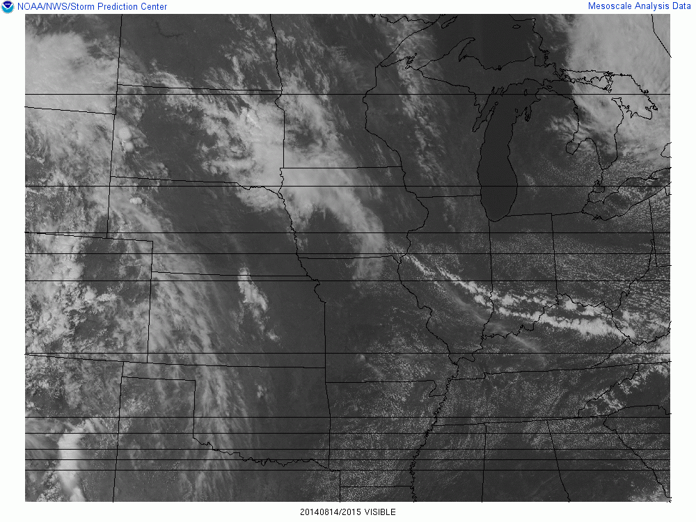
A line of light showers moving through the afternoon won’t last very long.  We seem to find ourselves in the wrong spot at the wrong time situation.  A look at the satellite image belowvissatshows two lines of clouds with light showers being produced by a weak cold front pushing southward.  These showers will fade before sundown, but the cooler air will reinforce the pleasant, dry air mass we’ve been enjoying.  (By the way, good call by the National Weather Service to add in that chance for showers this afternoon.

If you look to the upper-center( Iowa, Minnesota and South Dakota) of the image you will see the classic satellite view of an upper level disturbance.  This one will drop slowly southeast and bring us increasing cloudiness by late tomorrow.  As the system crosses north of us on Saturday, we’ll see a lot of clouds (with a small chance for some light showers) early in the day, The primary effect this system will have on us will be to bring in much higher humidity.  Then, as skies clear Saturday afternoon, We’ll really know that summer’s definitely not finished.  Once the humidity  is in place all we have to do is wait.  A few more of those upper air disturbances are expected to follow the one on the satellite image above.  Some periods of showers/thunderstorms should become more likely, perhaps early Sunday, but a better chance late Sunday and Monday.


Changes coming from the Storm Prediction Center

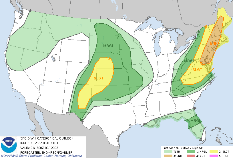
For years we’ve been receiving “Severe Storm Outlooks” from the Storm Prediction Center with three familiar categories – Slight Risk, Moderate Risk and High Risk.  These Convective Outlooks, as they are officially known, appear as maps showing locations where the forecasters expected the possibility for thunderstorms that day and pinpoint areas where they believe severe storms are possible.  The slight, moderate and high risk delineate areas based on the expectations where the most widespread and intense severe storms will be located.

That system will end October 22.  The types of outlooks will grow to five with the addition of “marginal” and “enhanced”.  It is very hard for a forecaster to just draw a line separating expected non-severe and severe regions.  It’s my belief that most of the time, SPC forecasters use the “better safe than sorry” philosophy.  As a result, I believe that in general practice the daily “Slight Risk” category is considerably larger than it should be.  So, I’m happy to see the addition of the Marginal Risk category.  This should eliminate the problems with the lower end of the storm spectrum and ease the worry many people have when they hear “Slight Risk” in the morning.

The “Enhanced Risk”  category covers the border between Slight and Moderate, also a   confusing boundary.  The jump from slight to moderate currently means higher areal coverage AND more numerous and intense storms (over a 10,000 square mile area, say).  Nature doesn’t always cooperate, however, especially when you have two specific criteria to satisfy.  For instance, suppose the area to be hit exceeds the “slight” criteria, but the storms aren’t expected to exceed low-level severe?  Or, vice-versa?   Enter “Enhanced Risk” for that “fuzzy”  zone.  Here’s an example of what it will look like.spcoutlooks


Here we go again

Tuesday Afternoon

It’s back!  The pleasant, mild, dry days of August.  Now there’s a statement you don’t here too often.  But, this summer has produced an abundance of them with at least two more to go in this current sequence.  Clear, cool nights should produce nighttime lows in the lower 60’s (upper 50’s rural areas) while daytime highs return to the upper 70’s tomorrow then slowly warm into the 80’s Thu/Fri.  A situation somewhat similar to the one we had this past weekend appears to be shaping up in the longer range guidance – we’ll just have to wait and see.

Super Moon among the missing.

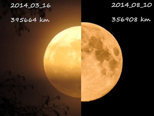
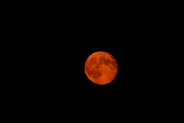
Thanks to the clouds and showers most of the lower Ohio Valley didn’t get a chance to view this year’s “Super Moon.”  Super moon is the name given to the full moon that occurs when the Earth-Moon distance is the least of the year.  The distance between Earth and Moon varies because the Moon revolves around us in a slightly elliptical orbit.  The super moon can be as much as 14% larger and normal full moons and up to 30% brighter.  The photos below are from www.spaceweather.com.   The comparison was made by Vese Vauhkonen of Finland.supermoon_strip

The super moon was roughly 50,000 km (about 30,000 mi) closer to Earth than the picture on the left.

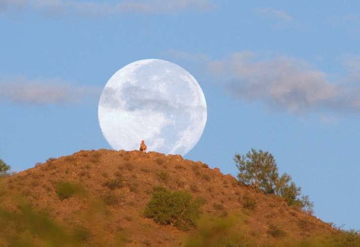
Here are some otherssupermoon 2 supermoon 3 supermoon 4

Another showery day

Monday Afternoon

Good support for additional showers mid to late afternoon and possibly into the evening.  But we are finally seeing a change in the upper air wind pattern.  As has happened on a regular basis this summer, an upper level trough – not as strong as several we’ve seen this summer – is digging southward from the Great Lakes and will push away the persistent humid and shower-laden weather we’ve had since Friday.  Another cool, dry air mass will be moving in tonight and tomorrow.  With more sunshine, daytime highs should be just a little below the highs of the past four days, BUT with much lower humidity, it will feel much better at least through Thursday.

What’s in a name?

After World War II our Earth settled into a gradual cooling trend.  So much so, that by the late 1960’s into the 70’s, climate specialists (I use the term loosely) were proclaiming the arrival of a new Ice Age.  Then, a funny thing happened.  Earth started warming. The fervor started slowly but really picked up in 1988 when that world-famous scientist Al Gore (he has one college-level science class to his credit – got a D) and astronomer James Hansen really got the ball rolling on the global warming scare.  At the time, I was very curious about the fuss being made.  After all, our Earth has been slowly warming since the last ice age ended roughly 12,000 years ago.  Yes, there have been long periods of ups and downs over those years, but the long term trend has always been up.

Oh, but this time was different!  Now, it was OUR fault.  Anthropogenic Global Warming!  This was something new and we’re going to save the world.  I’d been in the weather business over 20 years at that time and I’m thinking…”hmm, human produced changes in our weather/climate.  Didn’t we study about that for quite awhile back in college in, of all places, Climatology class?”  Of course we did.  Mankind has been altering, changing, manipulating, and doing numerous other things to Earth for thousands of years.  The surface of the Earth today  wouldn’t even recognize itself from a picture of the earth 1000 years ago.  Has our weather/climate changed because of our activities?

YES!  But, we don’t know in what ways.  You can’t make as many changes as we’ve made and not have an effect on our atmosphere.  So, what have we done about it?  We’ve adapted.  And, if we want to continue as the dominant animal on the Earth, we’re going to have to continue adapting.  The “newly discovered” AGW was laughable.  The talk about reversing AGW was even more laughable, even to the point of being hilarious (to me).

As we head through the 1990’s, the fever keeps growing.  More and more “studies” come out proclaiming the horrible future that awaits.  I’m thinking how difficult weather forecasting is with a 1-2 day window.  Things usually get very iffy by days 5-7.  And, these climate studies are ALL based on computer “climate models” which have never been proven to work.  Somewhere during my trip through the 90’s I had one of those “Duh” moments.  This is NOT science.  This IS political!

Crossing over into the 2000’s, two additional important things have happened.  On the political front a new administration whose science advisers actually believe this climate mysticism and are pushed it on us.  So far we’ve spent 100’s of millions, perhaps billions, of our tax dollars on studies based on models that do not work (phony science) AND projects that produce high priced  energy to replace the lower priced energy  we should be getting.  Think of all the truly useful things that could have done with that money if it had been placed into rebuilding our nation’s infrastructure.  ADAPTATION

The second important event so far this century has been that global warming has stopped. No warming at all this century!  When it became obvious that the warming had stopped, the climate alarmists were pretty nimble – have you heard “global warming” much in the past 6-10 years?  Certainly not, suddenly our greatest fear became Climate Change.  This is pretty stupid, of course, since our climate is always changing” but the perpetrators  have been very skillful proclaiming that this is the next big threat to our existence.

But, now that Earth has not warmed for well over a decade, that climate change thing just doesn’t sound right either.  So, I’ve picked up on a few government releases in the past week or so now referring to Climate Pause.  Don’t they know that our climate never stops or pauses?  Our tax dollars are working hard!

Stuff

Valhalla must have the world’s best drainage system for their greens.  And the drainage on the fairways seemed very good as well.  Nice job.

Freaky event this mornning

Friday afternoon

Overnight a large area of showers over western IN and western KY slowly moved toward Louisville.  I hadn’t expected them to make it here, but they arrived around sunrise and produced, in general, a light (.10 to .20″) rain over the area – with ONE major exception!  Radar rain estimates were quite uniform except for one small area.  Southwestern Jefferson County got a huge rain burst around 6-7:30 this morning.  Nothing unusual anywhere around that one area, but a narrow streak from the airport southwest to near the Ohio River received 1-2″ of rain during that time!  It’s a good thing that didn’t hit Valhalla.

A second rain area passed through from around 10 A.P. until 1 P.M. and additional scattered showers have remained in the area since then.  As of 5 P.M. scattered  showers can be seen in all directions from Louisville, so a few more showers may hit town before nightfall.  Higher chance for additional showers this evening will be east of Louisville.

Tomorrow and Sunday we’ll still be left with this warm and humid air mass AND the models continue to drift weak upper level energy pockets our way.  The result shouldn’t be quite the same, however.  Any storms should be disorganized and spotty.  Although a majority of us should hear thunder and perhaps see a brief thunderstorm, most of the day will be dry with more abundant sunshine pushing temperatures back into the mid 80’s or so.  Sunday looks quieter still – fewer pop-up thunderstorms and they should be late in the day – after the PGA crowns its champion

Rain creeping slowly toward us.

Thursday afternoon

The upper level waves of energy are slowly working into position to finally visit the lower Ohio Valley.  Today’s system is slowly spinning southward along the east side of the Mississippi from Illinois to western KY.  I expect it to drift  southward and fade away this evening and tonight, so it poses very little threat to our area.  However, I’m still concerned about of couple of upper air remnants from today’s system.  The GFS continues to bring the energy across KY in two pieces – the first one being the system tonight which I expect to have minimal impact here. The trailing energy pocket should take direct aim on us, with a high chance for showers/thunderstorms tomorrow from about 10 A.M. until 4 P.M. or so.  Yesterday, the NAM wasn’t buying that scenario but has moved closer to the GFS reasoning today.

Another problem has popped up for the weather Saturday.  The GFS has picked up on another weak pocket of energy coming over the Rockies.  While the general trend is to weaken this system, it is projected to move over(or near) us Saturday.  Thus, my previously dry Saturday forecast doesn’t look like it’ll hold up.  Tomorrow’s system will take some of the upper air moisture along as it heads east.  Less moisture and a weakening energy pocket should still be able to at least generate some scattered thunderstorms.  But, let me emphasize the scattered, hit ‘n’ miss nature expected Saturday as compared to a longer, more widespread outbreak expected Friday.

With thunderstorm outbreaks you can never be certain what’s going to happen, but that’s how it looks for me now.

Rosetta arrives!

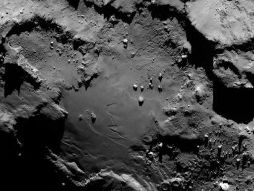
A few days ago, we mentioned the European Space Agency’s (ESA) space probe Rosetta approaching comet 67P.  After a ten year journey it arrived about 130 km away from the comet core and will now spend the next month or so jockeying into an orbit about 30 km (20 miles) from the surface.  Here’s how the comet looked at a distance of 130 km from Rosetta…photo courtesy of ESA.

rosetta


As humidity grows, so does the chance for rain.

Wednesday morning

Little change from yesterday except the humidity has finally reached uncomfortable levels again.  So, with higher humidity to work with we have to start taking those ever present “rain chances” a bit more seriously.  But it takes more than heat and humidity to make it rain.  The upper level wind patterns have a lot to say about it as well.  For instance, yesterday we had a weak upper air disturbance pass over – plenty of clouds, but the lower atmosphere was so dry that rain didn’t form.  A similar disturbance today, would probably bring us some rain.  So, now that the surface air is “primed” the upper air energy becomes critical.

In general, the models seem pretty consistent with their placement of the next several of these minor upper disturbances.  However, the timing does vary.  Trying to make some sense out of this for Louisville’s weather, I think it’ll come down to something like this…

This afternoon: Partly cloudy and muggy…upper 80’s (no rain)                                                 Tonight:  Partly cloudy warm and muggy…low…72                                                          Thursday:  Partly cloudy, hot and humid…high near 90   (1st day of PGA looks good)           Then things get more complicated.  The upper air energy is expected to turn its attention toward our part of the Ohio Valley.  Now the timing becomes important.  We know how rain/storm systems tend to fade quickly after midnight and then regenerate the next afternoon.  The NAM brings the primary energy pool and chance for rain through the area during late night/morning Friday with NO afternoon regeneration here.  On the other hand, the GFS brings the energy through in two pieces.  The first pretty well matches the NAM, but the second should produce some afternoon thunderstorms.  I lean toward the GFS and expect the primary time for rain Friday to be during the afternoon.  Either way, I’d expect some rain delays during the PGA Friday.   Beyond that, it still looks likely that the weekend should remain dry.

Noctilucent clouds

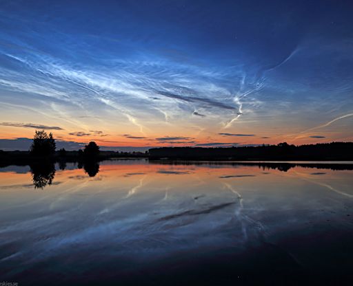
Noctilucent clouds (NCL’s) are probably the rarest clouds in our atmosphere and are certainly the HIGHEST seen over Earth.  These thin, electric blue clouds are naturally seen about 30-50 miles above the Earth in polar regions during their summer seasons.  (In comparison, the tops of extremely strong thunderstorms only reach 12-13 miles high.)  They are believed to be formed as moisture condenses around “meteor dust.”  Few people have ever seen them.  The pictures below are from www.spaceweather.com  This one was taken by P.M. Heden of Sweden.  heaven_strip

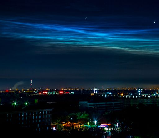
We also have man-made varieties of NCLs.  This picture was taken yesterday at Cape Canaveral about an hour and a half after AsiaSat 8 telecommunications satellite was launched by a SpaceX Falcon 9 rocket.  The photographer was Mike Bartils.            nlcs_strip

Spaceweather.com  has a library of photos of NCLs if you’d like to see more.

Add a few more clouds, but will they make rain?

Tuesday afternoon

A pocket of upper air moisture has been bringing us a thin layer of clouds, but the lower levels remain dry, so no rain is expected.  As mentioned yesterday, the appearance of 20%,30% or 40% chances for rain/t-storms in EVERY forecast period for the next 4-5 days is a good marker of uncertainty in weather forecasts.  While there is a varying chance for rain in every 12-hour period for at least the next 96 hours, I feel it’ll only happen in one or two of those periods.  Some examples:  tonight, too dry; tomorrow, marginal moisture, but upper air confluence says “no”; tomorrow night, decent chance, but it appears the rain/storm system will stay over the western third of KY, etc, etc.

I’ve never liked the “could happen” forecast although I must admit I used if often enough. Nevertheless, I much prefer the “will happen” over “could”.  However, in the summer my preference is an easy way to drive one crazy, what with all the little nuances than occur daily with thunderstorm systems.  That said, I’ll take my saw with me as I go out on the limb.  My two choices – Thursday daytime (possibly beginning early in the morning) and again Friday daytime.  Not good news for the PGA, but at least Saturday and Sunday look to be dry (from this far away).

Still quiet

Monday afternoon

Weather patterns remain weak and quiet – typical of late summer.  Models are trying to bring in several attempts for rain later this week, but, as often happens this time of year, most of them probably won’t pan out.  Looks dry through Wednesday, but there appears to be a minimal chance for rain both tomorrow night and again Wednesday night.  Best prospect  at this time looks like Thursday for some showers/thunderstorms.  But, Thursday is a long way away in a weak flow pattern, so anything could happen.  Meanwhile, hot days (near 90) and mild nights (mid 60’s) and very dry.